Property Record
1601 Nw 119Th St, Miami, FL 33167
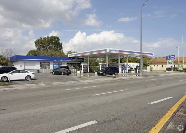


This Property Is For Sale
NEARBY LISTINGS FOR SALE OR LEASE
Property Detail
1601 Nw 119Th St
Miami-Miami Beach-Kendall, FL
Sunkist Grove
06-2126-016-7260
SUNKIST GROVE PB 8-49 LOTS 21 TO 24 INC LESS S15FT FOR R/W BLK 40 LOT SIZE IRREGULAR OR 12875-1365 0486 4
Servicestation
Miami/Dade
X
Florida
12086C0138L
21-24
2024
0.53 AC
2025
Miami Gardens/Opa Locka
000410
South Florida
5,045 SF
DEMOGRAPHICS near 1601 Nw 119Th St
1 Mile
3 Mile
5 Mile
2024 Total Population
19,388
157,530
469,285
2029 Population
18,652
152,512
457,989
Pop Growth 2024-2029
(3.80%)
(3.19%)
(2.41%)
Average Age
40
40
40
2024 Total Households
5,741
49,622
155,136
HH Growth 2024-2029
(4.13%)
(3.59%)
(2.68%)
Median Household Inc
$52,951
$44,283
$44,750
Avg Household Size
3.20
3.00
2.90
2024 Avg HH Vehicles
2.00
2.00
2.00
Median Home Value
$259,339
$298,602
$318,262
Median Year Built
1956
1958
1963
Nearby Places
Map Layers
Map Styles
 Street
 Aerial
- Restaurants
- Banks
- Shops
- Fitness
- Groceries
PUBLIC TRANSPORTATION
COMMUTER RAIL
Opa-Locka (Tri-County Commuter - South Florida Regional Transportation Authority (Tri-Rail))
DRIVE
WALK
Distance
Opa-Locka (Tri-County Commuter - South Florida Regional Transportation Authority (Tri-Rail))
7 min
3.0 mi
Northside (Metrorail Green Line - Miami-Dade Transit (Metrorail/Metromover))
DRIVE
WALK
Distance
Northside (Metrorail Green Line - Miami-Dade Transit (Metrorail/Metromover))
9 min
4.2 mi
AIRPORT
Miami International
DRIVE
WALK
Distance
Miami International
27 min
12.3 mi
Fort Lauderdale/Hollywood International
DRIVE
WALK
Distance
Fort Lauderdale/Hollywood International
25 min
16.4 mi
Freight Ports
Port of Miami
DRIVE
WALK
Distance
Port of Miami
18 min
10.6 mi
Nearby Properties
Address
Land Use
TOTAL SIZE
Lot Size
Zoning
Address
Land Use
TOTAL SIZE
Lot Size
Zoning
510,395 SF
28.32 AC
6500
Address
Land Use
TOTAL SIZE
Lot Size
Zoning
970,804 SF
46.92 AC
7100
Address
Land Use
TOTAL SIZE
Lot Size
Zoning
968,497 SF
58.61 AC
7100
Address
Land Use
TOTAL SIZE
Lot Size
Zoning
803,285 SF
63.32 AC
7100
Address
Land Use
TOTAL SIZE
Lot Size
Zoning
798,937 SF
15.25 AC
7100
Address
Land Use
TOTAL SIZE
Lot Size
Zoning
603,504 SF
27.15 AC
7100
Address
Land Use
TOTAL SIZE
Lot Size
Zoning
656,930 SF
37.70 AC
8200
Address
Land Use
TOTAL SIZE
Lot Size
Zoning
270,687 SF
7.06 AC
4100
Address
Land Use
TOTAL SIZE
Lot Size
Zoning
207,475 SF
51.47 AC
7100
Address
Land Use
TOTAL SIZE
Lot Size
Zoning
73,727 SF
232.58 AC
8054
Address
Land Use
TOTAL SIZE
Lot Size
Zoning
680,945 SF
35.56 AC
6400
Address
Land Use
TOTAL SIZE
Lot Size
Zoning
11,333 SF
7.11 AC
9000
Address
Land Use
TOTAL SIZE
Lot Size
Zoning
366,063 SF
57.35 AC
7100
Address
Land Use
TOTAL SIZE
Lot Size
Zoning
293,276 SF
39.44 AC
8200
Address
Land Use
TOTAL SIZE
Lot Size
Zoning
254,859 SF
14.59 AC
7400
Address
Land Use
TOTAL SIZE
Lot Size
Zoning
204,447 SF
12.29 AC
0100
Address
Land Use
TOTAL SIZE
Lot Size
Zoning
900 SF
80 AC
8900
Address
Land Use
TOTAL SIZE
Lot Size
Zoning
244,374 SF
20.29 AC
7052
Address
Land Use
TOTAL SIZE
Lot Size
Zoning
343,553 SF
12.08 AC
7100
Address
Land Use
TOTAL SIZE
Lot Size
Zoning
504,970 SF
29.65 AC
5000
Address
Land Use
TOTAL SIZE
Lot Size
Zoning
15,040 SF
119.27 AC
8000
Address
Land Use
TOTAL SIZE
Lot Size
Zoning
116,472 SF
88.88 AC
9400
Address
Land Use
TOTAL SIZE
Lot Size
Zoning
213,337 SF
16.54 AC
0400
Address
Land Use
TOTAL SIZE
Lot Size
Zoning
233,988 SF
11.25 AC
7100
Address
Land Use
TOTAL SIZE
Lot Size
Zoning
161,909 SF
5.01 AC
6061
Address
Land Use
TOTAL SIZE
Lot Size
Zoning
239,410 SF
10.14 AC
7100
Address
Land Use
TOTAL SIZE
Lot Size
Zoning
107,203 SF
11.85 AC
6062
Address
Land Use
TOTAL SIZE
Lot Size
Zoning
140,261 SF
17.18 AC
0100
Address
Land Use
TOTAL SIZE
Lot Size
Zoning
118,245 SF
2.49 AC
6174
Address
Land Use
TOTAL SIZE
Lot Size
Zoning
281,581 SF
11.02 AC
5000
The World's #1 Commercial Real Estate Marketplace
Connect with us
© 2025 CoStar Group
The information above has been obtained from sources believed reliable. While we do not doubt its accuracy we have not verified it and make no guarantee, warranty or representation about it. It is your responsibility to independently confirm its accuracy and completeness. Any projections, opinions, assumptions, or estimates used are for example only and do not represent the current or future performance of the property. The value of this transaction to you depends on tax and other factors which should be evaluated by your tax, financial, and legal advisors. You and your advisors should conduct a careful, independent investigation of the property to determine to your satisfaction the suitability of the property for your needs.