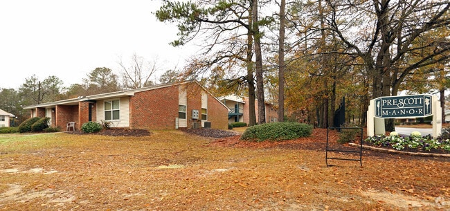
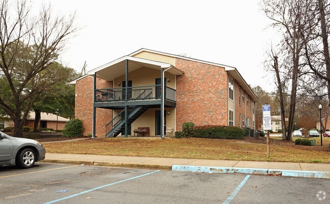
Property Record
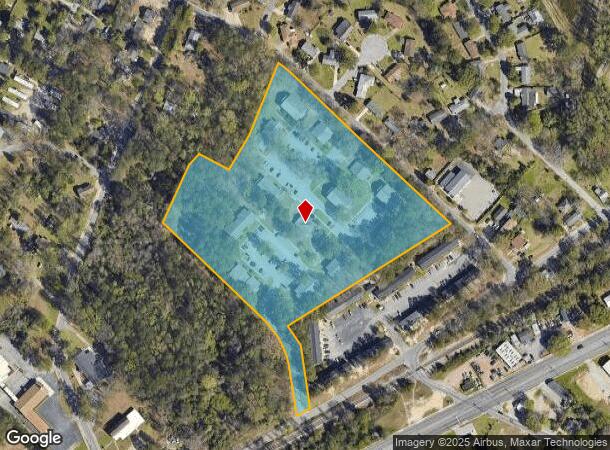
1601 Prescott Rd, Columbia, SC 29203
NEARBY LISTINGS FOR SALE OR LEASE
-
-
View all Columbia listings for sale on LoopNet.com
Property Detail
1601 Prescott Rd
11709-04-01
PRESCOTT MANOR APTS. #PR #OM 0237-05-02
Apartment
Richland
X
South Carolina
45079C0242L
10.15 AC
2025
North College Place
2024
Columbia
000100
Columbia, SC
82,232 SF
DEMOGRAPHICS near 1601 Prescott Rd
1 Mile
3 Mile
5 Mile
2024 Total Population
7,622
53,333
150,705
2029 Population
7,830
54,490
153,309
Pop Growth 2024-2029
+ 2.73%
+ 2.17%
+ 1.73%
Average Age
40
40
37
2024 Total Households
3,271
22,822
62,459
HH Growth 2024-2029
+ 2.78%
+ 2.27%
+ 1.82%
Median Household Inc
$29,880
$38,435
$44,495
Avg Household Size
2.20
2.20
2.10
2024 Avg HH Vehicles
1.00
1.00
2.00
Median Home Value
$95,431
$152,985
$193,863
Median Year Built
1966
1964
1969
Nearby Places
Map Layers
Map Styles
 Street
 Aerial
- Restaurants
- Banks
- Shops
- Fitness
- Groceries
PUBLIC TRANSPORTATION
COMMUTER RAIL
Columbia Amtrak Station (Silver Star - Amtrak)
DRIVE
WALK
Distance
Columbia Amtrak Station (Silver Star - Amtrak)
12 min
6.0 mi
AIRPORT
Columbia Metro
DRIVE
WALK
Distance
Columbia Metro
30 min
15.4 mi
Freight Ports
North Charleston Terminal
DRIVE
WALK
Distance
North Charleston Terminal
130 min
111.7 mi
Nearby Properties
Address
Land Use
TOTAL SIZE
Lot Size
Zoning
Address
Land Use
TOTAL SIZE
Lot Size
Zoning
501,365 SF
13.28 AC
O-I
Address
Land Use
TOTAL SIZE
Lot Size
Zoning
20,434 SF
17.20 AC
C-1
Address
Land Use
TOTAL SIZE
Lot Size
Zoning
100 SF
156.42 AC
RSF-2
Address
Land Use
TOTAL SIZE
Lot Size
Zoning
172,390 SF
19.87 AC
GC
Address
Land Use
TOTAL SIZE
Lot Size
Zoning
313,244 SF
12.75 AC
RM-HD
Address
Land Use
TOTAL SIZE
Lot Size
Zoning
100 SF
15.68 AC
RG-2
Address
Land Use
TOTAL SIZE
Lot Size
Zoning
200,609 SF
17.97 AC
GC
Address
Land Use
TOTAL SIZE
Lot Size
Zoning
183,237 SF
13.65 AC
GC
Address
Land Use
TOTAL SIZE
Lot Size
Zoning
2,456 SF
5 AC
C-1
Address
Land Use
TOTAL SIZE
Lot Size
Zoning
96,189 SF
2.22 AC
C-1
Address
Land Use
TOTAL SIZE
Lot Size
Zoning
23,379 SF
3.76 AC
M-1
Address
Land Use
TOTAL SIZE
Lot Size
Zoning
115,734 SF
0.98 AC
C-1
Address
Land Use
TOTAL SIZE
Lot Size
Zoning
55.91 AC
M-1
Address
Land Use
TOTAL SIZE
Lot Size
Zoning
277,459 SF
9.74 AC
C-1
Address
Land Use
TOTAL SIZE
Lot Size
Zoning
65,058 SF
3.54 AC
C-1
Address
Land Use
TOTAL SIZE
Lot Size
Zoning
34,393 SF
2.96 AC
M-1
Address
Land Use
TOTAL SIZE
Lot Size
Zoning
67,200 SF
1.72 AC
C-1
Address
Land Use
TOTAL SIZE
Lot Size
Zoning
51,353 SF
7.01 AC
GC
Address
Land Use
TOTAL SIZE
Lot Size
Zoning
90,430 SF
0.42 AC
C-1
Address
Land Use
TOTAL SIZE
Lot Size
Zoning
132,097 SF
10.63 AC
GC
Address
Land Use
TOTAL SIZE
Lot Size
Zoning
1,199.74 AC
OI
Address
Land Use
TOTAL SIZE
Lot Size
Zoning
124,272 SF
7.06 AC
RM-HD
Address
Land Use
TOTAL SIZE
Lot Size
Zoning
100 SF
44.73 AC
C-1
Address
Land Use
TOTAL SIZE
Lot Size
Zoning
63,842 SF
3.52 AC
C-3
Address
Land Use
TOTAL SIZE
Lot Size
Zoning
4,986 SF
5.74 AC
PUD-C
Address
Land Use
TOTAL SIZE
Lot Size
Zoning
138,738 SF
2.85 AC
O-I
Address
Land Use
TOTAL SIZE
Lot Size
Zoning
103,405 SF
0.38 AC
C-3
Address
Land Use
TOTAL SIZE
Lot Size
Zoning
82,692 SF
5.87 AC
C-3
Address
Land Use
TOTAL SIZE
Lot Size
Zoning
134,400 SF
5.85 AC
RG-2
Address
Land Use
TOTAL SIZE
Lot Size
Zoning
100 SF
4.44 AC
C-3
The World's #1 Commercial Real Estate Marketplace
Connect with us
© 2026 CoStar Group
The information above has been obtained from sources believed reliable. While we do not doubt its accuracy we have not verified it and make no guarantee, warranty or representation about it. It is your responsibility to independently confirm its accuracy and completeness. Any projections, opinions, assumptions, or estimates used are for example only and do not represent the current or future performance of the property. The value of this transaction to you depends on tax and other factors which should be evaluated by your tax, financial, and legal advisors. You and your advisors should conduct a careful, independent investigation of the property to determine to your satisfaction the suitability of the property for your needs.