Property Record
1601 S St Augustine Rd, Dallas, TX 75217
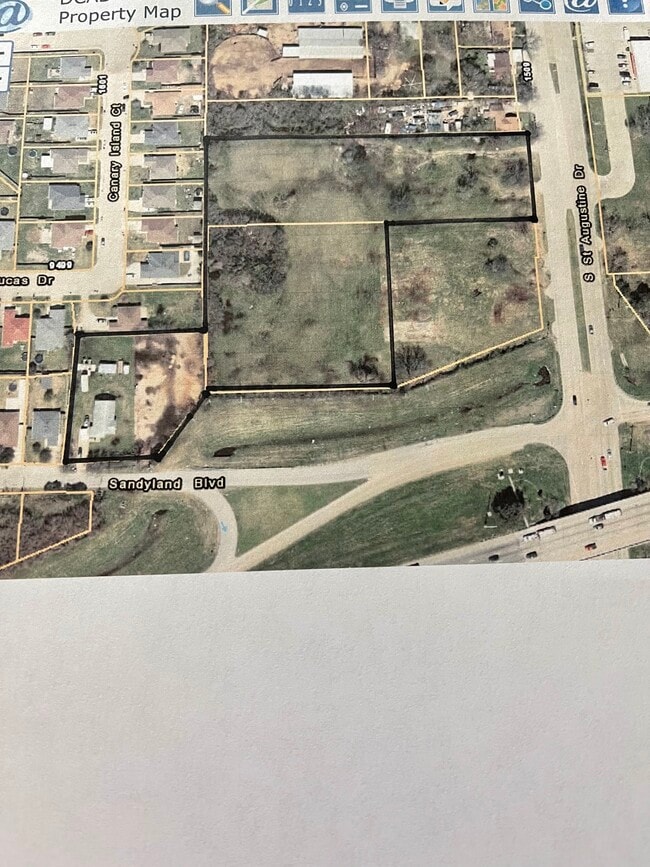
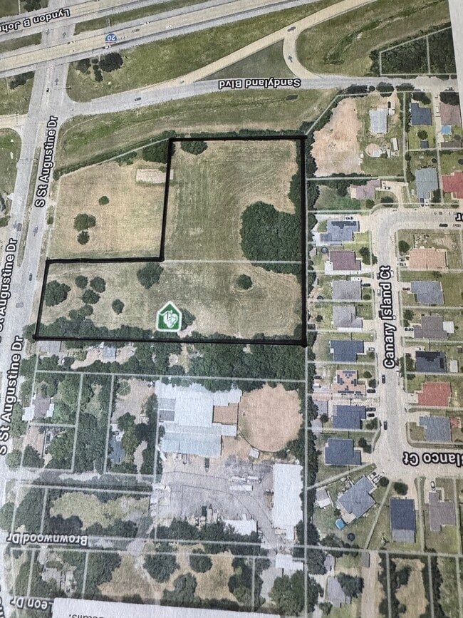
This Property Is For Sale
Property Detail
1601 S St Augustine Rd
Dallas-Fort Worth-Arlington, TX
BLK 8497 TR 14 ACS 2.0821 VOL2004210/10847 DD10252004 CO-DC 8497 000 01400 3DA8497 000
00000813550000000
DALLAS
Commercialacreage
Texas
Z294
14
B and X Area of moderate flood hazard, usually the area between the limits of the 100-year and 500-year floods.
2.08 AC
2024
Southeast Dallas
2025
Dallas/Ft Worth
009202
NEARBY LISTINGS FOR SALE OR LEASE
DEMOGRAPHICS near 1601 S St Augustine Rd
1 mile
3 mile
5 mile
2025 Total Population
6,028
45,857
164,531
2030 Population
6,228
47,271
169,113
Pop Growth 2025-2030
+ 3.32%
+ 3.08%
+ 2.78%
Average Age
33
34
34
2025 Total Households
1,593
11,894
45,581
HH Growth 2025-2030
+ 3.45%
+ 3.30%
+ 2.86%
Median Household Inc
$67,228
$58,407
$58,766
Avg Household Size
3.70
3.60
3.50
2025 Avg HH Vehicles
2.00
2.00
2.00
Median Home Value
$233,450
$200,765
$201,281
Median Year Built
1986
1974
1976
Nearby Places
Map Layers
Map Styles
 Street
 Aerial
Layers
 Traffic
 Biking
Places
Listings with unknown addresses are not visible on the map
- Restaurants
- Banks
- Shops
- Fitness
- Groceries
PUBLIC TRANSPORTATION
AIRPORT
Dallas Love Field
Drive
Walk
Distance
Dallas Love Field
28 min
17.7 mi
Dallas-Fort Worth International
Drive
Walk
Distance
Dallas-Fort Worth International
44 min
33.6 mi
Freight Ports
Port of Shreveport
Drive
Walk
Distance
Port of Shreveport
200 min
187.1 mi
Nearby Properties
Address
Land Use
TOTAL SIZE
Lot Size
Zoning
Address
Land Use
TOTAL SIZE
Lot Size
Zoning
800,737 SF
45.33 AC
Z123
Address
Land Use
TOTAL SIZE
Lot Size
Zoning
257,745 SF
31.54 AC
Z298
Address
Land Use
TOTAL SIZE
Lot Size
Zoning
218,804 SF
13.79 AC
Z164
Address
Land Use
TOTAL SIZE
Lot Size
Zoning
141,566 SF
23 AC
Z298
Address
Land Use
TOTAL SIZE
Lot Size
Zoning
342,132 SF
18.04 AC
Z163
Address
Land Use
TOTAL SIZE
Lot Size
Zoning
234,459 SF
9.71 AC
Z138
Address
Land Use
TOTAL SIZE
Lot Size
Zoning
123,499 SF
8.32 AC
Z239
Address
Land Use
TOTAL SIZE
Lot Size
Zoning
667,344 SF
22.98 AC
Z115
Address
Land Use
TOTAL SIZE
Lot Size
Zoning
118,237 SF
5.56 AC
Z183
Address
Land Use
TOTAL SIZE
Lot Size
Zoning
177,277 SF
11.57 AC
Z123
Address
Land Use
TOTAL SIZE
Lot Size
Zoning
143,713 SF
9.29 AC
Z59
Address
Land Use
TOTAL SIZE
Lot Size
Zoning
160,000 SF
9.60 AC
Z250
Address
Land Use
TOTAL SIZE
Lot Size
Zoning
203 SF
23.94 AC
MFA
Address
Land Use
TOTAL SIZE
Lot Size
Zoning
96,196 SF
8 AC
Z06
Address
Land Use
TOTAL SIZE
Lot Size
Zoning
81,210 SF
12.91 AC
Z298
Address
Land Use
TOTAL SIZE
Lot Size
Zoning
106,380 SF
15.82 AC
Z139
Address
Land Use
TOTAL SIZE
Lot Size
Zoning
150,207 SF
9 AC
Z236
Address
Land Use
TOTAL SIZE
Lot Size
Zoning
191 SF
23.10 AC
Z05
Address
Land Use
TOTAL SIZE
Lot Size
Zoning
130,501 SF
10.37 AC
Z236
Address
Land Use
TOTAL SIZE
Lot Size
Zoning
131,821 SF
8.96 AC
Address
Land Use
TOTAL SIZE
Lot Size
Zoning
92,256 SF
9.93 AC
Z298
Address
Land Use
TOTAL SIZE
Lot Size
Zoning
42,112 SF
0.03 AC
Z06
Address
Land Use
TOTAL SIZE
Lot Size
Zoning
61,685 SF
6.94 AC
Z298
Address
Land Use
TOTAL SIZE
Lot Size
Zoning
40,396 SF
9.45 AC
Z298
Address
Land Use
TOTAL SIZE
Lot Size
Zoning
265,068 SF
18.17 AC
Z163
Address
Land Use
TOTAL SIZE
Lot Size
Zoning
115,492 SF
14.16 AC
Z298
Address
Land Use
TOTAL SIZE
Lot Size
Zoning
20,820 SF
7.50 AC
Z239
Address
Land Use
TOTAL SIZE
Lot Size
Zoning
73,250 SF
5.94 AC
Z139
Address
Land Use
TOTAL SIZE
Lot Size
Zoning
86,644 SF
12.94 AC
Z297
Address
Land Use
TOTAL SIZE
Lot Size
Zoning
61,704 SF
12.35 AC
Z294
The World's #1 Commercial Real Estate Marketplace
Connect with us
© 2026 CoStar Group
The information above has been obtained from sources believed reliable. While we do not doubt its accuracy we have not verified it and make no guarantee, warranty or representation about it. It is your responsibility to independently confirm its accuracy and completeness. Any projections, opinions, assumptions, or estimates used are for example only and do not represent the current or future performance of the property. The value of this transaction to you depends on tax and other factors which should be evaluated by your tax, financial, and legal advisors. You and your advisors should conduct a careful, independent investigation of the property to determine to your satisfaction the suitability of the property for your needs.