Property Record
1601 W Mckinley Ave, Fresno, CA 93728
NEARBY LISTINGS FOR SALE OR LEASE
Property Detail
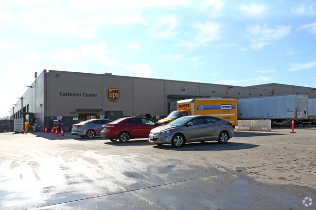
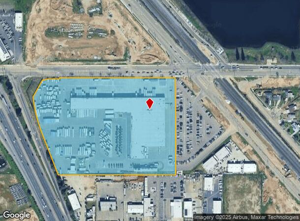
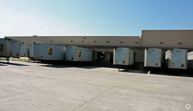
1601 W Mckinley Ave
449-020-48S
12.84 AC SUR RT IN LOTS 94 & 96 ROEDINGS VILLA COL
Truckterminal
Fresno
X
California
06019C1565H
12.84 AC
2025
Northwest Fresno
2025
Fresno
002000
Fresno, CA
108,764 SF
DEMOGRAPHICS near 1601 W Mckinley Ave
1 Mile
3 Mile
5 Mile
2024 Total Population
17,258
132,819
324,945
2029 Population
17,592
135,181
331,242
Pop Growth 2024-2029
+ 1.94%
+ 1.78%
+ 1.94%
Average Age
35
35
35
2024 Total Households
5,589
42,981
104,370
HH Growth 2024-2029
+ 1.91%
+ 1.77%
+ 1.95%
Median Household Inc
$42,293
$47,773
$51,576
Avg Household Size
3.00
2.90
3.00
2024 Avg HH Vehicles
2.00
2.00
2.00
Median Home Value
$211,424
$253,704
$274,303
Median Year Built
1960
1964
1969
Nearby Places
Map Layers
Map Styles
 Street
 Aerial
- Restaurants
- Banks
- Shops
- Fitness
- Groceries
PUBLIC TRANSPORTATION
COMMUTER RAIL
Fresno (San Joaquins - Amtrak)
DRIVE
WALK
Distance
Fresno (San Joaquins - Amtrak)
8 min
3.9 mi
AIRPORT
Fresno Yosemite International
DRIVE
WALK
Distance
Fresno Yosemite International
13 min
6.8 mi
Freight Ports
Port of Stockton
DRIVE
WALK
Distance
Port of Stockton
147 min
124.3 mi
Nearby Properties
Address
Land Use
TOTAL SIZE
Lot Size
Zoning
Address
Land Use
TOTAL SIZE
Lot Size
Zoning
0.01 AC
P
Address
Land Use
TOTAL SIZE
Lot Size
Zoning
534,993 SF
5.23 AC
CP
Address
Land Use
TOTAL SIZE
Lot Size
Zoning
184,130 SF
1.87 AC
PI
Address
Land Use
TOTAL SIZE
Lot Size
Zoning
234,370 SF
23 AC
SPLIT
Address
Land Use
TOTAL SIZE
Lot Size
Zoning
471,760 SF
1.98 AC
CP
Address
Land Use
TOTAL SIZE
Lot Size
Zoning
232,183 SF
18.32 AC
R2A
Address
Land Use
TOTAL SIZE
Lot Size
Zoning
79,518 SF
2.03 AC
R4
Address
Land Use
TOTAL SIZE
Lot Size
Zoning
480,570 SF
2.98 AC
P
Address
Land Use
TOTAL SIZE
Lot Size
Zoning
110,456 SF
6.56 AC
RMX
Address
Land Use
TOTAL SIZE
Lot Size
Zoning
96,012 SF
1.33 AC
C4
Address
Land Use
TOTAL SIZE
Lot Size
Zoning
669,447 SF
0.01 AC
C3
Address
Land Use
TOTAL SIZE
Lot Size
Zoning
96,012 SF
0.60 AC
C4
Address
Land Use
TOTAL SIZE
Lot Size
Zoning
203,687 SF
10.63 AC
R3
Address
Land Use
TOTAL SIZE
Lot Size
Zoning
121,250 SF
9.51 AC
R3
Address
Land Use
TOTAL SIZE
Lot Size
Zoning
159,822 SF
9.67 AC
R2
Address
Land Use
TOTAL SIZE
Lot Size
Zoning
110,341 SF
5.45 AC
R3
Address
Land Use
TOTAL SIZE
Lot Size
Zoning
191,136 SF
12.12 AC
R2
Address
Land Use
TOTAL SIZE
Lot Size
Zoning
92,096 SF
0.01 AC
C3
Address
Land Use
TOTAL SIZE
Lot Size
Zoning
91,517 SF
1.80 AC
SPLIT
Address
Land Use
TOTAL SIZE
Lot Size
Zoning
145,783 SF
9.22 AC
R2
Address
Land Use
TOTAL SIZE
Lot Size
Zoning
108,017 SF
2.91 AC
CM
Address
Land Use
TOTAL SIZE
Lot Size
Zoning
372,640 SF
4.35 AC
CP
Address
Land Use
TOTAL SIZE
Lot Size
Zoning
71,384 SF
6.34 AC
IL
Address
Land Use
TOTAL SIZE
Lot Size
Zoning
83,622 SF
3.98 AC
M1
Address
Land Use
TOTAL SIZE
Lot Size
Zoning
106,740 SF
63.59 AC
AE20
Address
Land Use
TOTAL SIZE
Lot Size
Zoning
68,222 SF
2.73 AC
R3
Address
Land Use
TOTAL SIZE
Lot Size
Zoning
24,241 SF
7.73 AC
R3
Address
Land Use
TOTAL SIZE
Lot Size
Zoning
32,156 SF
2.60 AC
C6
Address
Land Use
TOTAL SIZE
Lot Size
Zoning
130,053 SF
0.69 AC
C4
The World's #1 Commercial Real Estate Marketplace
Connect with us
© 2026 CoStar Group
The information above has been obtained from sources believed reliable. While we do not doubt its accuracy we have not verified it and make no guarantee, warranty or representation about it. It is your responsibility to independently confirm its accuracy and completeness. Any projections, opinions, assumptions, or estimates used are for example only and do not represent the current or future performance of the property. The value of this transaction to you depends on tax and other factors which should be evaluated by your tax, financial, and legal advisors. You and your advisors should conduct a careful, independent investigation of the property to determine to your satisfaction the suitability of the property for your needs.