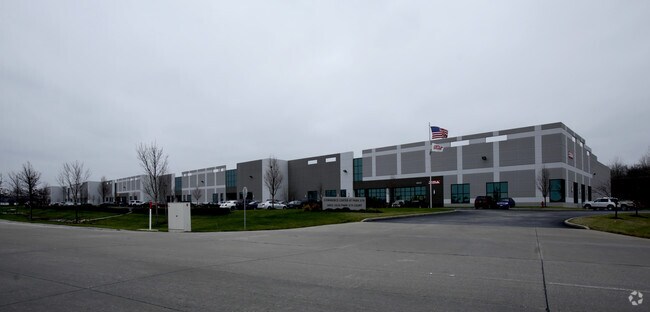
Property Record
1602 Park 370 Ct, Hazelwood, MO 63042

Current Lease Availabilities
NEARBY LISTINGS FOR SALE OR LEASE
Property Detail
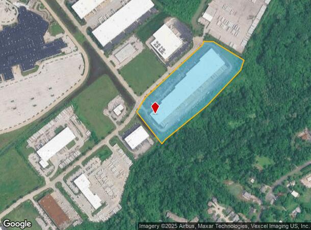
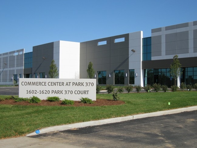
1602 Park 370 Ct
St. Louis, MO-IL
Park 370 Plat Two Lots 10 & 11 & Park
08M-12-0135
PARK 370 PLAT TWO LOTS 10 & 11 & PARK 370 PLAT THREE LOT 12 RESUB LOT A
Warehouse
St. Louis
A
Missouri
29183C0295G
a,12
2024
16.42 AC
2025
North County
211401
St. Louis
216,000 SF
DEMOGRAPHICS near 1602 Park 370 Ct
1 Mile
3 Mile
5 Mile
2024 Total Population
4,358
27,770
120,235
2029 Population
4,287
27,210
119,150
Pop Growth 2024-2029
(1.63%)
(2.02%)
(0.90%)
Average Age
38
40
40
2024 Total Households
2,030
11,861
49,845
HH Growth 2024-2029
(1.58%)
(2.09%)
(0.92%)
Median Household Inc
$51,077
$60,894
$58,480
Avg Household Size
2.10
2.30
2.30
2024 Avg HH Vehicles
2.00
2.00
2.00
Median Home Value
$145,200
$163,417
$155,226
Median Year Built
1969
1969
1964
Nearby Places
Map Layers
Map Styles
 Street
 Aerial
- Restaurants
- Banks
- Shops
- Fitness
- Groceries
PUBLIC TRANSPORTATION
AIRPORT
St Louis Lambert International
DRIVE
WALK
Distance
St Louis Lambert International
13 min
6.8 mi
Freight Ports
Port Milwaukee
DRIVE
WALK
Distance
Port Milwaukee
433 min
379.9 mi
Nearby Properties
Address
Land Use
TOTAL SIZE
Lot Size
Zoning
Address
Land Use
TOTAL SIZE
Lot Size
Zoning
1,817,830 SF
75.99 AC
M1
Address
Land Use
TOTAL SIZE
Lot Size
Zoning
449,698 SF
47.19 AC
R3
Address
Land Use
TOTAL SIZE
Lot Size
Zoning
4,416 SF
54.81 AC
80B
Address
Land Use
TOTAL SIZE
Lot Size
Zoning
833,525 SF
25.53 AC
R1
Address
Land Use
TOTAL SIZE
Lot Size
Zoning
893,188 SF
71.88 AC
G
Address
Land Use
TOTAL SIZE
Lot Size
Zoning
528,000 SF
21.10 AC
80I
Address
Land Use
TOTAL SIZE
Lot Size
Zoning
542,500 SF
39.91 AC
FPNU
Address
Land Use
TOTAL SIZE
Lot Size
Zoning
662,199 SF
26.58 AC
10M-1
Address
Land Use
TOTAL SIZE
Lot Size
Zoning
448,590 SF
24.75 AC
M3
Address
Land Use
TOTAL SIZE
Lot Size
Zoning
491,800 SF
18.69 AC
80AG
Address
Land Use
TOTAL SIZE
Lot Size
Zoning
67,891 SF
4 AC
R3
Address
Land Use
TOTAL SIZE
Lot Size
Zoning
406,000 SF
18.82 AC
80CA
Address
Land Use
TOTAL SIZE
Lot Size
Zoning
317,145 SF
21.71 AC
10M-1
Address
Land Use
TOTAL SIZE
Lot Size
Zoning
403,200 SF
21.99 AC
10M-1
Address
Land Use
TOTAL SIZE
Lot Size
Zoning
445,715 SF
28.16 AC
80I
Address
Land Use
TOTAL SIZE
Lot Size
Zoning
343,900 SF
19.62 AC
80AG
Address
Land Use
TOTAL SIZE
Lot Size
Zoning
119,925 SF
72.26 AC
10M-1
Address
Land Use
TOTAL SIZE
Lot Size
Zoning
335,294 SF
33.83 AC
24MFD
Address
Land Use
TOTAL SIZE
Lot Size
Zoning
6.88 AC
H
Address
Land Use
TOTAL SIZE
Lot Size
Zoning
293,622 SF
28.06 AC
H
Address
Land Use
TOTAL SIZE
Lot Size
Zoning
161,536 SF
7.91 AC
R5
Address
Land Use
TOTAL SIZE
Lot Size
Zoning
269,258 SF
89.80 AC
80F
Address
Land Use
TOTAL SIZE
Lot Size
Zoning
534,068 SF
39.76 AC
M1
Address
Land Use
TOTAL SIZE
Lot Size
Zoning
135,721 SF
5.40 AC
80F
Address
Land Use
TOTAL SIZE
Lot Size
Zoning
278,550 SF
18 AC
10M-1
Address
Land Use
TOTAL SIZE
Lot Size
Zoning
86,082 SF
10 AC
R3
Address
Land Use
TOTAL SIZE
Lot Size
Zoning
387,158 SF
34.19 AC
R6
Address
Land Use
TOTAL SIZE
Lot Size
Zoning
780,115 SF
17.91 AC
PD
Address
Land Use
TOTAL SIZE
Lot Size
Zoning
259,988 SF
16.64 AC
M3
The World's #1 Commercial Real Estate Marketplace
Connect with us
© 2026 CoStar Group
The information above has been obtained from sources believed reliable. While we do not doubt its accuracy we have not verified it and make no guarantee, warranty or representation about it. It is your responsibility to independently confirm its accuracy and completeness. Any projections, opinions, assumptions, or estimates used are for example only and do not represent the current or future performance of the property. The value of this transaction to you depends on tax and other factors which should be evaluated by your tax, financial, and legal advisors. You and your advisors should conduct a careful, independent investigation of the property to determine to your satisfaction the suitability of the property for your needs.