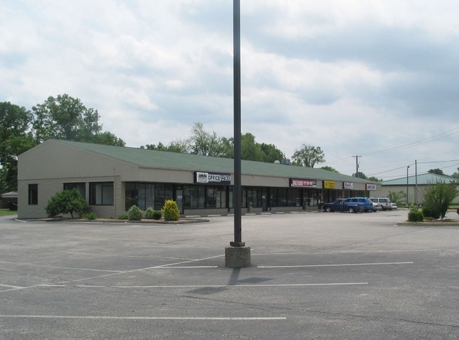
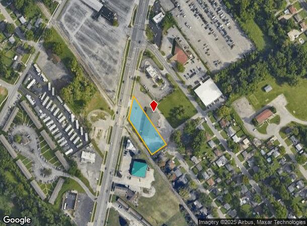
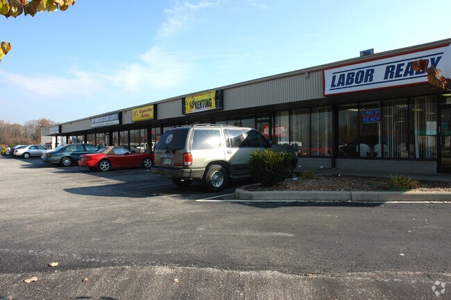
Property Record
1602 E 10Th St, Jeffersonville, IN 47130
NEARBY LISTINGS FOR SALE OR LEASE
Property Detail
1602 E 10Th St
10-19-01-000-526.000-010
GT 10 -1.377 AC
Stripcommercialcenter
Clark
X
Indiana
18019C0286E
1.38 AC
2024
South Clark County
2024
Louisville
050303
Louisville-Jefferson County, KY-IN
11,617 SF
DEMOGRAPHICS near 1602 E 10Th St
1 Mile
3 Mile
5 Mile
2024 Total Population
10,951
64,857
191,910
2029 Population
11,644
68,256
196,835
Pop Growth 2024-2029
+ 6.33%
+ 5.24%
+ 2.57%
Average Age
40
40
41
2024 Total Households
4,760
29,150
87,798
HH Growth 2024-2029
+ 6.34%
+ 5.14%
+ 2.44%
Median Household Inc
$43,835
$53,557
$51,953
Avg Household Size
2.20
2.10
2.10
2024 Avg HH Vehicles
2.00
2.00
1.00
Median Home Value
$126,846
$167,417
$203,059
Median Year Built
1964
1971
1961
Nearby Places
Map Layers
Map Styles
 Street
 Aerial
- Restaurants
- Banks
- Shops
- Fitness
- Groceries
PUBLIC TRANSPORTATION
AIRPORT
Louisville Muhammad Ali International
DRIVE
WALK
Distance
Louisville Muhammad Ali International
20 min
11.3 mi
Freight Ports
Port of Toledo
DRIVE
WALK
Distance
Port of Toledo
353 min
304.9 mi
SALE & LEASE HISTORY
LISTING DATE
SALE/LEASE

Sep 25, 2016
For Lease
Apr 27, 2023
For Sale
Nearby Properties
Address
Land Use
TOTAL SIZE
Lot Size
Zoning
Address
Land Use
TOTAL SIZE
Lot Size
Zoning
4.80 AC
M3-INDUSTR
Address
Land Use
TOTAL SIZE
Lot Size
Zoning
106,330 SF
9.44 AC
M3-INDUSTR
Address
Land Use
TOTAL SIZE
Lot Size
Zoning
23.42 AC
(W
Address
Land Use
TOTAL SIZE
Lot Size
Zoning
13,240 SF
20.84 AC
Address
Land Use
TOTAL SIZE
Lot Size
Zoning
2.07 AC
Address
Land Use
TOTAL SIZE
Lot Size
Zoning
21,767 SF
1.47 AC
EZ1-ENTERP
Address
Land Use
TOTAL SIZE
Lot Size
Zoning
50,946 SF
2.66 AC
(CM)COMMER
Address
Land Use
TOTAL SIZE
Lot Size
Zoning
699,568 SF
1.96 AC
(C3)CENTRA
Address
Land Use
TOTAL SIZE
Lot Size
Zoning
6,254 SF
1.48 AC
C2-COMMERC
Address
Land Use
TOTAL SIZE
Lot Size
Zoning
400 SF
13.92 AC
R6-RESIDEN
Address
Land Use
TOTAL SIZE
Lot Size
Zoning
15.29 AC
Address
Land Use
TOTAL SIZE
Lot Size
Zoning
2.81 AC
Address
Land Use
TOTAL SIZE
Lot Size
Zoning
176,448 SF
2.45 AC
Address
Land Use
TOTAL SIZE
Lot Size
Zoning
109,470 SF
2.27 AC
Address
Land Use
TOTAL SIZE
Lot Size
Zoning
28,408 SF
1.55 AC
EZ1-ENTERP
Address
Land Use
TOTAL SIZE
Lot Size
Zoning
2.09 AC
(C3)CENTRA
Address
Land Use
TOTAL SIZE
Lot Size
Zoning
4,178 SF
10.39 AC
Address
Land Use
TOTAL SIZE
Lot Size
Zoning
Address
Land Use
TOTAL SIZE
Lot Size
Zoning
Address
Land Use
TOTAL SIZE
Lot Size
Zoning
14,720 SF
13 AC
Address
Land Use
TOTAL SIZE
Lot Size
Zoning
24,302 SF
0.27 AC
CM-COMMERC
Address
Land Use
TOTAL SIZE
Lot Size
Zoning
0.13 AC
C2-COMMERC
Address
Land Use
TOTAL SIZE
Lot Size
Zoning
120,337 SF
18.20 AC
Address
Land Use
TOTAL SIZE
Lot Size
Zoning
534,140 SF
33 AC
Address
Land Use
TOTAL SIZE
Lot Size
Zoning
16,221 SF
2.40 AC
Address
Land Use
TOTAL SIZE
Lot Size
Zoning
303,047 SF
7.21 AC
Address
Land Use
TOTAL SIZE
Lot Size
Zoning
2,208 SF
26.20 AC
Address
Land Use
TOTAL SIZE
Lot Size
Zoning
11,404 SF
19.68 AC
Address
Land Use
TOTAL SIZE
Lot Size
Zoning
2,000 SF
13.11 AC
Address
Land Use
TOTAL SIZE
Lot Size
Zoning
128,269 SF
10.18 AC
The World's #1 Commercial Real Estate Marketplace
Connect with us
© 2025 CoStar Group
The information above has been obtained from sources believed reliable. While we do not doubt its accuracy we have not verified it and make no guarantee, warranty or representation about it. It is your responsibility to independently confirm its accuracy and completeness. Any projections, opinions, assumptions, or estimates used are for example only and do not represent the current or future performance of the property. The value of this transaction to you depends on tax and other factors which should be evaluated by your tax, financial, and legal advisors. You and your advisors should conduct a careful, independent investigation of the property to determine to your satisfaction the suitability of the property for your needs.