Property Record
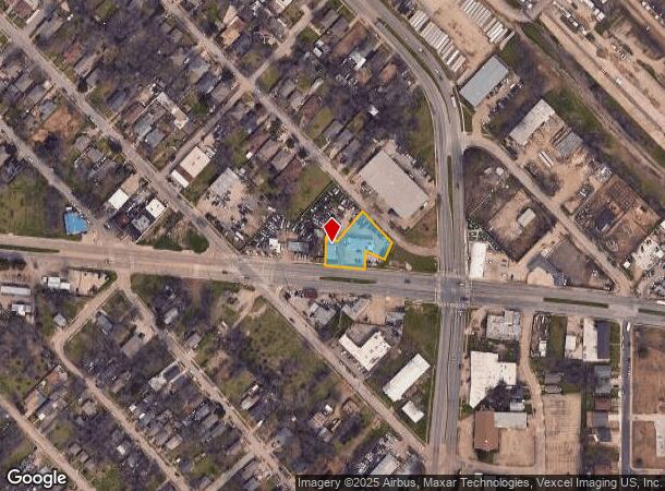
1820 S Haskell Ave, Dallas, TX 75223


NEARBY LISTINGS FOR SALE OR LEASE
Property Detail
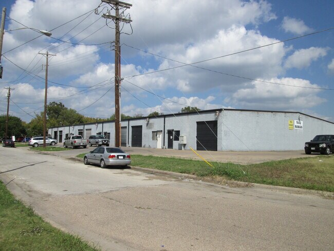
1820 S Haskell Ave
Dallas-Fort Worth-Arlington, TX
Sam E Jordans
00000154531000000
SAM E JORDANS BLK 1452 LTS 5-7 & 17-19 INT20070302350 DD08142007 CO-DC 1452 000 00500 1DA1452 000
Autorepair
Dallas
X
Texas
48113C0365K
5
2024
0.48 AC
2025
Central East Dallas
002500
Dallas/Ft Worth
4,192 SF
DEMOGRAPHICS near 1820 S Haskell Ave
1 Mile
3 Mile
5 Mile
2024 Total Population
13,699
145,026
376,996
2029 Population
13,762
146,911
379,376
Pop Growth 2024-2029
+ 0.46%
+ 1.30%
+ 0.63%
Average Age
37
36
36
2024 Total Households
4,409
66,270
172,818
HH Growth 2024-2029
+ 0.41%
+ 1.50%
+ 0.81%
Median Household Inc
$45,851
$64,929
$69,341
Avg Household Size
2.90
2.10
2.10
2024 Avg HH Vehicles
2.00
1.00
2.00
Median Home Value
$136,835
$366,756
$366,281
Median Year Built
1959
1983
1986
Nearby Places
Map Layers
Map Styles
 Street
 Aerial
- Restaurants
- Banks
- Shops
- Fitness
- Groceries
PUBLIC TRANSPORTATION
TRANSIT/SUBWAY
Fair Park (DART LIGHT RAIL - BLUE LINE - Dallas Area Rapid Transit (DART), DART LIGHT RAIL - GREEN LINE - Dallas Area Rapid Transit (DART), DART LIGHT RAIL - ORANGE LINE - Dallas Area Rapid Transit (DART), DART LIGHT RAIL - RED LINE - Dallas Area Rapid Transit (DART), Green Line - Dallas Area Rapid Transit (DART))
DRIVE
WALK
Distance
Fair Park (DART LIGHT RAIL - BLUE LINE - Dallas Area Rapid Transit (DART), DART LIGHT RAIL - GREEN LINE - Dallas Area Rapid Transit (DART), DART LIGHT RAIL - ORANGE LINE - Dallas Area Rapid Transit (DART), DART LIGHT RAIL - RED LINE - Dallas Area Rapid Transit (DART), Green Line - Dallas Area Rapid Transit (DART))
2 min
20 min
1.1 mi
COMMUTER RAIL
Victory Station (DART LIGHT RAIL - GREEN LINE - Dallas Area Rapid Transit (DART), DART LIGHT RAIL - ORANGE LINE - Dallas Area Rapid Transit (DART), TRINITY RAILWAY - Dallas Area Rapid Transit (DART))
DRIVE
WALK
Distance
Victory Station (DART LIGHT RAIL - GREEN LINE - Dallas Area Rapid Transit (DART), DART LIGHT RAIL - ORANGE LINE - Dallas Area Rapid Transit (DART), TRINITY RAILWAY - Dallas Area Rapid Transit (DART))
9 min
4.6 mi
Medical/Market Ctr Station (TRINITY RAILWAY - Dallas Area Rapid Transit (DART))
DRIVE
WALK
Distance
Medical/Market Ctr Station (TRINITY RAILWAY - Dallas Area Rapid Transit (DART))
13 min
6.5 mi
AIRPORT
Dallas Love Field
DRIVE
WALK
Distance
Dallas Love Field
17 min
7.9 mi
Dallas-Fort Worth International
DRIVE
WALK
Distance
Dallas-Fort Worth International
33 min
24.0 mi
Freight Ports
Port of Shreveport
DRIVE
WALK
Distance
Port of Shreveport
208 min
193.7 mi
SALE & LEASE HISTORY
LISTING DATE
SALE/LEASE

Sep 28, 2018
For Lease
Sep 25, 2016
For Lease
Jan 09, 2018
For Lease
Nearby Properties
Address
Land Use
TOTAL SIZE
Lot Size
Zoning
Address
Land Use
TOTAL SIZE
Lot Size
Zoning
1,676,176 SF
2.18 AC
Z239
Address
Land Use
TOTAL SIZE
Lot Size
Zoning
1,480,246 SF
1.86 AC
Z21
Address
Land Use
TOTAL SIZE
Lot Size
Zoning
1,424,070 SF
1.36 AC
Z21
Address
Land Use
TOTAL SIZE
Lot Size
Zoning
1,980,000 SF
2.57 AC
Z21
Address
Land Use
TOTAL SIZE
Lot Size
Zoning
486,300 SF
1.55 AC
Z239
Address
Land Use
TOTAL SIZE
Lot Size
Zoning
536,874 SF
1.03 AC
Z239
Address
Land Use
TOTAL SIZE
Lot Size
Zoning
2,695,010 SF
8.69 AC
Z239
Address
Land Use
TOTAL SIZE
Lot Size
Zoning
1,848,034 SF
2.29 AC
Z21
Address
Land Use
TOTAL SIZE
Lot Size
Zoning
1,003,243 SF
2.07 AC
Z21
Address
Land Use
TOTAL SIZE
Lot Size
Zoning
763,340 SF
8.31 AC
Z165
Address
Land Use
TOTAL SIZE
Lot Size
Zoning
539,723 SF
0.58 AC
Z239
Address
Land Use
TOTAL SIZE
Lot Size
Zoning
3,398,834 SF
13.45 AC
Z151
Address
Land Use
TOTAL SIZE
Lot Size
Zoning
659,884 SF
5.77 AC
Z151
Address
Land Use
TOTAL SIZE
Lot Size
Zoning
432,919 SF
0.69 AC
Z21
Address
Land Use
TOTAL SIZE
Lot Size
Zoning
454,810 SF
5.80 AC
Z239
Address
Land Use
TOTAL SIZE
Lot Size
Zoning
593,031 SF
4.66 AC
Address
Land Use
TOTAL SIZE
Lot Size
Zoning
1,142,350 SF
1.37 AC
Z21
Address
Land Use
TOTAL SIZE
Lot Size
Zoning
1,979,594 SF
1.81 AC
Z21
Address
Land Use
TOTAL SIZE
Lot Size
Zoning
799,449 SF
Z239
Address
Land Use
TOTAL SIZE
Lot Size
Zoning
1,173,721 SF
1.22 AC
Z21
Address
Land Use
TOTAL SIZE
Lot Size
Zoning
551,820 SF
5.03 AC
Z239
Address
Land Use
TOTAL SIZE
Lot Size
Zoning
1,018,066 SF
1.20 AC
Z21
Address
Land Use
TOTAL SIZE
Lot Size
Zoning
644,416 SF
1.26 AC
Z239
Address
Land Use
TOTAL SIZE
Lot Size
Zoning
741,673 SF
1.30 AC
Z21
Address
Land Use
TOTAL SIZE
Lot Size
Zoning
668,282 SF
1.94 AC
Z22
Address
Land Use
TOTAL SIZE
Lot Size
Zoning
583,186 SF
4.54 AC
Z239
Address
Land Use
TOTAL SIZE
Lot Size
Zoning
357,160 SF
0.70 AC
Z21
Address
Land Use
TOTAL SIZE
Lot Size
Zoning
661,775 SF
12.55 AC
Z151
Address
Land Use
TOTAL SIZE
Lot Size
Zoning
372,564 SF
13.34 AC
Z164
Address
Land Use
TOTAL SIZE
Lot Size
Zoning
602,021 SF
5.75 AC
Z248
The World's #1 Commercial Real Estate Marketplace
Connect with us
© 2025 CoStar Group
The information above has been obtained from sources believed reliable. While we do not doubt its accuracy we have not verified it and make no guarantee, warranty or representation about it. It is your responsibility to independently confirm its accuracy and completeness. Any projections, opinions, assumptions, or estimates used are for example only and do not represent the current or future performance of the property. The value of this transaction to you depends on tax and other factors which should be evaluated by your tax, financial, and legal advisors. You and your advisors should conduct a careful, independent investigation of the property to determine to your satisfaction the suitability of the property for your needs.