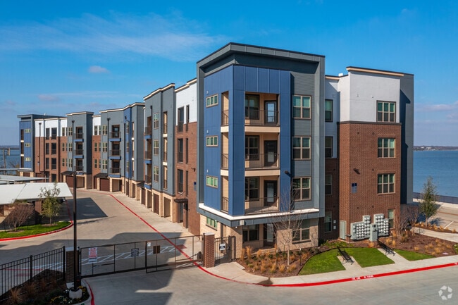
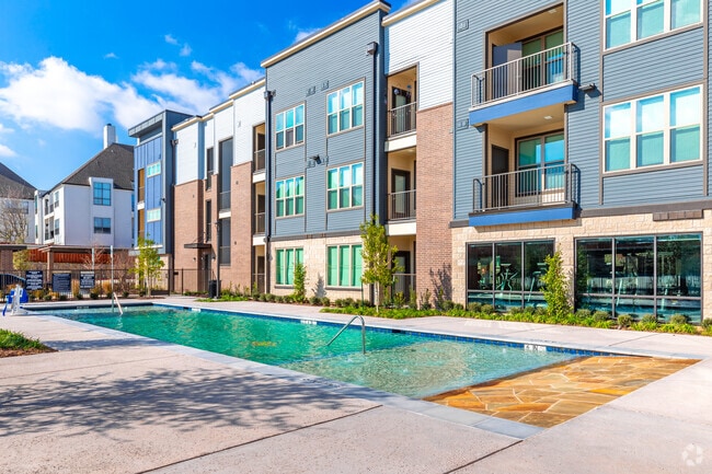
Property Record
1603 E Interstate 30, Garland, TX 75043

Save to a Folder
{{folder.Name}}
{{folder.ListingIds.length}} Properties
{{folder.ListingIds.length}} Property
Create a New Folder
Property Detail
1603 E Interstate 30
26305750010010000
LAKEVIEW POINTE BLK 1 LT 1 ACS 4.421 INT20200019093 DD07272020 CO-DC 1788000100501 2CG17880001
Apartment
DALLAS
Z239
Texas
B and X Area of moderate flood hazard, usually the area between the limits of the 100-year and 500-year floods.
1
2025
4.42 AC
2025
Garland
018147
Dallas/Ft Worth
178,197 SF
Dallas-Fort Worth-Arlington, TX
NEARBY LISTINGS FOR SALE OR LEASE
-
-
View all Garland listings for sale on LoopNet.com
DEMOGRAPHICS near 1603 E Interstate 30
1 mile
3 mile
5 mile
2025 Total Population
5,098
48,782
158,755
2030 Population
5,353
51,041
167,526
Pop Growth 2025-2030
+ 5.00%
+ 4.63%
+ 5.52%
Average Age
35
39
39
2025 Total Households
2,416
17,812
55,236
HH Growth 2025-2030
+ 4.84%
+ 4.65%
+ 5.78%
Median Household Inc
$44,753
$90,358
$90,925
Avg Household Size
2.10
2.70
2.80
2025 Avg HH Vehicles
1.00
2.00
2.00
Median Home Value
$132,500
$340,207
$345,640
Median Year Built
1982
1989
1988
Nearby Places
Map Layers
Map Styles
 Street
 Aerial
Layers
 Traffic
 Biking
Places
Listings with unknown addresses are not visible on the map
- Restaurants
- Banks
- Shops
- Fitness
- Groceries
PUBLIC TRANSPORTATION
AIRPORT
Dallas Love Field
Drive
Walk
Distance
Dallas Love Field
34 min
21.6 mi
Dallas-Fort Worth International
Drive
Walk
Distance
Dallas-Fort Worth International
47 min
38.3 mi
Nearby Properties
Address
Land Use
TOTAL SIZE
Lot Size
Zoning
Address
Land Use
TOTAL SIZE
Lot Size
Zoning
559,567 SF
10.85 AC
Z80
Address
Land Use
TOTAL SIZE
Lot Size
Zoning
441,557 SF
20.14 AC
Z239
Address
Land Use
TOTAL SIZE
Lot Size
Zoning
283,096 SF
10.18 AC
Z80
Address
Land Use
TOTAL SIZE
Lot Size
Zoning
260,782 SF
16.30 AC
Z77
Address
Land Use
TOTAL SIZE
Lot Size
Zoning
427,231 SF
9.96 AC
Z38
Address
Land Use
TOTAL SIZE
Lot Size
Zoning
336,685 SF
18.51 AC
Z85
Address
Land Use
TOTAL SIZE
Lot Size
Zoning
313,217 SF
3.61 AC
Z205
Address
Land Use
TOTAL SIZE
Lot Size
Zoning
336,035 SF
21.78 AC
Z160
Address
Land Use
TOTAL SIZE
Lot Size
Zoning
710,600 SF
3.91 AC
Z80
Address
Land Use
TOTAL SIZE
Lot Size
Zoning
197,284 SF
10.70 AC
Z02
Address
Land Use
TOTAL SIZE
Lot Size
Zoning
178,125 SF
10.50 AC
Z77
Address
Land Use
TOTAL SIZE
Lot Size
Zoning
495,735 SF
2.92 AC
Z80
Address
Land Use
TOTAL SIZE
Lot Size
Zoning
138,183 SF
4.76 AC
Z80
Address
Land Use
TOTAL SIZE
Lot Size
Zoning
210,375 SF
7.54 AC
Address
Land Use
TOTAL SIZE
Lot Size
Zoning
43,600 SF
62.86 AC
Z306
Address
Land Use
TOTAL SIZE
Lot Size
Zoning
223,216 SF
13.79 AC
Z239
Address
Land Use
TOTAL SIZE
Lot Size
Zoning
92,413 SF
4.98 AC
Z85
Address
Land Use
TOTAL SIZE
Lot Size
Zoning
151,893 SF
5.40 AC
Z308
Address
Land Use
TOTAL SIZE
Lot Size
Zoning
82,847 SF
4.87 AC
Z236
Address
Land Use
TOTAL SIZE
Lot Size
Zoning
78,017 SF
1.75 AC
Z236
Address
Land Use
TOTAL SIZE
Lot Size
Zoning
159,595 SF
13.66 AC
Z239
Address
Land Use
TOTAL SIZE
Lot Size
Zoning
130,696 SF
16.17 AC
Z85
Address
Land Use
TOTAL SIZE
Lot Size
Zoning
100 SF
58.70 AC
Z02
Address
Land Use
TOTAL SIZE
Lot Size
Zoning
115,665 SF
6.79 AC
Z239
Address
Land Use
TOTAL SIZE
Lot Size
Zoning
187 SF
8.80 AC
Z239
Address
Land Use
TOTAL SIZE
Lot Size
Zoning
0.02 AC
Z236
Address
Land Use
TOTAL SIZE
Lot Size
Zoning
71,892 SF
5.35 AC
Z160
Address
Land Use
TOTAL SIZE
Lot Size
Zoning
82,000 SF
29.50 AC
Z386
Address
Land Use
TOTAL SIZE
Lot Size
Zoning
80,535 SF
2.35 AC
Z85
The World's #1 Commercial Real Estate Marketplace
Connect with us
© 2026 CoStar Group
The information above has been obtained from sources believed reliable. While we do not doubt its accuracy we have not verified it and make no guarantee, warranty or representation about it. It is your responsibility to independently confirm its accuracy and completeness. Any projections, opinions, assumptions, or estimates used are for example only and do not represent the current or future performance of the property. The value of this transaction to you depends on tax and other factors which should be evaluated by your tax, financial, and legal advisors. You and your advisors should conduct a careful, independent investigation of the property to determine to your satisfaction the suitability of the property for your needs.