Property Record
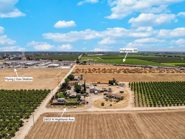
1603 N Highland Ave, Ripon, CA 95366


NEARBY LISTINGS FOR SALE OR LEASE
Property Detail
1603 N Highland Ave
228-110-08
REDRAWN JAN-03-2002 FROM ORIGINAL APN 243-320-13
Sfr
San Joaquin
X
California
06077C0645F
9.97 AC
2025
Tracy/Manteca
2025
Stockton/Modesto
005003
Stockton-Lodi, CA
2,012 SF
DEMOGRAPHICS near 1603 N Highland Ave
1 mile
3 mile
5 mile
2024 Total Population
615
23,901
70,811
2029 Population
652
25,247
74,346
Pop Growth 2024-2029
+ 6.02%
+ 5.63%
+ 4.99%
Average Age
38
38
38
2024 Total Households
221
7,890
22,794
HH Growth 2024-2029
+ 5.88%
+ 5.54%
+ 5.02%
Median Household Inc
$114,583
$114,559
$90,712
Avg Household Size
2.80
3.00
3.10
2024 Avg HH Vehicles
3.00
2.00
2.00
Median Home Value
$712,389
$676,621
$497,629
Median Year Built
2008
1999
1993
Nearby Places
Map Layers
Map Styles
 Street
 Aerial
Transit
 Traffic
 Biking
Places
Listings with unknown addresses are not visible on the map
- Restaurants
- Banks
- Shops
- Fitness
- Groceries
PUBLIC TRANSPORTATION
COMMUTER RAIL
Lathrop/Manteca (ACE Train - Altamont Commuter Express (ACE), Altamont Corridor Express - Altamont Commuter Express (ACE))
Drive
Walk
Distance
Lathrop/Manteca (ACE Train - Altamont Commuter Express (ACE), Altamont Corridor Express - Altamont Commuter Express (ACE))
16 min
9.5 mi
AIRPORT
Stockton Metro
Drive
Walk
Distance
Stockton Metro
21 min
14.0 mi
Freight Ports
Port of Stockton
Drive
Walk
Distance
Port of Stockton
30 min
22.5 mi
SALE & LEASE HISTORY
LISTING DATE
SALE/LEASE

Jun 16, 2023
For Sale
Nearby Properties
Address
Land Use
TOTAL SIZE
Lot Size
Zoning
Address
Land Use
TOTAL SIZE
Lot Size
Zoning
25,000 SF
131.14 AC
Address
Land Use
TOTAL SIZE
Lot Size
Zoning
7,812 SF
6.13 AC
CC
Address
Land Use
TOTAL SIZE
Lot Size
Zoning
66.42 AC
AU20
Address
Land Use
TOTAL SIZE
Lot Size
Zoning
7,590 SF
3.51 AC
Address
Land Use
TOTAL SIZE
Lot Size
Zoning
4.36 AC
Address
Land Use
TOTAL SIZE
Lot Size
Zoning
1,026 SF
36.52 AC
Address
Land Use
TOTAL SIZE
Lot Size
Zoning
1,052 SF
360.20 AC
A240
Address
Land Use
TOTAL SIZE
Lot Size
Zoning
6,450 SF
17.97 AC
Address
Land Use
TOTAL SIZE
Lot Size
Zoning
8.27 AC
Address
Land Use
TOTAL SIZE
Lot Size
Zoning
7.82 AC
Address
Land Use
TOTAL SIZE
Lot Size
Zoning
24,995 SF
9.81 AC
MX
Address
Land Use
TOTAL SIZE
Lot Size
Zoning
15,325 SF
16.91 AC
Address
Land Use
TOTAL SIZE
Lot Size
Zoning
9,238 SF
8.68 AC
Address
Land Use
TOTAL SIZE
Lot Size
Zoning
2.44 AC
R3
Address
Land Use
TOTAL SIZE
Lot Size
Zoning
9,135 SF
2.06 AC
Address
Land Use
TOTAL SIZE
Lot Size
Zoning
35,414 SF
4 AC
Address
Land Use
TOTAL SIZE
Lot Size
Zoning
16,150 SF
104.09 AC
AG40
Address
Land Use
TOTAL SIZE
Lot Size
Zoning
28,160 SF
6.23 AC
Address
Land Use
TOTAL SIZE
Lot Size
Zoning
28.45 AC
IW
Address
Land Use
TOTAL SIZE
Lot Size
Zoning
2.18 AC
Address
Land Use
TOTAL SIZE
Lot Size
Zoning
9,900 SF
6 AC
Address
Land Use
TOTAL SIZE
Lot Size
Zoning
1.56 AC
Address
Land Use
TOTAL SIZE
Lot Size
Zoning
21,782 SF
4.56 AC
Address
Land Use
TOTAL SIZE
Lot Size
Zoning
7.24 AC
Address
Land Use
TOTAL SIZE
Lot Size
Zoning
51,742 SF
4.82 AC
Address
Land Use
TOTAL SIZE
Lot Size
Zoning
3.09 AC
Address
Land Use
TOTAL SIZE
Lot Size
Zoning
14,739 SF
1.60 AC
Address
Land Use
TOTAL SIZE
Lot Size
Zoning
7.77 AC
Address
Land Use
TOTAL SIZE
Lot Size
Zoning
9,600 SF
2.40 AC
CG
Address
Land Use
TOTAL SIZE
Lot Size
Zoning
18.78 AC
The World's #1 Commercial Real Estate Marketplace
Connect with us
© 2026 CoStar Group
The information above has been obtained from sources believed reliable. While we do not doubt its accuracy we have not verified it and make no guarantee, warranty or representation about it. It is your responsibility to independently confirm its accuracy and completeness. Any projections, opinions, assumptions, or estimates used are for example only and do not represent the current or future performance of the property. The value of this transaction to you depends on tax and other factors which should be evaluated by your tax, financial, and legal advisors. You and your advisors should conduct a careful, independent investigation of the property to determine to your satisfaction the suitability of the property for your needs.