Property Record
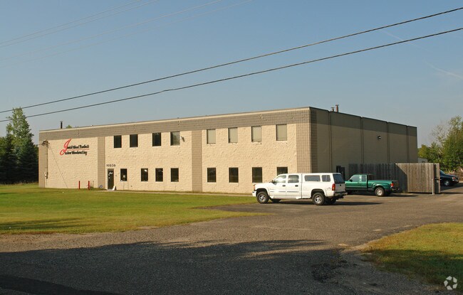
16030 Central Ave Ne, Andover, MN 55304


NEARBY LISTINGS FOR SALE OR LEASE
Property Detail
16030 Central Ave Ne
Minneapolis-St. Paul-Bloomington, MN-WI
Ham Lake Industrial Park 4Th Addition
17-32-23-31-0005
LOT 1 BLOCK 1 HAM LAKE INDUSTRIAL PARK 4TH ADD , EX RD SUBJ TO EASE OF REC
Industrialgeneral
Anoka
A
Minnesota
27003C0215E
1
2025
4.48 AC
2025
North Central
050235
Minneapolis/St Paul
17,800 SF
DEMOGRAPHICS near 16030 Central Ave Ne
1 Mile
3 Mile
5 Mile
2024 Total Population
1,215
16,139
61,052
2029 Population
1,260
16,816
63,603
Pop Growth 2024-2029
+ 3.70%
+ 4.19%
+ 4.18%
Average Age
40
40
39
2024 Total Households
437
5,510
20,655
HH Growth 2024-2029
+ 3.66%
+ 4.21%
+ 4.12%
Median Household Inc
$112,755
$113,824
$117,170
Avg Household Size
2.80
2.90
2.90
2024 Avg HH Vehicles
3.00
3.00
2.00
Median Home Value
$375,520
$385,960
$367,012
Median Year Built
1988
1993
1994
Nearby Places
Map Layers
Map Styles
 Street
 Aerial
- Restaurants
- Banks
- Shops
- Fitness
- Groceries
PUBLIC TRANSPORTATION
COMMUTER RAIL
Coon Rapids-Riverdale Station (Northstar Corridor - Northstar Commuter Rail)
DRIVE
WALK
Distance
Coon Rapids-Riverdale Station (Northstar Corridor - Northstar Commuter Rail)
17 min
10.0 mi
AIRPORT
Minneapolis-St Paul International/Wold-Chamberlain
DRIVE
WALK
Distance
Minneapolis-St Paul International/Wold-Chamberlain
47 min
32.4 mi
Freight Ports
Port Milwaukee
DRIVE
WALK
Distance
Port Milwaukee
392 min
354.5 mi
Nearby Properties
Address
Land Use
TOTAL SIZE
Lot Size
Zoning
Address
Land Use
TOTAL SIZE
Lot Size
Zoning
5.98 AC
Address
Land Use
TOTAL SIZE
Lot Size
Zoning
70,304 SF
Address
Land Use
TOTAL SIZE
Lot Size
Zoning
Address
Land Use
TOTAL SIZE
Lot Size
Zoning
53,180 SF
30.46 AC
Address
Land Use
TOTAL SIZE
Lot Size
Zoning
58,977 SF
5.65 AC
Address
Land Use
TOTAL SIZE
Lot Size
Zoning
55,932 SF
5.39 AC
Address
Land Use
TOTAL SIZE
Lot Size
Zoning
28,600 SF
4.37 AC
Address
Land Use
TOTAL SIZE
Lot Size
Zoning
24,000 SF
Address
Land Use
TOTAL SIZE
Lot Size
Zoning
1,182 SF
20.50 AC
Address
Land Use
TOTAL SIZE
Lot Size
Zoning
34,970 SF
202.94 AC
Address
Land Use
TOTAL SIZE
Lot Size
Zoning
32,000 SF
5.25 AC
Address
Land Use
TOTAL SIZE
Lot Size
Zoning
62,624 SF
12 AC
Address
Land Use
TOTAL SIZE
Lot Size
Zoning
1,120 SF
6.02 AC
Address
Land Use
TOTAL SIZE
Lot Size
Zoning
Address
Land Use
TOTAL SIZE
Lot Size
Zoning
33,992 SF
2.24 AC
Address
Land Use
TOTAL SIZE
Lot Size
Zoning
37,048 SF
2.58 AC
Address
Land Use
TOTAL SIZE
Lot Size
Zoning
36,159 SF
3.96 AC
Address
Land Use
TOTAL SIZE
Lot Size
Zoning
26,900 SF
7.08 AC
Address
Land Use
TOTAL SIZE
Lot Size
Zoning
40,310 SF
1.05 AC
Address
Land Use
TOTAL SIZE
Lot Size
Zoning
19,557 SF
21.93 AC
Address
Land Use
TOTAL SIZE
Lot Size
Zoning
9,766 SF
67.67 AC
Address
Land Use
TOTAL SIZE
Lot Size
Zoning
3,000 SF
12.75 AC
Address
Land Use
TOTAL SIZE
Lot Size
Zoning
23,920 SF
2.83 AC
Address
Land Use
TOTAL SIZE
Lot Size
Zoning
25,569 SF
2.20 AC
Address
Land Use
TOTAL SIZE
Lot Size
Zoning
17,100 SF
2.09 AC
Address
Land Use
TOTAL SIZE
Lot Size
Zoning
17,894 SF
1.82 AC
Address
Land Use
TOTAL SIZE
Lot Size
Zoning
29,618 SF
1.20 AC
Address
Land Use
TOTAL SIZE
Lot Size
Zoning
19,792 SF
2 AC
Address
Land Use
TOTAL SIZE
Lot Size
Zoning
35,200 SF
3.70 AC
The World's #1 Commercial Real Estate Marketplace
Connect with us
© 2026 CoStar Group
The information above has been obtained from sources believed reliable. While we do not doubt its accuracy we have not verified it and make no guarantee, warranty or representation about it. It is your responsibility to independently confirm its accuracy and completeness. Any projections, opinions, assumptions, or estimates used are for example only and do not represent the current or future performance of the property. The value of this transaction to you depends on tax and other factors which should be evaluated by your tax, financial, and legal advisors. You and your advisors should conduct a careful, independent investigation of the property to determine to your satisfaction the suitability of the property for your needs.