Property Record
16033 E State Highway 29, Buchanan Dam, TX 78609

Save to a Folder
{{folder.Name}}
{{folder.ListingIds.length}} Properties
{{folder.ListingIds.length}} Property
Create a New Folder
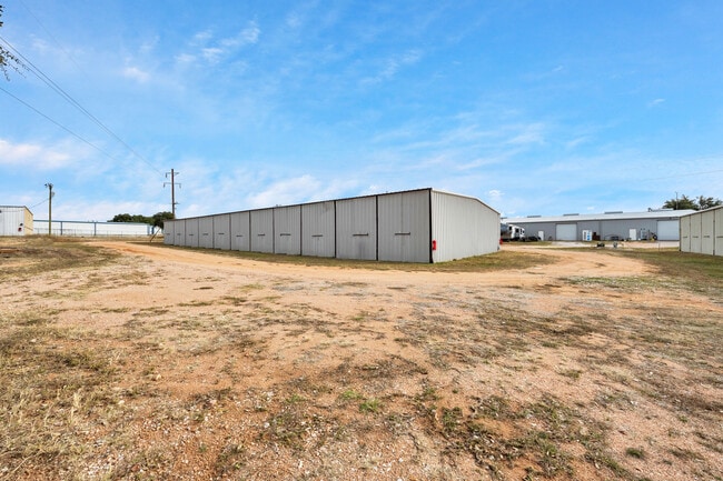
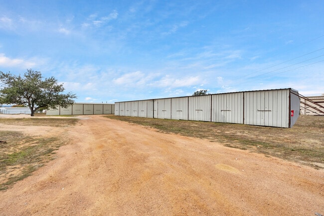
Property Detail
16033 E State Highway 29
16913
INDIAN HILLS LTS 189-194
Commercialnec
LLANO
B and X Area of moderate flood hazard, usually the area between the limits of the 100-year and 500-year floods.
Texas
2025
189-194
2025
1.36 AC
970600
Buchanan Lake
18,750 SF
Other Market Areas
NEARBY LISTINGS FOR SALE OR LEASE
-
-
View all Buchanan Dam listings for sale on LoopNet.com
DEMOGRAPHICS near 16033 E State Highway 29
1 mile
3 mile
5 mile
2025 Total Population
539
1,505
8,377
2030 Population
565
1,570
9,075
Pop Growth 2025-2030
+ 4.82%
+ 4.32%
+ 8.33%
Average Age
54
53
49
2025 Total Households
271
741
3,675
HH Growth 2025-2030
+ 4.80%
+ 4.18%
+ 8.22%
Median Household Inc
$63,851
$65,866
$66,290
Avg Household Size
1.90
2.00
2.20
2025 Avg HH Vehicles
2.00
2.00
2.00
Median Home Value
$362,499
$331,538
$354,501
Median Year Built
1987
1987
1994
Nearby Places
Map Layers
Map Styles
 Street
 Aerial
Layers
 Traffic
 Biking
Places
Listings with unknown addresses are not visible on the map
- Restaurants
- Banks
- Shops
- Fitness
- Groceries
SALE & LEASE HISTORY
LISTING DATE
SALE/LEASE

Dec 19, 2024
For Sale
Nearby Properties
Address
Land Use
TOTAL SIZE
Lot Size
Zoning
Address
Land Use
TOTAL SIZE
Lot Size
Zoning
4,200 SF
0.92 AC
Address
Land Use
TOTAL SIZE
Lot Size
Zoning
3,318 SF
4.62 AC
Address
Land Use
TOTAL SIZE
Lot Size
Zoning
14,004 SF
8 AC
Address
Land Use
TOTAL SIZE
Lot Size
Zoning
18,839 SF
1.98 AC
Address
Land Use
TOTAL SIZE
Lot Size
Zoning
594 SF
1.47 AC
Address
Land Use
TOTAL SIZE
Lot Size
Zoning
47,160 SF
7.59 AC
Address
Land Use
TOTAL SIZE
Lot Size
Zoning
9.09 AC
Address
Land Use
TOTAL SIZE
Lot Size
Zoning
1,792 SF
8.67 AC
Address
Land Use
TOTAL SIZE
Lot Size
Zoning
87 SF
Address
Land Use
TOTAL SIZE
Lot Size
Zoning
12,416 SF
1.96 AC
Address
Land Use
TOTAL SIZE
Lot Size
Zoning
6,268 SF
0.73 AC
Address
Land Use
TOTAL SIZE
Lot Size
Zoning
2,928 SF
1.26 AC
Address
Land Use
TOTAL SIZE
Lot Size
Zoning
2,376 SF
13.13 AC
Address
Land Use
TOTAL SIZE
Lot Size
Zoning
2,635 SF
6.96 AC
Address
Land Use
TOTAL SIZE
Lot Size
Zoning
8,072 SF
3.15 AC
Address
Land Use
TOTAL SIZE
Lot Size
Zoning
525 SF
6.17 AC
Address
Land Use
TOTAL SIZE
Lot Size
Zoning
10,024 SF
2.51 AC
Address
Land Use
TOTAL SIZE
Lot Size
Zoning
984 SF
0.44 AC
Address
Land Use
TOTAL SIZE
Lot Size
Zoning
Address
Land Use
TOTAL SIZE
Lot Size
Zoning
9,016 SF
1.76 AC
Address
Land Use
TOTAL SIZE
Lot Size
Zoning
7,692 SF
6 AC
Address
Land Use
TOTAL SIZE
Lot Size
Zoning
7,200 SF
4.03 AC
Address
Land Use
TOTAL SIZE
Lot Size
Zoning
2,276 SF
0.50 AC
Address
Land Use
TOTAL SIZE
Lot Size
Zoning
399 SF
3.10 AC
Address
Land Use
TOTAL SIZE
Lot Size
Zoning
1,008 SF
1.81 AC
Address
Land Use
TOTAL SIZE
Lot Size
Zoning
3,281 SF
0.79 AC
Address
Land Use
TOTAL SIZE
Lot Size
Zoning
2,145 SF
1.05 AC
Address
Land Use
TOTAL SIZE
Lot Size
Zoning
1,772 SF
2.33 AC
Address
Land Use
TOTAL SIZE
Lot Size
Zoning
14,400 SF
0.89 AC
Address
Land Use
TOTAL SIZE
Lot Size
Zoning
5,179 SF
2.18 AC
The World's #1 Commercial Real Estate Marketplace
Connect with us
© 2026 CoStar Group
The information above has been obtained from sources believed reliable. While we do not doubt its accuracy we have not verified it and make no guarantee, warranty or representation about it. It is your responsibility to independently confirm its accuracy and completeness. Any projections, opinions, assumptions, or estimates used are for example only and do not represent the current or future performance of the property. The value of this transaction to you depends on tax and other factors which should be evaluated by your tax, financial, and legal advisors. You and your advisors should conduct a careful, independent investigation of the property to determine to your satisfaction the suitability of the property for your needs.