Property Record
1605 Division St, Mendota, IL 61342
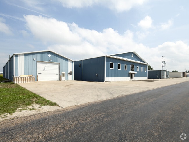

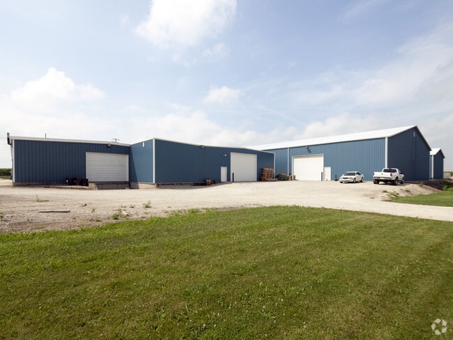
Property Detail
1605 Division St
Ottawa, IL
ENDERS INC SUB, LTS 1, 2 & 3 SEC 32-36-1
01-32-425005
LA SALLE
Industrialgeneral
Illinois
B and X Area of moderate flood hazard, usually the area between the limits of the 100-year and 500-year floods.
1-3
2024
1.87 AC
2025
I-39 Cor/LaSalle Cnty
961900
Chicago
28,959 SF
NEARBY LISTINGS FOR SALE OR LEASE
DEMOGRAPHICS near 1605 Division St
1 mile
3 mile
5 mile
2025 Total Population
3,001
7,438
7,876
2030 Population
2,954
7,328
7,754
Pop Growth 2025-2030
(1.57%)
(1.48%)
(1.55%)
Average Age
41
41
41
2025 Total Households
1,231
2,957
3,136
HH Growth 2025-2030
(1.62%)
(1.59%)
(1.66%)
Median Household Inc
$59,499
$64,346
$65,650
Avg Household Size
2.40
2.40
2.40
2025 Avg HH Vehicles
2.00
2.00
2.00
Median Home Value
$145,302
$146,078
$147,548
Median Year Built
1959
1959
1958
Nearby Places
Map Layers
Map Styles
 Street
 Aerial
Layers
 Traffic
 Biking
Places
Listings with unknown addresses are not visible on the map
- Restaurants
- Banks
- Shops
- Fitness
- Groceries
PUBLIC TRANSPORTATION
COMMUTER RAIL
Mendota Amtrak Station (Carl Sandburg - Amtrak, Illinois Zephyr - Amtrak, Southwest Chief - Amtrak)
Drive
Walk
Distance
Mendota Amtrak Station (Carl Sandburg - Amtrak, Illinois Zephyr - Amtrak, Southwest Chief - Amtrak)
3 min
1.5 mi
Freight Ports
Port Milwaukee
Drive
Walk
Distance
Port Milwaukee
168 min
146.0 mi
Nearby Properties
Address
Land Use
TOTAL SIZE
Lot Size
Zoning
Address
Land Use
TOTAL SIZE
Lot Size
Zoning
37.10 AC
Address
Land Use
TOTAL SIZE
Lot Size
Zoning
245,030 SF
14.36 AC
Address
Land Use
TOTAL SIZE
Lot Size
Zoning
202,418 SF
15.50 AC
Address
Land Use
TOTAL SIZE
Lot Size
Zoning
27,741 SF
5.98 AC
Address
Land Use
TOTAL SIZE
Lot Size
Zoning
149,296 SF
19.53 AC
Address
Land Use
TOTAL SIZE
Lot Size
Zoning
90,000 SF
19.30 AC
Address
Land Use
TOTAL SIZE
Lot Size
Zoning
9,000 SF
12.82 AC
Address
Land Use
TOTAL SIZE
Lot Size
Zoning
92,574 SF
14.32 AC
Address
Land Use
TOTAL SIZE
Lot Size
Zoning
1.70 AC
Address
Land Use
TOTAL SIZE
Lot Size
Zoning
60,473 SF
16.58 AC
Address
Land Use
TOTAL SIZE
Lot Size
Zoning
50,650 SF
8.44 AC
Address
Land Use
TOTAL SIZE
Lot Size
Zoning
25,637 SF
9.09 AC
Address
Land Use
TOTAL SIZE
Lot Size
Zoning
2.03 AC
Address
Land Use
TOTAL SIZE
Lot Size
Zoning
1.75 AC
Address
Land Use
TOTAL SIZE
Lot Size
Zoning
0.58 AC
Address
Land Use
TOTAL SIZE
Lot Size
Zoning
0.38 AC
Address
Land Use
TOTAL SIZE
Lot Size
Zoning
3,432 SF
3.32 AC
Address
Land Use
TOTAL SIZE
Lot Size
Zoning
36,500 SF
15.03 AC
Address
Land Use
TOTAL SIZE
Lot Size
Zoning
11,628 SF
0.32 AC
Address
Land Use
TOTAL SIZE
Lot Size
Zoning
24,894 SF
8.34 AC
Address
Land Use
TOTAL SIZE
Lot Size
Zoning
13,575 SF
1.68 AC
Address
Land Use
TOTAL SIZE
Lot Size
Zoning
12,784 SF
2.36 AC
Address
Land Use
TOTAL SIZE
Lot Size
Zoning
4,200 SF
1.26 AC
Address
Land Use
TOTAL SIZE
Lot Size
Zoning
32,000 SF
1.83 AC
Address
Land Use
TOTAL SIZE
Lot Size
Zoning
29,400 SF
1.71 AC
Address
Land Use
TOTAL SIZE
Lot Size
Zoning
5,506 SF
0.85 AC
Address
Land Use
TOTAL SIZE
Lot Size
Zoning
Address
Land Use
TOTAL SIZE
Lot Size
Zoning
1,890 SF
8.37 AC
Address
Land Use
TOTAL SIZE
Lot Size
Zoning
7,440 SF
1.14 AC
Address
Land Use
TOTAL SIZE
Lot Size
Zoning
10,640 SF
1.37 AC
The World's #1 Commercial Real Estate Marketplace
Connect with us
© 2026 CoStar Group
The information above has been obtained from sources believed reliable. While we do not doubt its accuracy we have not verified it and make no guarantee, warranty or representation about it. It is your responsibility to independently confirm its accuracy and completeness. Any projections, opinions, assumptions, or estimates used are for example only and do not represent the current or future performance of the property. The value of this transaction to you depends on tax and other factors which should be evaluated by your tax, financial, and legal advisors. You and your advisors should conduct a careful, independent investigation of the property to determine to your satisfaction the suitability of the property for your needs.