Property Record
1605 E Pershing Rd, Decatur, IL 62526

Property Detail
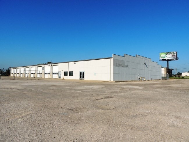
1605 E Pershing Rd
Decatur, IL
NW4 NW4 T16N R02E
04-12-01-101-002
Macon
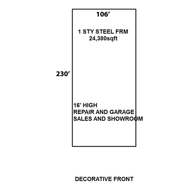
Autorepair
Illinois
MUNICIPAL
1,2
B and X Area of moderate flood hazard, usually the area between the limits of the 100-year and 500-year floods.
5.17 AC
2024
Springfield/Decatur
2024
Other Market Areas
002100
NEARBY LISTINGS FOR SALE OR LEASE
DEMOGRAPHICS near 1605 E Pershing Rd
1 mile
3 mile
5 mile
2025 Total Population
3,759
43,333
72,947
2030 Population
3,723
43,057
71,942
Pop Growth 2025-2030
(0.96%)
(0.64%)
(1.38%)
Average Age
40
40
41
2025 Total Households
1,975
19,178
31,738
HH Growth 2025-2030
(0.71%)
(0.74%)
(1.46%)
Median Household Inc
$27,624
$41,473
$48,271
Avg Household Size
1.90
2.10
2.10
2025 Avg HH Vehicles
1.00
1.00
2.00
Median Home Value
$64,502
$74,928
$94,593
Median Year Built
1974
1959
1961
Nearby Places
Map Layers
Map Styles
 Street
 Aerial
Transit
 Traffic
 Biking
Places
Listings with unknown addresses are not visible on the map
- Restaurants
- Banks
- Shops
- Fitness
- Groceries
PUBLIC TRANSPORTATION
AIRPORT
University of Illinois/Willard
Drive
Walk
Distance
University of Illinois/Willard
60 min
47.3 mi
SALE & LEASE HISTORY
LISTING DATE
SALE/LEASE

Sep 26, 2016
For Lease
Jul 09, 2019
For Lease
Nearby Properties
Address
Land Use
TOTAL SIZE
Lot Size
Zoning
Address
Land Use
TOTAL SIZE
Lot Size
Zoning
10 AC
MUNICIPAL
Address
Land Use
TOTAL SIZE
Lot Size
Zoning
38.36 AC
MUNICIPAL
Address
Land Use
TOTAL SIZE
Lot Size
Zoning
87.31 AC
MUNICIPAL
Address
Land Use
TOTAL SIZE
Lot Size
Zoning
107.54 AC
MUNICIPAL
Address
Land Use
TOTAL SIZE
Lot Size
Zoning
76.02 AC
MUNICIPAL
Address
Land Use
TOTAL SIZE
Lot Size
Zoning
68.23 AC
MUNICIPAL
Address
Land Use
TOTAL SIZE
Lot Size
Zoning
12.21 AC
MUNICIPAL
Address
Land Use
TOTAL SIZE
Lot Size
Zoning
1.03 AC
MUNICIPAL
Address
Land Use
TOTAL SIZE
Lot Size
Zoning
13.75 AC
MUNICIPAL
Address
Land Use
TOTAL SIZE
Lot Size
Zoning
207,420 SF
12.41 AC
MUNICIPAL
Address
Land Use
TOTAL SIZE
Lot Size
Zoning
1.40 AC
MUNICIPAL
Address
Land Use
TOTAL SIZE
Lot Size
Zoning
6.60 AC
MUNICIPAL
Address
Land Use
TOTAL SIZE
Lot Size
Zoning
1,604 SF
12.80 AC
MUNICIPAL
Address
Land Use
TOTAL SIZE
Lot Size
Zoning
3.88 AC
MUNICIPAL
Address
Land Use
TOTAL SIZE
Lot Size
Zoning
17.82 AC
MUNICIPAL
Address
Land Use
TOTAL SIZE
Lot Size
Zoning
13.92 AC
MUNICIPAL
Address
Land Use
TOTAL SIZE
Lot Size
Zoning
12.24 AC
MUNICIPAL
Address
Land Use
TOTAL SIZE
Lot Size
Zoning
6.68 AC
MUNICIPAL
Address
Land Use
TOTAL SIZE
Lot Size
Zoning
23.56 AC
MUNICIPAL
Address
Land Use
TOTAL SIZE
Lot Size
Zoning
18.50 AC
MUNICIPAL
Address
Land Use
TOTAL SIZE
Lot Size
Zoning
6.89 AC
MUNICIPAL
Address
Land Use
TOTAL SIZE
Lot Size
Zoning
19.95 AC
MUNICIPAL
Address
Land Use
TOTAL SIZE
Lot Size
Zoning
7.82 AC
MUNICIPAL
Address
Land Use
TOTAL SIZE
Lot Size
Zoning
3.35 AC
MUNICIPAL
Address
Land Use
TOTAL SIZE
Lot Size
Zoning
3.55 AC
MUNICIPAL
Address
Land Use
TOTAL SIZE
Lot Size
Zoning
14.66 AC
MUNICIPAL
Address
Land Use
TOTAL SIZE
Lot Size
Zoning
13.04 AC
MUNICIPAL
Address
Land Use
TOTAL SIZE
Lot Size
Zoning
20 AC
MUNICIPAL
Address
Land Use
TOTAL SIZE
Lot Size
Zoning
25.59 AC
MUNICIPAL
The World's #1 Commercial Real Estate Marketplace
Connect with us
© 2026 CoStar Group
The information above has been obtained from sources believed reliable. While we do not doubt its accuracy we have not verified it and make no guarantee, warranty or representation about it. It is your responsibility to independently confirm its accuracy and completeness. Any projections, opinions, assumptions, or estimates used are for example only and do not represent the current or future performance of the property. The value of this transaction to you depends on tax and other factors which should be evaluated by your tax, financial, and legal advisors. You and your advisors should conduct a careful, independent investigation of the property to determine to your satisfaction the suitability of the property for your needs.