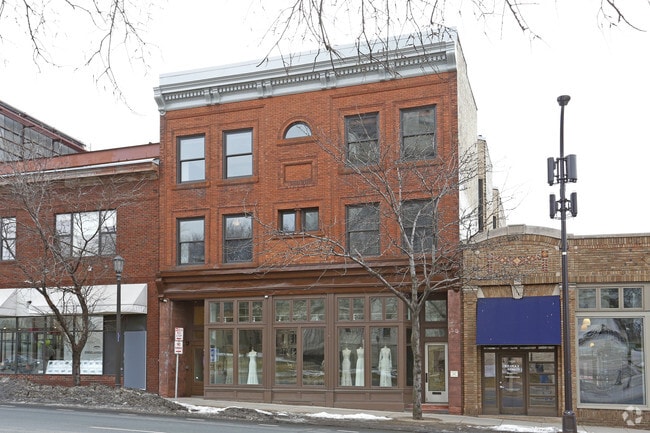
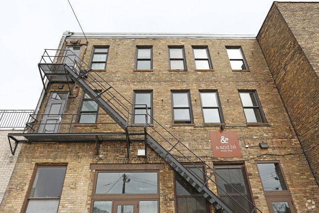
Property Record
1605 Hennepin Ave, Minneapolis, MN 55403
Current Lease Availabilities
NEARBY LISTINGS FOR SALE OR LEASE
Property Detail
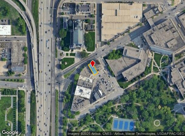
1605 Hennepin Ave
Minneapolis-St. Paul-Bloomington, MN-WI
The Washington Yale Addn To Mpls
27-029-24-23-0030
Hennepin
Triplex
Minnesota
X
0.10 AC
27053C0356F
Loring Park
10,560 SF
Minneapolis/St Paul
DEMOGRAPHICS near 1605 Hennepin Ave
1 Mile
3 Mile
5 Mile
2024 Total Population
36,890
248,755
482,257
2029 Population
36,830
245,771
474,690
Pop Growth 2024-2029
(0.16%)
(1.20%)
(1.57%)
Average Age
38
35
37
2024 Total Households
22,653
114,361
213,945
HH Growth 2024-2029
(0.13%)
(1.04%)
(1.51%)
Median Household Inc
$54,284
$62,262
$71,968
Avg Household Size
1.50
2.00
2.10
2024 Avg HH Vehicles
1.00
1.00
1.00
Median Home Value
$360,956
$347,091
$340,041
Median Year Built
1969
1967
1957
Nearby Places
- Restaurants
- Banks
- Shops
- Fitness
- Groceries
PUBLIC TRANSPORTATION
TRANSIT/SUBWAY
Warehouse District/Hennepin Avenue Station (Hiawatha Line - Minneapolis-Saint Paul Metro Transit Light Rail)
DRIVE
WALK
Distance
Warehouse District/Hennepin Avenue Station (Hiawatha Line - Minneapolis-Saint Paul Metro Transit Light Rail)
2 min
16 min
0.9 mi
Nicollet Mall Station (Hiawatha Line - Minneapolis-Saint Paul Metro Transit Light Rail)
DRIVE
WALK
Distance
Nicollet Mall Station (Hiawatha Line - Minneapolis-Saint Paul Metro Transit Light Rail)
3 min
18 min
1.0 mi
Target Field Station Platform 2 (METRO Blue Line - Metro Transit, METRO Green Line - Metro Transit)
DRIVE
WALK
Distance
Target Field Station Platform 2 (METRO Blue Line - Metro Transit, METRO Green Line - Metro Transit)
4 min
20 min
1.1 mi
Target Field Station (Hiawatha Line - Minneapolis-Saint Paul Metro Transit Light Rail)
DRIVE
WALK
Distance
Target Field Station (Hiawatha Line - Minneapolis-Saint Paul Metro Transit Light Rail)
3 min
20 min
1.1 mi
COMMUTER RAIL
Target Field Station (Northstar Corridor - Northstar Commuter Rail)
DRIVE
WALK
Distance
Target Field Station (Northstar Corridor - Northstar Commuter Rail)
4 min
1.3 mi
Fridley Station (Northstar Corridor - Northstar Commuter Rail)
DRIVE
WALK
Distance
Fridley Station (Northstar Corridor - Northstar Commuter Rail)
15 min
8.9 mi
AIRPORT
Minneapolis-St Paul International/Wold-Chamberlain
DRIVE
WALK
Distance
Minneapolis-St Paul International/Wold-Chamberlain
23 min
13.1 mi
Freight Ports
Port Milwaukee
DRIVE
WALK
Distance
Port Milwaukee
378 min
339.8 mi
Nearby Properties
Address
Land Use
TOTAL SIZE
Lot Size
Zoning
Address
Land Use
TOTAL SIZE
Lot Size
Zoning
1,462,182 SF
1 AC
B4-2
Address
Land Use
TOTAL SIZE
Lot Size
Zoning
2,094,377 SF
2.10 AC
B4-2
Address
Land Use
TOTAL SIZE
Lot Size
Zoning
1,821,999 SF
2.51 AC
B4-2
Address
Land Use
TOTAL SIZE
Lot Size
Zoning
Address
Land Use
TOTAL SIZE
Lot Size
Zoning
1,934,403 SF
1.67 AC
B4-2
Address
Land Use
TOTAL SIZE
Lot Size
Zoning
1,021,060 SF
1.71 AC
B4S-2
Address
Land Use
TOTAL SIZE
Lot Size
Zoning
2,282,334 SF
3.25 AC
B4-2
Address
Land Use
TOTAL SIZE
Lot Size
Zoning
1,054,492 SF
1.70 AC
B4-1
Address
Land Use
TOTAL SIZE
Lot Size
Zoning
495,632 SF
1.72 AC
C1
Address
Land Use
TOTAL SIZE
Lot Size
Zoning
1,208,190 SF
1.20 AC
B4-2
Address
Land Use
TOTAL SIZE
Lot Size
Zoning
621,608 SF
1.03 AC
B4-2
Address
Land Use
TOTAL SIZE
Lot Size
Zoning
458,470 SF
1.18 AC
OR3
Address
Land Use
TOTAL SIZE
Lot Size
Zoning
907,129 SF
1.65 AC
B4-1
Address
Land Use
TOTAL SIZE
Lot Size
Zoning
Address
Land Use
TOTAL SIZE
Lot Size
Zoning
442,731 SF
0.97 AC
B4S-2
Address
Land Use
TOTAL SIZE
Lot Size
Zoning
1,044,454 SF
1.08 AC
B4-2
Address
Land Use
TOTAL SIZE
Lot Size
Zoning
1,261,574 SF
2.52 AC
B4-2
Address
Land Use
TOTAL SIZE
Lot Size
Zoning
695,624 SF
3.67 AC
C2
Address
Land Use
TOTAL SIZE
Lot Size
Zoning
2.67 AC
C3A
Address
Land Use
TOTAL SIZE
Lot Size
Zoning
615,172 SF
1.98 AC
I1
Address
Land Use
TOTAL SIZE
Lot Size
Zoning
275,782 SF
2.40 AC
C3A
Address
Land Use
TOTAL SIZE
Lot Size
Zoning
659,076 SF
1.45 AC
C3A
Address
Land Use
TOTAL SIZE
Lot Size
Zoning
722,423 SF
1.33 AC
B4-2
Address
Land Use
TOTAL SIZE
Lot Size
Zoning
1,424,796 SF
1.13 AC
B4-1
Address
Land Use
TOTAL SIZE
Lot Size
Zoning
557,654 SF
3.15 AC
C2
Address
Land Use
TOTAL SIZE
Lot Size
Zoning
3,008,334 SF
7.72 AC
Address
Land Use
TOTAL SIZE
Lot Size
Zoning
478,616 SF
2.28 AC
C2
Address
Land Use
TOTAL SIZE
Lot Size
Zoning
Address
Land Use
TOTAL SIZE
Lot Size
Zoning
513,403 SF
0.73 AC
C2
Address
Land Use
TOTAL SIZE
Lot Size
Zoning
1,235,416 SF
1.12 AC
B4-2
The World's #1 Commercial Real Estate Marketplace
Connect with us
© 2025 CoStar Group
The information above has been obtained from sources believed reliable. While we do not doubt its accuracy we have not verified it and make no guarantee, warranty or representation about it. It is your responsibility to independently confirm its accuracy and completeness. Any projections, opinions, assumptions, or estimates used are for example only and do not represent the current or future performance of the property. The value of this transaction to you depends on tax and other factors which should be evaluated by your tax, financial, and legal advisors. You and your advisors should conduct a careful, independent investigation of the property to determine to your satisfaction the suitability of the property for your needs.