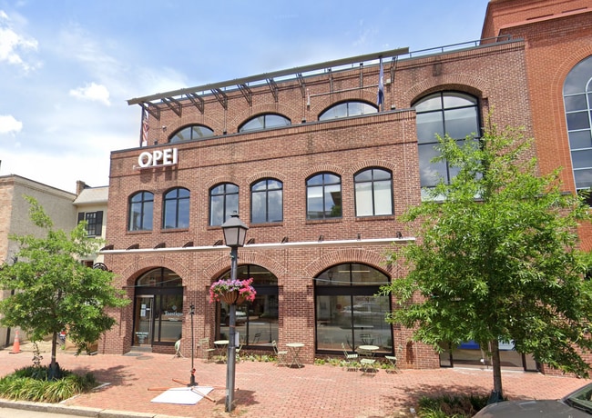
Property Record
1605 King St, Alexandria, VA 22314
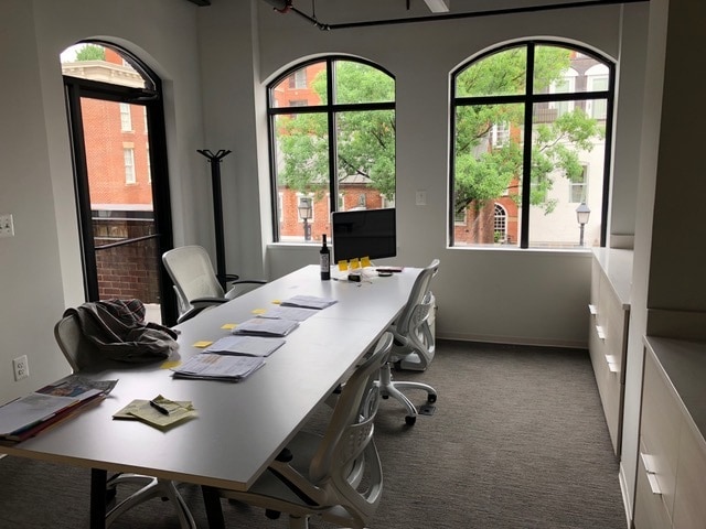

Current Lease Availabilities
NEARBY LISTINGS FOR SALE OR LEASE
Property Detail
1605 King St
063.04-0E-03
1605 King St Condominium
Officecondo
UNIT 3 1605 KING ST CONDOMINIUM
X
Alexandria
5155190041F
Virginia
2024
0.13 AC
2025
Old Town Alexandria
201900
Washington, DC
705 SF
Washington-Arlington-Alexandria, DC-VA-MD-WV
DEMOGRAPHICS near 1605 King St
1 Mile
3 Mile
5 Mile
2024 Total Population
32,862
148,177
462,740
2029 Population
31,994
144,317
451,523
Pop Growth 2024-2029
(2.64%)
(2.60%)
(2.42%)
Average Age
42
40
39
2024 Total Households
17,114
68,655
201,750
HH Growth 2024-2029
(2.62%)
(2.57%)
(2.45%)
Median Household Inc
$141,292
$120,436
$98,249
Avg Household Size
1.90
2.10
2.20
2024 Avg HH Vehicles
1.00
1.00
1.00
Median Home Value
$840,388
$694,917
$552,835
Median Year Built
1978
1971
1974
Nearby Places
- Restaurants
- Banks
- Shops
- Fitness
- Groceries
PUBLIC TRANSPORTATION
TRANSIT/SUBWAY
King Street (Blue Line - Washington Metropolitan Area Transit Authority Metrorail (Metrorail), Yellow Line - Washington Metropolitan Area Transit Authority Metrorail (Metrorail))
DRIVE
WALK
Distance
King Street (Blue Line - Washington Metropolitan Area Transit Authority Metrorail (Metrorail), Yellow Line - Washington Metropolitan Area Transit Authority Metrorail (Metrorail))
1 min
4 min
0.2 mi
Alexandria (Fredericksburg Line - Virginia Railway Express, Manassas Line - Virginia Railway Express)
DRIVE
WALK
Distance
Alexandria (Fredericksburg Line - Virginia Railway Express, Manassas Line - Virginia Railway Express)
2 min
7 min
0.4 mi
Braddock Road (Blue Line - Washington Metropolitan Area Transit Authority Metrorail (Metrorail), Yellow Line - Washington Metropolitan Area Transit Authority Metrorail (Metrorail))
DRIVE
WALK
Distance
Braddock Road (Blue Line - Washington Metropolitan Area Transit Authority Metrorail (Metrorail), Yellow Line - Washington Metropolitan Area Transit Authority Metrorail (Metrorail))
3 min
12 min
0.6 mi
COMMUTER RAIL
Alexandria (Fredericksburg Line - Virginia Railway Express, Manassas Line - Virginia Railway Express)
DRIVE
WALK
Distance
Alexandria (Fredericksburg Line - Virginia Railway Express, Manassas Line - Virginia Railway Express)
2 min
6 min
0.3 mi
DRIVE
WALK
Distance
2 min
7 min
0.3 mi
AIRPORT
Ronald Reagan Washington Ntl
DRIVE
WALK
Distance
Ronald Reagan Washington Ntl
12 min
4.5 mi
Washington Dulles International
DRIVE
WALK
Distance
Washington Dulles International
52 min
32.1 mi
Baltimore/Washington International Thurgood Marshall
DRIVE
WALK
Distance
Baltimore/Washington International Thurgood Marshall
62 min
39.1 mi
Freight Ports
Port of Baltimore
DRIVE
WALK
Distance
Port of Baltimore
71 min
46.1 mi
Nearby Properties
Address
Land Use
TOTAL SIZE
Lot Size
Zoning
Address
Land Use
TOTAL SIZE
Lot Size
Zoning
1,241,298 SF
11.53 AC
RTOLE
Address
Land Use
TOTAL SIZE
Lot Size
Zoning
2,308,874 SF
22.78 AC
RR
Address
Land Use
TOTAL SIZE
Lot Size
Zoning
1,719,751 SF
39.48 AC
PDR-3;UNZO
Address
Land Use
TOTAL SIZE
Lot Size
Zoning
75.49 AC
RA
Address
Land Use
TOTAL SIZE
Lot Size
Zoning
989,384 SF
5.17 AC
CDD#2
Address
Land Use
TOTAL SIZE
Lot Size
Zoning
1,931,127 SF
11.53 AC
RTOLE
Address
Land Use
TOTAL SIZE
Lot Size
Zoning
1,278,930 SF
28.17 AC
350
Address
Land Use
TOTAL SIZE
Lot Size
Zoning
6,370 SF
3.06 AC
RA6-15
Address
Land Use
TOTAL SIZE
Lot Size
Zoning
35.71 AC
P-S/RA8-18
Address
Land Use
TOTAL SIZE
Lot Size
Zoning
360,007 SF
35.80 AC
UT
Address
Land Use
TOTAL SIZE
Lot Size
Zoning
336,904 SF
2.12 AC
CDD#15
Address
Land Use
TOTAL SIZE
Lot Size
Zoning
782,494 SF
27.65 AC
R 12
Address
Land Use
TOTAL SIZE
Lot Size
Zoning
1,032,882 SF
CDD#20
Address
Land Use
TOTAL SIZE
Lot Size
Zoning
16,782 SF
1.67 AC
C-O-1.5
Address
Land Use
TOTAL SIZE
Lot Size
Zoning
608,495 SF
1.50 AC
CDD#2
Address
Land Use
TOTAL SIZE
Lot Size
Zoning
2 SF
2.03 AC
C-O-1.5
Address
Land Use
TOTAL SIZE
Lot Size
Zoning
1,178,900 SF
4.67 AC
CDD#1
Address
Land Use
TOTAL SIZE
Lot Size
Zoning
343,400 SF
12 AC
POS
Address
Land Use
TOTAL SIZE
Lot Size
Zoning
514,822 SF
44.64 AC
Address
Land Use
TOTAL SIZE
Lot Size
Zoning
559,357 SF
2.26 AC
CDD#2
Address
Land Use
TOTAL SIZE
Lot Size
Zoning
981,001 SF
2.24 AC
C-O
Address
Land Use
TOTAL SIZE
Lot Size
Zoning
4,143 SF
1.89 AC
C-O-1.5
Address
Land Use
TOTAL SIZE
Lot Size
Zoning
499,532 SF
3.04 AC
Address
Land Use
TOTAL SIZE
Lot Size
Zoning
694,318 SF
12.83 AC
CDD#7
Address
Land Use
TOTAL SIZE
Lot Size
Zoning
445,727 SF
12.82 AC
RC
Address
Land Use
TOTAL SIZE
Lot Size
Zoning
427,898 SF
1.88 AC
CDD#10
Address
Land Use
TOTAL SIZE
Lot Size
Zoning
166,800 SF
2.72 AC
CDD#1
Address
Land Use
TOTAL SIZE
Lot Size
Zoning
315,876 SF
1.55 AC
OCH
Address
Land Use
TOTAL SIZE
Lot Size
Zoning
7.04 AC
CDD#3
Address
Land Use
TOTAL SIZE
Lot Size
Zoning
5,015 SF
1.34 AC
C-O-1.5
The World's #1 Commercial Real Estate Marketplace
Connect with us
© 2025 CoStar Group
The information above has been obtained from sources believed reliable. While we do not doubt its accuracy we have not verified it and make no guarantee, warranty or representation about it. It is your responsibility to independently confirm its accuracy and completeness. Any projections, opinions, assumptions, or estimates used are for example only and do not represent the current or future performance of the property. The value of this transaction to you depends on tax and other factors which should be evaluated by your tax, financial, and legal advisors. You and your advisors should conduct a careful, independent investigation of the property to determine to your satisfaction the suitability of the property for your needs.