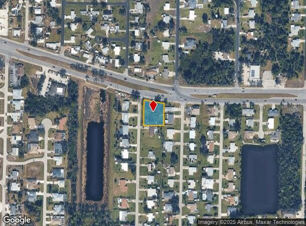
Property Record
1605 Mel-O-De Ln, Englewood, FL 34224
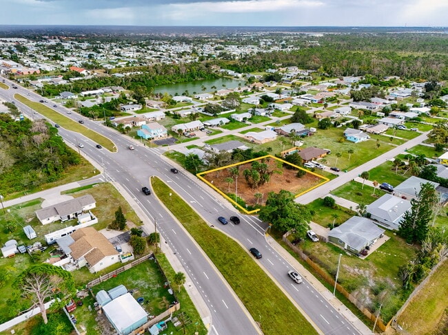
This Property Is For Sale
NEARBY LISTINGS FOR SALE OR LEASE
Property Detail
1605 Mel-O-De Ln
Punta Gorda, FL
Mel-O-De Lane
412005459002
MEL-O-DE LANE LTS 29 & 30 LESS R/W 605/1296 DC731/1355 867/1762 2322/851 2549/1996 3329001
Commercialacreage
Charlotte
AE
Florida
12015C0187G
29,30
2024
0.53 AC
2025
Charlotte County
030202
Southwest Florida
DEMOGRAPHICS near 1605 Mel-O-De Ln
1 Mile
3 Mile
5 Mile
2024 Total Population
5,591
25,153
47,727
2029 Population
6,821
30,300
57,323
Pop Growth 2024-2029
+ 22.00%
+ 20.46%
+ 20.11%
Average Age
62
59
58
2024 Total Households
2,965
12,878
24,073
HH Growth 2024-2029
+ 22.33%
+ 20.76%
+ 20.30%
Median Household Inc
$49,664
$55,607
$56,296
Avg Household Size
1.80
1.90
1.90
2024 Avg HH Vehicles
1.00
2.00
2.00
Median Home Value
$212,226
$265,613
$266,400
Median Year Built
1980
1984
1987
Nearby Places
Map Layers
Map Styles
 Street
 Aerial
- Restaurants
- Banks
- Shops
- Fitness
- Groceries
PUBLIC TRANSPORTATION
AIRPORT
Punta Gorda
DRIVE
WALK
Distance
Punta Gorda
44 min
27.0 mi
Freight Ports
Port Manatee
DRIVE
WALK
Distance
Port Manatee
76 min
56.2 mi
Nearby Properties
Address
Land Use
TOTAL SIZE
Lot Size
Zoning
Address
Land Use
TOTAL SIZE
Lot Size
Zoning
796,848 SF
44.28 AC
RE1
Address
Land Use
TOTAL SIZE
Lot Size
Zoning
95,649 SF
10.41 AC
OPI
Address
Land Use
TOTAL SIZE
Lot Size
Zoning
193,100 SF
26.30 AC
PD
Address
Land Use
TOTAL SIZE
Lot Size
Zoning
55,952 SF
4.69 AC
MMF7.5
Address
Land Use
TOTAL SIZE
Lot Size
Zoning
73,356 SF
8.98 AC
GU
Address
Land Use
TOTAL SIZE
Lot Size
Zoning
30,565 SF
136.67 AC
GU
Address
Land Use
TOTAL SIZE
Lot Size
Zoning
28,490 SF
172 AC
PKR
Address
Land Use
TOTAL SIZE
Lot Size
Zoning
33,654 SF
10.19 AC
RMF5
Address
Land Use
TOTAL SIZE
Lot Size
Zoning
91,934 SF
8.39 AC
PD
Address
Land Use
TOTAL SIZE
Lot Size
Zoning
107,736 SF
35.90 AC
RMF5
Address
Land Use
TOTAL SIZE
Lot Size
Zoning
103,161 SF
2.54 AC
ILW
Address
Land Use
TOTAL SIZE
Lot Size
Zoning
111,505 SF
9.53 AC
CG
Address
Land Use
TOTAL SIZE
Lot Size
Zoning
6,061 SF
13.72 AC
MES
Address
Land Use
TOTAL SIZE
Lot Size
Zoning
95,900 SF
5.56 AC
RMF3
Address
Land Use
TOTAL SIZE
Lot Size
Zoning
70,165 SF
22.18 AC
CG
Address
Land Use
TOTAL SIZE
Lot Size
Zoning
58,185 SF
3.40 AC
IG
Address
Land Use
TOTAL SIZE
Lot Size
Zoning
71,462 SF
24.99 AC
RE1
Address
Land Use
TOTAL SIZE
Lot Size
Zoning
89,501 SF
6.52 AC
CG
Address
Land Use
TOTAL SIZE
Lot Size
Zoning
50,672 SF
77.41 AC
RMF1
Address
Land Use
TOTAL SIZE
Lot Size
Zoning
25,777 SF
12.18 AC
PD
Address
Land Use
TOTAL SIZE
Lot Size
Zoning
55,760 SF
3.18 AC
CG
Address
Land Use
TOTAL SIZE
Lot Size
Zoning
25,478 SF
11.06 AC
IG
Address
Land Use
TOTAL SIZE
Lot Size
Zoning
42,228 SF
9.24 AC
RE1
Address
Land Use
TOTAL SIZE
Lot Size
Zoning
106,737 SF
20.80 AC
RMF5
Address
Land Use
TOTAL SIZE
Lot Size
Zoning
72,168 SF
7.11 AC
CG
Address
Land Use
TOTAL SIZE
Lot Size
Zoning
1,459 SF
11.21 AC
RSF4
Address
Land Use
TOTAL SIZE
Lot Size
Zoning
38,753 SF
8.78 AC
OPI
Address
Land Use
TOTAL SIZE
Lot Size
Zoning
44,594 SF
5.70 AC
CG
Address
Land Use
TOTAL SIZE
Lot Size
Zoning
35,351 SF
7.44 AC
CG
Address
Land Use
TOTAL SIZE
Lot Size
Zoning
33,047 SF
10.17 AC
PKR
The World's #1 Commercial Real Estate Marketplace
Connect with us
© 2025 CoStar Group
The information above has been obtained from sources believed reliable. While we do not doubt its accuracy we have not verified it and make no guarantee, warranty or representation about it. It is your responsibility to independently confirm its accuracy and completeness. Any projections, opinions, assumptions, or estimates used are for example only and do not represent the current or future performance of the property. The value of this transaction to you depends on tax and other factors which should be evaluated by your tax, financial, and legal advisors. You and your advisors should conduct a careful, independent investigation of the property to determine to your satisfaction the suitability of the property for your needs.