Property Record
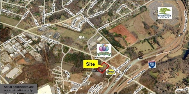
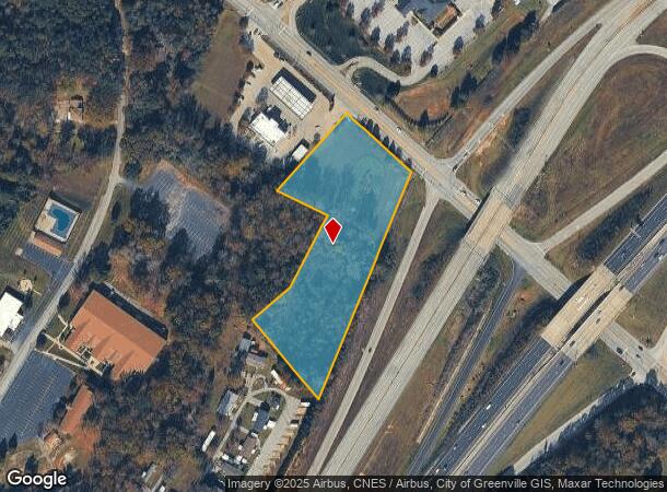
1605 Ne Main St, Simpsonville, SC 29681
NEARBY LISTINGS FOR SALE OR LEASE
Property Detail
1605 Ne Main St
Greenville-Anderson-Mauldin, SC
Property Of 385 417 Holdings Llc
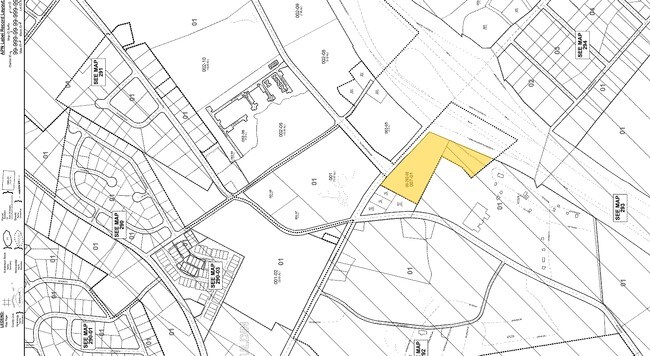
0292.00-01-007.01
MAP 0292.00; A
Commercialnec
Greenville
AE
South Carolina
45045C0418E
007.01
2025
4.14 AC
2024
Mauldin/Fountain
002903
Greenville/Spartanburg
884 SF
DEMOGRAPHICS near 1605 Ne Main St
1 Mile
3 Mile
5 Mile
2024 Total Population
3,549
52,212
134,053
2029 Population
3,889
57,510
148,128
Pop Growth 2024-2029
+ 9.58%
+ 10.15%
+ 10.50%
Average Age
42
40
40
2024 Total Households
1,535
21,060
52,807
HH Growth 2024-2029
+ 9.71%
+ 10.26%
+ 10.64%
Median Household Inc
$65,779
$82,965
$85,565
Avg Household Size
2.30
2.50
2.50
2024 Avg HH Vehicles
2.00
2.00
2.00
Median Home Value
$185,127
$238,931
$256,690
Median Year Built
1995
1995
1999
Nearby Places
Map Layers
Map Styles
 Street
 Aerial
- Restaurants
- Banks
- Shops
- Fitness
- Groceries
PUBLIC TRANSPORTATION
AIRPORT
Greenville Spartanburg International
DRIVE
WALK
Distance
Greenville Spartanburg International
30 min
21.6 mi
Freight Ports
North Charleston Terminal
DRIVE
WALK
Distance
North Charleston Terminal
224 min
200.2 mi
Nearby Properties
Address
Land Use
TOTAL SIZE
Lot Size
Zoning
Address
Land Use
TOTAL SIZE
Lot Size
Zoning
10.20 AC
R12
Address
Land Use
TOTAL SIZE
Lot Size
Zoning
10.35 AC
R12
Address
Land Use
TOTAL SIZE
Lot Size
Zoning
23.23 AC
Address
Land Use
TOTAL SIZE
Lot Size
Zoning
11.91 AC
RM20
Address
Land Use
TOTAL SIZE
Lot Size
Zoning
11.05 AC
S1
Address
Land Use
TOTAL SIZE
Lot Size
Zoning
6.27 AC
UVD
Address
Land Use
TOTAL SIZE
Lot Size
Zoning
12.31 AC
Address
Land Use
TOTAL SIZE
Lot Size
Zoning
17.59 AC
Address
Land Use
TOTAL SIZE
Lot Size
Zoning
29.21 AC
I1
Address
Land Use
TOTAL SIZE
Lot Size
Zoning
Address
Land Use
TOTAL SIZE
Lot Size
Zoning
5 AC
R12
Address
Land Use
TOTAL SIZE
Lot Size
Zoning
Address
Land Use
TOTAL SIZE
Lot Size
Zoning
10.78 AC
I1
Address
Land Use
TOTAL SIZE
Lot Size
Zoning
4.59 AC
BI
Address
Land Use
TOTAL SIZE
Lot Size
Zoning
24.12 AC
S1
Address
Land Use
TOTAL SIZE
Lot Size
Zoning
195.23 AC
RRROW
Address
Land Use
TOTAL SIZE
Lot Size
Zoning
9.46 AC
I1
Address
Land Use
TOTAL SIZE
Lot Size
Zoning
12.43 AC
RS
Address
Land Use
TOTAL SIZE
Lot Size
Zoning
5.30 AC
BI
Address
Land Use
TOTAL SIZE
Lot Size
Zoning
1,539 SF
11.20 AC
C2
Address
Land Use
TOTAL SIZE
Lot Size
Zoning
8.51 AC
S1
Address
Land Use
TOTAL SIZE
Lot Size
Zoning
50.13 AC
RM,S1
Address
Land Use
TOTAL SIZE
Lot Size
Zoning
12.31 AC
I1
Address
Land Use
TOTAL SIZE
Lot Size
Zoning
50.76 AC
PDC
Address
Land Use
TOTAL SIZE
Lot Size
Zoning
96.14 AC
NZ
Address
Land Use
TOTAL SIZE
Lot Size
Zoning
26.30 AC
ROI
Address
Land Use
TOTAL SIZE
Lot Size
Zoning
Address
Land Use
TOTAL SIZE
Lot Size
Zoning
51.30 AC
RS
Address
Land Use
TOTAL SIZE
Lot Size
Zoning
8.23 AC
S1
Address
Land Use
TOTAL SIZE
Lot Size
Zoning
6.50 AC
RM
The World's #1 Commercial Real Estate Marketplace
Connect with us
© 2025 CoStar Group
The information above has been obtained from sources believed reliable. While we do not doubt its accuracy we have not verified it and make no guarantee, warranty or representation about it. It is your responsibility to independently confirm its accuracy and completeness. Any projections, opinions, assumptions, or estimates used are for example only and do not represent the current or future performance of the property. The value of this transaction to you depends on tax and other factors which should be evaluated by your tax, financial, and legal advisors. You and your advisors should conduct a careful, independent investigation of the property to determine to your satisfaction the suitability of the property for your needs.