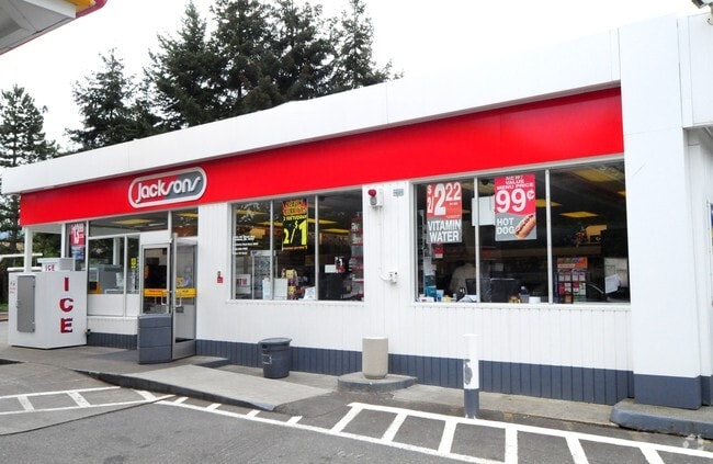
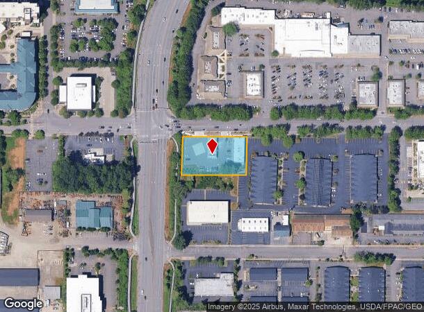
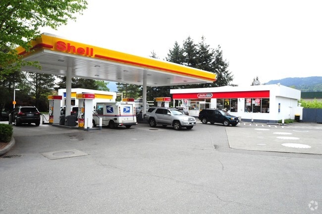
Property Record
1605 Nw Gilman Blvd, Issaquah, WA 98027

NEARBY LISTINGS FOR SALE OR LEASE
Property Detail
1605 Nw Gilman Blvd
202406-9077
BEG NXN SLY MGN OF FR 2 WITH ELY MGN OF SR 900 IN SE 1/4 OF SE 1/4 TH S 89-05-06 E 245.00 FT TH S 02-31-00 W 145.00 FT TH N 89-05-06 W 245.00 FT TH N 02-31-00 E ALG SD ELY MGN 145.00 FT TO BEG
Supermarket
King
AO
Washington
53033C0691J
202406
2025
0.82 AC
2024
Coal Creek/Issaquah
032103
Seattle/Puget Sound
3,976 SF
Seattle-Tacoma-Bellevue, WA
DEMOGRAPHICS near 1605 Nw Gilman Blvd
1 Mile
3 Mile
5 Mile
2024 Total Population
6,903
56,714
135,248
2029 Population
7,034
57,141
136,000
Pop Growth 2024-2029
+ 1.90%
+ 0.75%
+ 0.56%
Average Age
39
40
39
2024 Total Households
2,947
21,888
48,511
HH Growth 2024-2029
+ 1.49%
+ 0.60%
+ 0.44%
Median Household Inc
$137,602
$157,775
$172,655
Avg Household Size
2.30
2.50
2.70
2024 Avg HH Vehicles
2.00
2.00
2.00
Median Home Value
$963,169
$1,035,742
$1,027,188
Median Year Built
2005
1997
1993
Nearby Places
Map Layers
Map Styles
 Street
 Aerial
- Restaurants
- Banks
- Shops
- Fitness
- Groceries
PUBLIC TRANSPORTATION
AIRPORT
Seattle-Tacoma International
DRIVE
WALK
Distance
Seattle-Tacoma International
32 min
20.9 mi
Seattle Paine Field International
DRIVE
WALK
Distance
Seattle Paine Field International
45 min
32.0 mi
Nearby Properties
Address
Land Use
TOTAL SIZE
Lot Size
Zoning
Address
Land Use
TOTAL SIZE
Lot Size
Zoning
165,676 SF
21 AC
UC
Address
Land Use
TOTAL SIZE
Lot Size
Zoning
396,180 SF
7.91 AC
UV-MF
Address
Land Use
TOTAL SIZE
Lot Size
Zoning
378,896 SF
15.55 AC
VR
Address
Land Use
TOTAL SIZE
Lot Size
Zoning
408,400 SF
27.58 AC
R-20
Address
Land Use
TOTAL SIZE
Lot Size
Zoning
293,232 SF
13.31 AC
UV-L
Address
Land Use
TOTAL SIZE
Lot Size
Zoning
285,000 SF
46.89 AC
CF-F
Address
Land Use
TOTAL SIZE
Lot Size
Zoning
279,328 SF
2.62 AC
MU-CI
Address
Land Use
TOTAL SIZE
Lot Size
Zoning
286,224 SF
11.32 AC
UV-MF
Address
Land Use
TOTAL SIZE
Lot Size
Zoning
261,096 SF
8.74 AC
UV
Address
Land Use
TOTAL SIZE
Lot Size
Zoning
255,892 SF
10.28 AC
UV-MF
Address
Land Use
TOTAL SIZE
Lot Size
Zoning
249,508 SF
14.79 AC
R18
Address
Land Use
TOTAL SIZE
Lot Size
Zoning
230,527 SF
4.65 AC
UV-MF
Address
Land Use
TOTAL SIZE
Lot Size
Zoning
277,585 SF
15.51 AC
MU-CI
Address
Land Use
TOTAL SIZE
Lot Size
Zoning
229,670 SF
8.05 AC
MF-M
Address
Land Use
TOTAL SIZE
Lot Size
Zoning
117,506 SF
28.31 AC
UC
Address
Land Use
TOTAL SIZE
Lot Size
Zoning
135,945 SF
2.17 AC
UV-MF
Address
Land Use
TOTAL SIZE
Lot Size
Zoning
192,096 SF
8.11 AC
MF-M
Address
Land Use
TOTAL SIZE
Lot Size
Zoning
141,895 SF
4.01 AC
MU-CI
Address
Land Use
TOTAL SIZE
Lot Size
Zoning
145,000 SF
34.09 AC
R4
Address
Land Use
TOTAL SIZE
Lot Size
Zoning
136,565 SF
8.05 AC
CF-F
Address
Land Use
TOTAL SIZE
Lot Size
Zoning
124,120 SF
1.90 AC
UV-MUR
Address
Land Use
TOTAL SIZE
Lot Size
Zoning
42,340 SF
15.64 AC
UC
Address
Land Use
TOTAL SIZE
Lot Size
Zoning
184,116 SF
3.15 AC
MF-M
Address
Land Use
TOTAL SIZE
Lot Size
Zoning
531,355 SF
7.44 AC
UC
Address
Land Use
TOTAL SIZE
Lot Size
Zoning
3,910 SF
175.15 AC
CF-F
Address
Land Use
TOTAL SIZE
Lot Size
Zoning
16,407 SF
13.37 AC
MU-CI
Address
Land Use
TOTAL SIZE
Lot Size
Zoning
93,280 SF
1.22 AC
MUR
Address
Land Use
TOTAL SIZE
Lot Size
Zoning
118,552 SF
6.10 AC
VR
Address
Land Use
TOTAL SIZE
Lot Size
Zoning
111,818 SF
11.35 AC
CF-F
Address
Land Use
TOTAL SIZE
Lot Size
Zoning
133,960 SF
22.90 AC
MU
The World's #1 Commercial Real Estate Marketplace
Connect with us
© 2025 CoStar Group
The information above has been obtained from sources believed reliable. While we do not doubt its accuracy we have not verified it and make no guarantee, warranty or representation about it. It is your responsibility to independently confirm its accuracy and completeness. Any projections, opinions, assumptions, or estimates used are for example only and do not represent the current or future performance of the property. The value of this transaction to you depends on tax and other factors which should be evaluated by your tax, financial, and legal advisors. You and your advisors should conduct a careful, independent investigation of the property to determine to your satisfaction the suitability of the property for your needs.