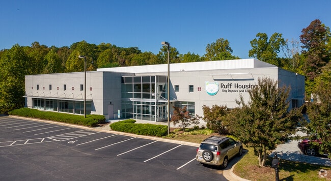
Property Record
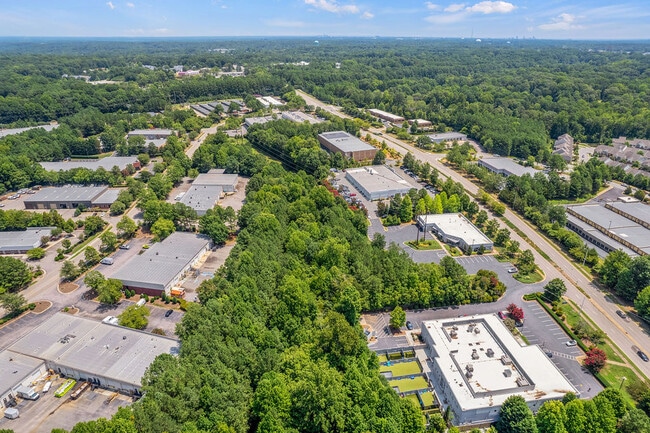
1605 Nw Maynard Rd, Cary, NC 27513


Property Detail
1605 Nw Maynard Rd
0754.15-73-4970-000
LO27 WEATHERFIELD INDUSTRIAL PK 96-1459
Commercialnec
Wake
I
North Carolina
AE The base floodplain where base flood elevations are provided. AE Zones are now used on new format FIRMs instead of A1-A30 Zones.
27
0
3.25 AC
2025
Cary
053523
Raleigh/Durham
19,094 SF
Raleigh-Cary, NC
NEARBY LISTINGS FOR SALE OR LEASE
DEMOGRAPHICS near 1605 Nw Maynard Rd
1 mile
3 mile
5 mile
2025 Total Population
10,015
96,403
206,349
2030 Population
10,722
103,365
222,318
Pop Growth 2025-2030
+ 7.06%
+ 7.22%
+ 7.74%
Average Age
40
40
39
2025 Total Households
4,142
39,495
82,526
HH Growth 2025-2030
+ 7.39%
+ 7.66%
+ 8.21%
Median Household Inc
$114,341
$118,941
$117,373
Avg Household Size
2.40
2.40
2.50
2025 Avg HH Vehicles
2.00
2.00
2.00
Median Home Value
$516,585
$532,701
$584,947
Median Year Built
1995
1994
1998
Nearby Places
Map Layers
Map Styles
 Street
 Aerial
Layers
 Traffic
 Biking
Places
Listings with unknown addresses are not visible on the map
- Restaurants
- Banks
- Shops
- Fitness
- Groceries
PUBLIC TRANSPORTATION
COMMUTER RAIL
Cary Station (Piedmont - North Carolina by Train (NC Train))
Drive
Walk
Distance
Cary Station (Piedmont - North Carolina by Train (NC Train))
5 min
2.4 mi
AIRPORT
Raleigh-Durham International
Drive
Walk
Distance
Raleigh-Durham International
17 min
8.1 mi
SALE & LEASE HISTORY
LISTING DATE
SALE/LEASE

Nov 30, 2022
For Sale
Nov 15, 2018
For Sale
Aug 08, 2024
For Sale
Nearby Properties
Address
Land Use
TOTAL SIZE
Lot Size
Zoning
Address
Land Use
TOTAL SIZE
Lot Size
Zoning
693,180 SF
17.61 AC
GCM
Address
Land Use
TOTAL SIZE
Lot Size
Zoning
517,812 SF
18.51 AC
RMFP
Address
Land Use
TOTAL SIZE
Lot Size
Zoning
439,439 SF
30.59 AC
OICU
Address
Land Use
TOTAL SIZE
Lot Size
Zoning
949,404 SF
26.71 AC
OIP
Address
Land Use
TOTAL SIZE
Lot Size
Zoning
534,604 SF
16.38 AC
RMFM
Address
Land Use
TOTAL SIZE
Lot Size
Zoning
433,914 SF
11.81 AC
MXD
Address
Land Use
TOTAL SIZE
Lot Size
Zoning
429,107 SF
13.67 AC
RMFP
Address
Land Use
TOTAL SIZE
Lot Size
Zoning
375,689 SF
32.73 AC
HDR
Address
Land Use
TOTAL SIZE
Lot Size
Zoning
312,475 SF
21.74 AC
RMFP
Address
Land Use
TOTAL SIZE
Lot Size
Zoning
453,970 SF
41.48 AC
RMF-C
Address
Land Use
TOTAL SIZE
Lot Size
Zoning
220,152 SF
67.76 AC
OIM
Address
Land Use
TOTAL SIZE
Lot Size
Zoning
300,662 SF
12.68 AC
BAC-G
Address
Land Use
TOTAL SIZE
Lot Size
Zoning
414,214 SF
11.23 AC
OIP
Address
Land Use
TOTAL SIZE
Lot Size
Zoning
444,236 SF
8.51 AC
ORDP
Address
Land Use
TOTAL SIZE
Lot Size
Zoning
269,702 SF
14.66 AC
GCM
Address
Land Use
TOTAL SIZE
Lot Size
Zoning
368,195 SF
32.11 AC
HDR
Address
Land Use
TOTAL SIZE
Lot Size
Zoning
408,968 SF
32.58 AC
HDR
Address
Land Use
TOTAL SIZE
Lot Size
Zoning
394,181 SF
28.62 AC
HDR
Address
Land Use
TOTAL SIZE
Lot Size
Zoning
513,738 SF
35.66 AC
OIP
Address
Land Use
TOTAL SIZE
Lot Size
Zoning
364,972 SF
35.18 AC
RMF-C
Address
Land Use
TOTAL SIZE
Lot Size
Zoning
242,305 SF
48.57 AC
R40
Address
Land Use
TOTAL SIZE
Lot Size
Zoning
226,107 SF
18.72 AC
RMFP
Address
Land Use
TOTAL SIZE
Lot Size
Zoning
194,462 SF
21.62 AC
OICU
Address
Land Use
TOTAL SIZE
Lot Size
Zoning
330,232 SF
18.45 AC
OIP
Address
Land Use
TOTAL SIZE
Lot Size
Zoning
294,088 SF
24.72 AC
RMF-C
Address
Land Use
TOTAL SIZE
Lot Size
Zoning
287,626 SF
14.61 AC
MUPD
Address
Land Use
TOTAL SIZE
Lot Size
Zoning
319,271 SF
38.96 AC
R12
Address
Land Use
TOTAL SIZE
Lot Size
Zoning
285,822 SF
24.57 AC
RMFP
Address
Land Use
TOTAL SIZE
Lot Size
Zoning
293,944 SF
8.89 AC
RMFP
Address
Land Use
TOTAL SIZE
Lot Size
Zoning
283,799 SF
32.70 AC
RMFP
The World's #1 Commercial Real Estate Marketplace
Connect with us
© 2026 CoStar Group
The information above has been obtained from sources believed reliable. While we do not doubt its accuracy we have not verified it and make no guarantee, warranty or representation about it. It is your responsibility to independently confirm its accuracy and completeness. Any projections, opinions, assumptions, or estimates used are for example only and do not represent the current or future performance of the property. The value of this transaction to you depends on tax and other factors which should be evaluated by your tax, financial, and legal advisors. You and your advisors should conduct a careful, independent investigation of the property to determine to your satisfaction the suitability of the property for your needs.