Property Record
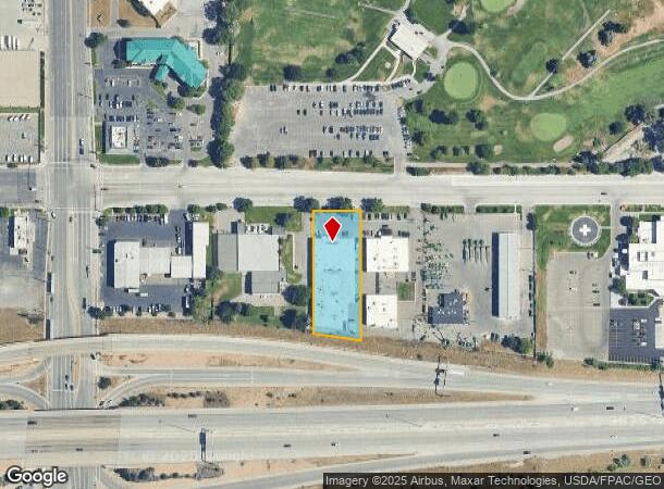
1605 W 2100 S, Salt Lake City, UT 84119

This Property Is For Sale
NEARBY LISTINGS FOR SALE OR LEASE
Property Detail
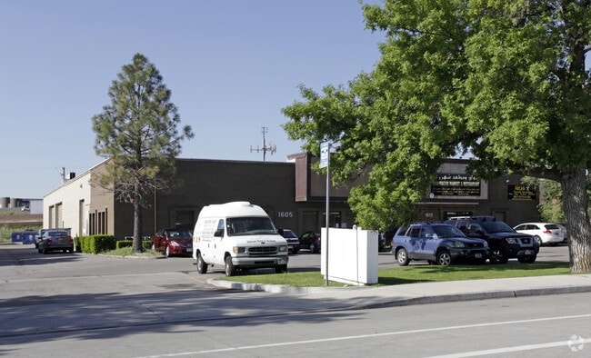
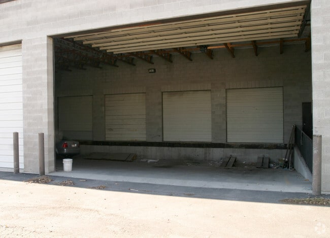
1605 W 2100 S
15-22-201-032-0000
BEG E 656.16 FT & S 44.76 FT FR N 1/4 COR SEC 22, T 1S, R 1WSLM; N 89^43 E 130 FT; S 0^0426 W 354.66 FT; N 81^44 W 131.34 FT; N 0^0426 E 335.228 FT TO BEG. 1.03 AC. 4094-0366 5264-0368 5540-1439 6137-2639 6637-0882 8427-0751 9080-0945 9224-1831 9443-
Warehouse
Salt Lake
X
Utah
49035C0281E
1.03 AC
2024
California Avenue
2025
Salt Lake City
102802
Salt Lake City, UT
28,735 SF
DEMOGRAPHICS near 1605 W 2100 S
1 Mile
3 Mile
5 Mile
2024 Total Population
6,011
92,033
344,117
2029 Population
6,000
92,818
349,313
Pop Growth 2024-2029
(0.18%)
+ 0.85%
+ 1.51%
Average Age
34
35
36
2024 Total Households
1,746
32,767
136,509
HH Growth 2024-2029
(0.23%)
+ 1.21%
+ 1.85%
Median Household Inc
$57,034
$53,071
$61,893
Avg Household Size
3.20
2.60
2.40
2024 Avg HH Vehicles
2.00
2.00
2.00
Median Home Value
$249,841
$313,421
$378,772
Median Year Built
1976
1980
1976
Nearby Places
- Restaurants
- Banks
- Shops
- Fitness
- Groceries
PUBLIC TRANSPORTATION
COMMUTER RAIL
North Temple Station (FrontRunner - Utah Transit Authority (UTA))
DRIVE
WALK
Distance
North Temple Station (FrontRunner - Utah Transit Authority (UTA))
11 min
5.8 mi
Warm Springs Relief Point (FrontRunner - Utah Transit Authority (UTA))
DRIVE
WALK
Distance
Warm Springs Relief Point (FrontRunner - Utah Transit Authority (UTA))
12 min
7.1 mi
AIRPORT
Salt Lake City International
DRIVE
WALK
Distance
Salt Lake City International
10 min
6.9 mi
Freight Ports
Port of Stockton
DRIVE
WALK
Distance
Port of Stockton
710 min
693.5 mi
Nearby Properties
Address
Land Use
TOTAL SIZE
Lot Size
Zoning
Address
Land Use
TOTAL SIZE
Lot Size
Zoning
1,330,058 SF
5.02 AC
D2
Address
Land Use
TOTAL SIZE
Lot Size
Zoning
488,509 SF
36.03 AC
FLEX
Address
Land Use
TOTAL SIZE
Lot Size
Zoning
163,932 SF
14.65 AC
PL
Address
Land Use
TOTAL SIZE
Lot Size
Zoning
828,269 SF
9.06 AC
RM
Address
Land Use
TOTAL SIZE
Lot Size
Zoning
208,868 SF
20.41 AC
I
Address
Land Use
TOTAL SIZE
Lot Size
Zoning
128,997 SF
3.04 AC
ESN
Address
Land Use
TOTAL SIZE
Lot Size
Zoning
673,062 SF
15.84 AC
RM
Address
Land Use
TOTAL SIZE
Lot Size
Zoning
185,436 SF
25.23 AC
RM
Address
Land Use
TOTAL SIZE
Lot Size
Zoning
502,104 SF
4.11 AC
E ST C
Address
Land Use
TOTAL SIZE
Lot Size
Zoning
95,854 SF
15.42 AC
CC
Address
Land Use
TOTAL SIZE
Lot Size
Zoning
322,076 SF
16.32 AC
PL
Address
Land Use
TOTAL SIZE
Lot Size
Zoning
195,790 SF
14.32 AC
RM
Address
Land Use
TOTAL SIZE
Lot Size
Zoning
76,096 SF
17.30 AC
RM
Address
Land Use
TOTAL SIZE
Lot Size
Zoning
84,870 SF
9.76 AC
MPMU
Address
Land Use
TOTAL SIZE
Lot Size
Zoning
347,330 SF
6.91 AC
CC
Address
Land Use
TOTAL SIZE
Lot Size
Zoning
217,700 SF
52.59 AC
FLEX
Address
Land Use
TOTAL SIZE
Lot Size
Zoning
171,839 SF
17.80 AC
CG
Address
Land Use
TOTAL SIZE
Lot Size
Zoning
401,887 SF
3.51 AC
RM
Address
Land Use
TOTAL SIZE
Lot Size
Zoning
80,985 SF
19.18 AC
RM
Address
Land Use
TOTAL SIZE
Lot Size
Zoning
29.13 AC
C-2
Address
Land Use
TOTAL SIZE
Lot Size
Zoning
426,280 SF
19.84 AC
M1
Address
Land Use
TOTAL SIZE
Lot Size
Zoning
116,268 SF
8.07 AC
RMF-45
Address
Land Use
TOTAL SIZE
Lot Size
Zoning
89,239 SF
14.78 AC
RM
Address
Land Use
TOTAL SIZE
Lot Size
Zoning
137,209 SF
38.90 AC
FLEX
Address
Land Use
TOTAL SIZE
Lot Size
Zoning
436,875 SF
26.95 AC
M-1
Address
Land Use
TOTAL SIZE
Lot Size
Zoning
381,105 SF
2.88 AC
CC
Address
Land Use
TOTAL SIZE
Lot Size
Zoning
750,887 SF
28 AC
M1
Address
Land Use
TOTAL SIZE
Lot Size
Zoning
213,286 SF
3.67 AC
CG
Address
Land Use
TOTAL SIZE
Lot Size
Zoning
177,906 SF
3.16 AC
RMF-75
Address
Land Use
TOTAL SIZE
Lot Size
Zoning
304,366 SF
2.71 AC
M
The World's #1 Commercial Real Estate Marketplace
Connect with us
© 2025 CoStar Group
The information above has been obtained from sources believed reliable. While we do not doubt its accuracy we have not verified it and make no guarantee, warranty or representation about it. It is your responsibility to independently confirm its accuracy and completeness. Any projections, opinions, assumptions, or estimates used are for example only and do not represent the current or future performance of the property. The value of this transaction to you depends on tax and other factors which should be evaluated by your tax, financial, and legal advisors. You and your advisors should conduct a careful, independent investigation of the property to determine to your satisfaction the suitability of the property for your needs.