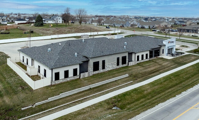
Property Record
1606 Nw Irvinedale Dr, Ankeny, IA 50023


Current Lease Availabilities
NEARBY LISTINGS FOR SALE OR LEASE
Property Detail
1606 Nw Irvinedale Dr
Des Moines-West Des Moines, IA
Hidden Creek Plat 4
181/00424-980-041
Polk
Daycare
Iowa
X
2.28 AC
19153C0185F
Ankeny
12,960 SF
Des Moines
DEMOGRAPHICS near 1606 Nw Irvinedale Dr
1 Mile
3 Mile
5 Mile
2024 Total Population
11,048
50,093
87,915
2029 Population
11,650
52,807
92,392
Pop Growth 2024-2029
+ 5.45%
+ 5.42%
+ 5.09%
Average Age
35
36
37
2024 Total Households
4,068
19,404
33,701
HH Growth 2024-2029
+ 5.70%
+ 5.63%
+ 5.26%
Median Household Inc
$98,773
$94,155
$96,633
Avg Household Size
2.70
2.50
2.60
2024 Avg HH Vehicles
2.00
2.00
2.00
Median Home Value
$289,138
$288,259
$291,831
Median Year Built
2008
2006
2005
Nearby Places
Map Layers
Map Styles
 Street
 Aerial
- Restaurants
- Banks
- Shops
- Fitness
- Groceries
PUBLIC TRANSPORTATION
AIRPORT
Des Moines International
DRIVE
WALK
Distance
Des Moines International
34 min
17.2 mi
Freight Ports
Port Milwaukee
DRIVE
WALK
Distance
Port Milwaukee
423 min
377.6 mi
Nearby Properties
Address
Land Use
TOTAL SIZE
Lot Size
Zoning
Address
Land Use
TOTAL SIZE
Lot Size
Zoning
2,732,552 SF
443.35 AC
Address
Land Use
TOTAL SIZE
Lot Size
Zoning
519,216 SF
42.20 AC
Address
Land Use
TOTAL SIZE
Lot Size
Zoning
272,072 SF
11.70 AC
Address
Land Use
TOTAL SIZE
Lot Size
Zoning
100,751 SF
12.67 AC
C-2
Address
Land Use
TOTAL SIZE
Lot Size
Zoning
143,249 SF
7.19 AC
Address
Land Use
TOTAL SIZE
Lot Size
Zoning
170,692 SF
6.54 AC
Address
Land Use
TOTAL SIZE
Lot Size
Zoning
96,344 SF
13.39 AC
PUD
Address
Land Use
TOTAL SIZE
Lot Size
Zoning
63,664 SF
9.02 AC
Address
Land Use
TOTAL SIZE
Lot Size
Zoning
175,424 SF
8.01 AC
Address
Land Use
TOTAL SIZE
Lot Size
Zoning
162,384 SF
11.16 AC
R-3
Address
Land Use
TOTAL SIZE
Lot Size
Zoning
144,992 SF
6.03 AC
Address
Land Use
TOTAL SIZE
Lot Size
Zoning
122,066 SF
5.27 AC
Address
Land Use
TOTAL SIZE
Lot Size
Zoning
150,733 SF
18.57 AC
M-1
Address
Land Use
TOTAL SIZE
Lot Size
Zoning
73,392 SF
6.70 AC
Address
Land Use
TOTAL SIZE
Lot Size
Zoning
51,108 SF
17.81 AC
Address
Land Use
TOTAL SIZE
Lot Size
Zoning
104,792 SF
8.25 AC
Address
Land Use
TOTAL SIZE
Lot Size
Zoning
98,020 SF
4.80 AC
Address
Land Use
TOTAL SIZE
Lot Size
Zoning
43,792 SF
12.50 AC
R1
Address
Land Use
TOTAL SIZE
Lot Size
Zoning
59,482 SF
5 AC
PUD
Address
Land Use
TOTAL SIZE
Lot Size
Zoning
67,486 SF
1.26 AC
PUD
Address
Land Use
TOTAL SIZE
Lot Size
Zoning
114,024 SF
10.82 AC
Address
Land Use
TOTAL SIZE
Lot Size
Zoning
97,868 SF
3.03 AC
Address
Land Use
TOTAL SIZE
Lot Size
Zoning
103,242 SF
2.62 AC
PUD
Address
Land Use
TOTAL SIZE
Lot Size
Zoning
106,176 SF
4.35 AC
Address
Land Use
TOTAL SIZE
Lot Size
Zoning
78,758 SF
8.15 AC
Address
Land Use
TOTAL SIZE
Lot Size
Zoning
57,306 SF
9.13 AC
R-2
Address
Land Use
TOTAL SIZE
Lot Size
Zoning
52,335 SF
1.04 AC
Address
Land Use
TOTAL SIZE
Lot Size
Zoning
82,405 SF
8.84 AC
R-2
Address
Land Use
TOTAL SIZE
Lot Size
Zoning
74,488 SF
2.34 AC
Address
Land Use
TOTAL SIZE
Lot Size
Zoning
53,800 SF
5.17 AC
The World's #1 Commercial Real Estate Marketplace
Connect with us
© 2026 CoStar Group
The information above has been obtained from sources believed reliable. While we do not doubt its accuracy we have not verified it and make no guarantee, warranty or representation about it. It is your responsibility to independently confirm its accuracy and completeness. Any projections, opinions, assumptions, or estimates used are for example only and do not represent the current or future performance of the property. The value of this transaction to you depends on tax and other factors which should be evaluated by your tax, financial, and legal advisors. You and your advisors should conduct a careful, independent investigation of the property to determine to your satisfaction the suitability of the property for your needs.