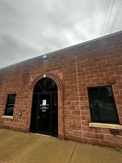
Property Record
1606 W 3Rd St, Red Wing, MN 55066
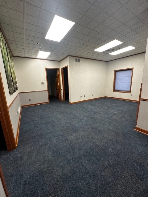
Current Lease Availabilities
Property Detail
1606 W 3Rd St
Red Wing, MN
SECT-30 TWP-113 RANGE-014 W EXT OF SWENEYS AD ID# 5-1980-02450 PT OF LOTS 8,9,&10 BLK 2 SEE BOOK G13 PAGE 378 PARCEL 3 EX PT
55.580.0280
GOODHUE
Officebuilding
Minnesota
2026
8-9
2025
0.54 AC
080201
Minnesota South Area
12,772 SF
Other Market Areas
NEARBY LISTINGS FOR SALE OR LEASE
DEMOGRAPHICS near 1606 W 3Rd St
1 mile
3 mile
5 mile
2025 Total Population
4,184
15,808
19,452
2030 Population
4,140
15,783
19,501
Pop Growth 2025-2030
(1.05%)
(0.16%)
+ 0.25%
Average Age
44
43
43
2025 Total Households
1,973
6,808
8,320
HH Growth 2025-2030
(1.06%)
(0.24%)
+ 0.16%
Median Household Inc
$57,692
$66,434
$69,042
Avg Household Size
2.00
2.20
2.30
2025 Avg HH Vehicles
1.00
2.00
2.00
Median Home Value
$250,404
$253,712
$257,722
Median Year Built
1959
1970
1971
Nearby Places
Map Layers
Map Styles
 Street
 Aerial
Layers
 Traffic
 Biking
Places
Listings with unknown addresses are not visible on the map
- Restaurants
- Banks
- Shops
- Fitness
- Groceries
PUBLIC TRANSPORTATION
COMMUTER RAIL
Red Wing Amtrak Station (Empire Builder - Amtrak)
Drive
Walk
Distance
Red Wing Amtrak Station (Empire Builder - Amtrak)
2 min
15 min
0.8 mi
Freight Ports
Port Milwaukee
Drive
Walk
Distance
Port Milwaukee
339 min
297.9 mi
Nearby Properties
Address
Land Use
TOTAL SIZE
Lot Size
Zoning
Address
Land Use
TOTAL SIZE
Lot Size
Zoning
194,165 SF
24.87 AC
Address
Land Use
TOTAL SIZE
Lot Size
Zoning
275,281 SF
126.31 AC
Address
Land Use
TOTAL SIZE
Lot Size
Zoning
70,746 SF
119.59 AC
Address
Land Use
TOTAL SIZE
Lot Size
Zoning
156,208 SF
3.99 AC
Address
Land Use
TOTAL SIZE
Lot Size
Zoning
68,000 SF
4.67 AC
Address
Land Use
TOTAL SIZE
Lot Size
Zoning
108,174 SF
41.88 AC
Address
Land Use
TOTAL SIZE
Lot Size
Zoning
136,318 SF
4.30 AC
Address
Land Use
TOTAL SIZE
Lot Size
Zoning
82,695 SF
13.84 AC
Address
Land Use
TOTAL SIZE
Lot Size
Zoning
102,996 SF
0.74 AC
Address
Land Use
TOTAL SIZE
Lot Size
Zoning
192,379 SF
22.63 AC
Address
Land Use
TOTAL SIZE
Lot Size
Zoning
173,191 SF
17.94 AC
Address
Land Use
TOTAL SIZE
Lot Size
Zoning
83,007 SF
0.76 AC
Address
Land Use
TOTAL SIZE
Lot Size
Zoning
102,896 SF
0.82 AC
Address
Land Use
TOTAL SIZE
Lot Size
Zoning
119,200 SF
3.45 AC
Address
Land Use
TOTAL SIZE
Lot Size
Zoning
111,223 SF
Address
Land Use
TOTAL SIZE
Lot Size
Zoning
193,336 SF
15.04 AC
Address
Land Use
TOTAL SIZE
Lot Size
Zoning
120,692 SF
21.92 AC
Address
Land Use
TOTAL SIZE
Lot Size
Zoning
172,140 SF
0.60 AC
Address
Land Use
TOTAL SIZE
Lot Size
Zoning
875,200 SF
1.95 AC
Address
Land Use
TOTAL SIZE
Lot Size
Zoning
53,808 SF
1.47 AC
Address
Land Use
TOTAL SIZE
Lot Size
Zoning
87,184 SF
4.96 AC
Address
Land Use
TOTAL SIZE
Lot Size
Zoning
205,520 SF
16.43 AC
Address
Land Use
TOTAL SIZE
Lot Size
Zoning
41,359 SF
2.99 AC
Address
Land Use
TOTAL SIZE
Lot Size
Zoning
14,268 SF
11.72 AC
Address
Land Use
TOTAL SIZE
Lot Size
Zoning
18,818 SF
7.91 AC
Address
Land Use
TOTAL SIZE
Lot Size
Zoning
223,377 SF
0.39 AC
Address
Land Use
TOTAL SIZE
Lot Size
Zoning
77,616 SF
100 AC
Address
Land Use
TOTAL SIZE
Lot Size
Zoning
51,799 SF
2.48 AC
The World's #1 Commercial Real Estate Marketplace
Connect with us
© 2026 CoStar Group
The information above has been obtained from sources believed reliable. While we do not doubt its accuracy we have not verified it and make no guarantee, warranty or representation about it. It is your responsibility to independently confirm its accuracy and completeness. Any projections, opinions, assumptions, or estimates used are for example only and do not represent the current or future performance of the property. The value of this transaction to you depends on tax and other factors which should be evaluated by your tax, financial, and legal advisors. You and your advisors should conduct a careful, independent investigation of the property to determine to your satisfaction the suitability of the property for your needs.