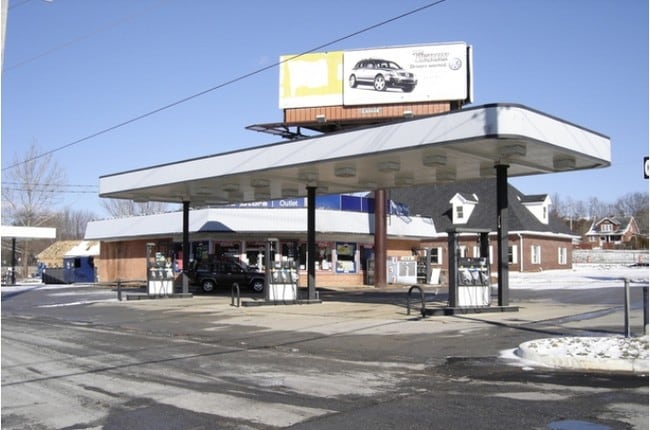
Property Record
1607 E Main St, Salem, VA 24153

Property Detail
1607 E Main St
77-2-8
LT 1-A 0.792 AC SEC 1 STOUTAMIRE SUBD
Commercialnec
Salem
HBD
Virginia
B and X Area of moderate flood hazard, usually the area between the limits of the 100-year and 500-year floods.
1
2025
0.79 AC
2025
Northwest Roanoke
010100
Roanoke
4,009 SF
Roanoke, VA
NEARBY LISTINGS FOR SALE OR LEASE
DEMOGRAPHICS near 1607 E Main St
1 mile
3 mile
5 mile
2025 Total Population
6,298
49,103
121,791
2030 Population
6,328
49,454
122,082
Pop Growth 2025-2030
+ 0.48%
+ 0.71%
+ 0.24%
Average Age
41
41
41
2025 Total Households
2,653
20,113
51,926
HH Growth 2025-2030
+ 0.57%
+ 0.75%
+ 0.19%
Median Household Inc
$57,572
$57,329
$61,614
Avg Household Size
2.30
2.30
2.20
2025 Avg HH Vehicles
2.00
2.00
2.00
Median Home Value
$215,312
$240,147
$255,425
Median Year Built
1964
1969
1965
Nearby Places
Map Layers
Map Styles
 Street
 Aerial
Transit
 Traffic
 Biking
Places
Listings with unknown addresses are not visible on the map
- Restaurants
- Banks
- Shops
- Fitness
- Groceries
PUBLIC TRANSPORTATION
AIRPORT
Roanoke/Blacksburg Regional (Woodrum Field)
Drive
Walk
Distance
Roanoke/Blacksburg Regional (Woodrum Field)
14 min
5.6 mi
Freight Ports
Virginia Port Authority - Richmond
Drive
Walk
Distance
Virginia Port Authority - Richmond
1 min
143.4 mi
Nearby Properties
Address
Land Use
TOTAL SIZE
Lot Size
Zoning
Address
Land Use
TOTAL SIZE
Lot Size
Zoning
160 AC
RSF
Address
Land Use
TOTAL SIZE
Lot Size
Zoning
3,850 SF
60.20 AC
INPUD
Address
Land Use
TOTAL SIZE
Lot Size
Zoning
81,148 SF
52.04 AC
CUDRSF
Address
Land Use
TOTAL SIZE
Lot Size
Zoning
288,464 SF
40.14 AC
RSF
Address
Land Use
TOTAL SIZE
Lot Size
Zoning
39,455 SF
12.01 AC
CLS
Address
Land Use
TOTAL SIZE
Lot Size
Zoning
421,634 SF
15.99 AC
HBD
Address
Land Use
TOTAL SIZE
Lot Size
Zoning
177,095 SF
18.55 AC
RMF
Address
Land Use
TOTAL SIZE
Lot Size
Zoning
69,831 SF
73.54 AC
HBD
Address
Land Use
TOTAL SIZE
Lot Size
Zoning
49,887 SF
2.28 AC
C1
Address
Land Use
TOTAL SIZE
Lot Size
Zoning
20,646 SF
23.33 AC
R2
Address
Land Use
TOTAL SIZE
Lot Size
Zoning
155,000 SF
3.78 AC
CUD
Address
Land Use
TOTAL SIZE
Lot Size
Zoning
83,167 SF
9.75 AC
C1
Address
Land Use
TOTAL SIZE
Lot Size
Zoning
181,455 SF
6.24 AC
RMF
Address
Land Use
TOTAL SIZE
Lot Size
Zoning
134,471 SF
16.39 AC
RMF
Address
Land Use
TOTAL SIZE
Lot Size
Zoning
76,280 SF
9.51 AC
CUD
Address
Land Use
TOTAL SIZE
Lot Size
Zoning
138,887 SF
13.03 AC
HBD
Address
Land Use
TOTAL SIZE
Lot Size
Zoning
120,584 SF
9.41 AC
HM
Address
Land Use
TOTAL SIZE
Lot Size
Zoning
331,365 SF
61.27 AC
I-2
Address
Land Use
TOTAL SIZE
Lot Size
Zoning
565,151 SF
56.04 AC
HM
Address
Land Use
TOTAL SIZE
Lot Size
Zoning
122,462 SF
40.92 AC
INPUD
Address
Land Use
TOTAL SIZE
Lot Size
Zoning
28,221 SF
20.18 AC
RMF
Address
Land Use
TOTAL SIZE
Lot Size
Zoning
123,651 SF
29.38 AC
R2S
Address
Land Use
TOTAL SIZE
Lot Size
Zoning
71,238 SF
3.62 AC
CLS
Address
Land Use
TOTAL SIZE
Lot Size
Zoning
5,310 SF
21.40 AC
RMF
Address
Land Use
TOTAL SIZE
Lot Size
Zoning
65,428 SF
34.05 AC
C1
Address
Land Use
TOTAL SIZE
Lot Size
Zoning
7,590 SF
14.18 AC
RMF
Address
Land Use
TOTAL SIZE
Lot Size
Zoning
442,530 SF
40.32 AC
HM
Address
Land Use
TOTAL SIZE
Lot Size
Zoning
12,159 SF
8.77 AC
RMF
Address
Land Use
TOTAL SIZE
Lot Size
Zoning
47,451 SF
1.58 AC
RB
Address
Land Use
TOTAL SIZE
Lot Size
Zoning
32,286 SF
3.62 AC
RMF
The World's #1 Commercial Real Estate Marketplace
Connect with us
© 2026 CoStar Group
The information above has been obtained from sources believed reliable. While we do not doubt its accuracy we have not verified it and make no guarantee, warranty or representation about it. It is your responsibility to independently confirm its accuracy and completeness. Any projections, opinions, assumptions, or estimates used are for example only and do not represent the current or future performance of the property. The value of this transaction to you depends on tax and other factors which should be evaluated by your tax, financial, and legal advisors. You and your advisors should conduct a careful, independent investigation of the property to determine to your satisfaction the suitability of the property for your needs.