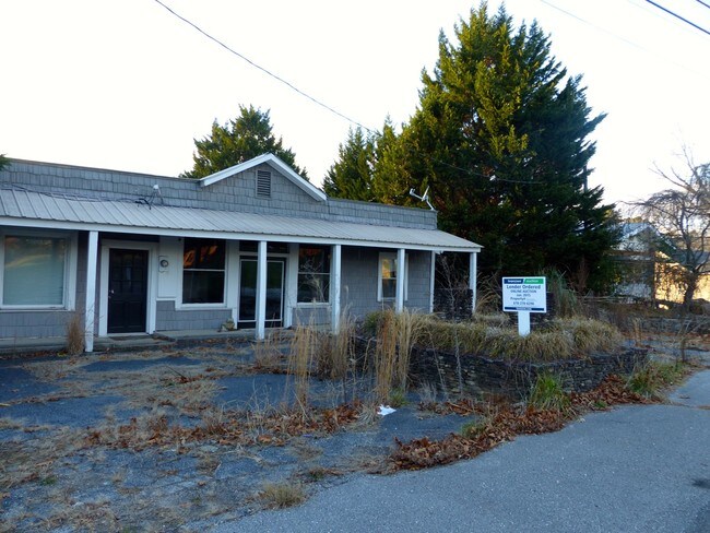
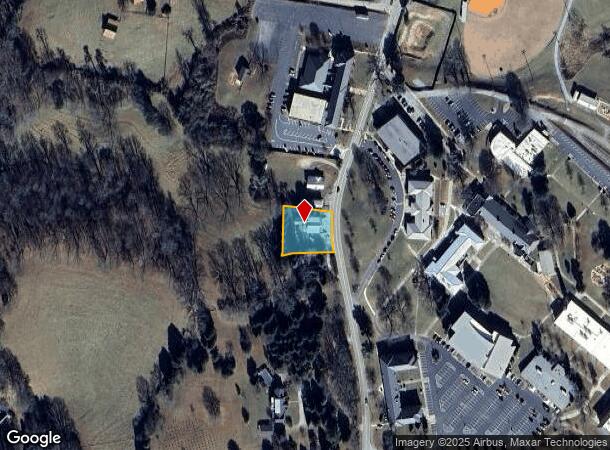
Property Record
1607 Highway 197 N, Clarkesville, GA 30523

NEARBY LISTINGS FOR SALE OR LEASE
Property Detail
1607 Highway 197 N
065-081
Michael Strom & Susan Strom
Commercialnec
11-83 PB 22-46 DB 1191-236
X
Habersham
13137C0120D
Georgia
0
0.51 AC
2025
Georgia Northeast
000203
Other Market Areas
4,940 SF
Cornelia, GA
DEMOGRAPHICS near 1607 Highway 197 N
1 Mile
3 Mile
5 Mile
2024 Total Population
772
6,079
12,926
2029 Population
829
6,595
14,084
Pop Growth 2024-2029
+ 7.38%
+ 8.49%
+ 8.96%
Average Age
43
43
43
2024 Total Households
284
2,411
4,991
HH Growth 2024-2029
+ 7.39%
+ 8.21%
+ 8.64%
Median Household Inc
$64,815
$65,935
$64,070
Avg Household Size
2.50
2.40
2.50
2024 Avg HH Vehicles
2.00
2.00
2.00
Median Home Value
$245,122
$237,387
$234,208
Median Year Built
1996
1991
1992
Nearby Places
Map Layers
Map Styles
 Street
 Aerial
- Restaurants
- Banks
- Shops
- Fitness
- Groceries
Nearby Properties
Address
Land Use
TOTAL SIZE
Lot Size
Zoning
Address
Land Use
TOTAL SIZE
Lot Size
Zoning
238,071 SF
303.19 AC
HI
Address
Land Use
TOTAL SIZE
Lot Size
Zoning
78,537 SF
41.34 AC
LI
Address
Land Use
TOTAL SIZE
Lot Size
Zoning
105,213 SF
8.49 AC
HI
Address
Land Use
TOTAL SIZE
Lot Size
Zoning
247,562 SF
26.58 AC
I
Address
Land Use
TOTAL SIZE
Lot Size
Zoning
66,865 SF
7.06 AC
R2
Address
Land Use
TOTAL SIZE
Lot Size
Zoning
17,955 SF
12 AC
INS
Address
Land Use
TOTAL SIZE
Lot Size
Zoning
70,563 SF
9.66 AC
R1A
Address
Land Use
TOTAL SIZE
Lot Size
Zoning
8,725 SF
7.44 AC
LI
Address
Land Use
TOTAL SIZE
Lot Size
Zoning
183,619 SF
15.20 AC
MI
Address
Land Use
TOTAL SIZE
Lot Size
Zoning
44,885 SF
33.44 AC
LI
Address
Land Use
TOTAL SIZE
Lot Size
Zoning
72,402 SF
8.45 AC
HI
Address
Land Use
TOTAL SIZE
Lot Size
Zoning
50,890 SF
0.80 AC
CB
Address
Land Use
TOTAL SIZE
Lot Size
Zoning
34,422 SF
1.50 AC
CB
Address
Land Use
TOTAL SIZE
Lot Size
Zoning
40,450 SF
2.20 AC
INS
Address
Land Use
TOTAL SIZE
Lot Size
Zoning
10,256 SF
1.35 AC
HB
Address
Land Use
TOTAL SIZE
Lot Size
Zoning
77,778 SF
18 AC
MI
Address
Land Use
TOTAL SIZE
Lot Size
Zoning
13,560 SF
0.36 AC
PRO
Address
Land Use
TOTAL SIZE
Lot Size
Zoning
27,200 SF
3 AC
HI
Address
Land Use
TOTAL SIZE
Lot Size
Zoning
18,958 SF
16.49 AC
I
Address
Land Use
TOTAL SIZE
Lot Size
Zoning
62,550 SF
6.52 AC
PRO
Address
Land Use
TOTAL SIZE
Lot Size
Zoning
16,920 SF
0.98 AC
CB
Address
Land Use
TOTAL SIZE
Lot Size
Zoning
48,405 SF
2.30 AC
INS
Address
Land Use
TOTAL SIZE
Lot Size
Zoning
952 SF
2.22 AC
R2
Address
Land Use
TOTAL SIZE
Lot Size
Zoning
6,901 SF
2.56 AC
HB
Address
Land Use
TOTAL SIZE
Lot Size
Zoning
14,050 SF
1.96 AC
HB
Address
Land Use
TOTAL SIZE
Lot Size
Zoning
59,291 SF
9.54 AC
HI
Address
Land Use
TOTAL SIZE
Lot Size
Zoning
18,408 SF
5.79 AC
LI
Address
Land Use
TOTAL SIZE
Lot Size
Zoning
212.59 AC
LI
Address
Land Use
TOTAL SIZE
Lot Size
Zoning
204.24 AC
AGRI
Address
Land Use
TOTAL SIZE
Lot Size
Zoning
327.35 AC
AGRI
The World's #1 Commercial Real Estate Marketplace
Connect with us
© 2025 CoStar Group
The information above has been obtained from sources believed reliable. While we do not doubt its accuracy we have not verified it and make no guarantee, warranty or representation about it. It is your responsibility to independently confirm its accuracy and completeness. Any projections, opinions, assumptions, or estimates used are for example only and do not represent the current or future performance of the property. The value of this transaction to you depends on tax and other factors which should be evaluated by your tax, financial, and legal advisors. You and your advisors should conduct a careful, independent investigation of the property to determine to your satisfaction the suitability of the property for your needs.