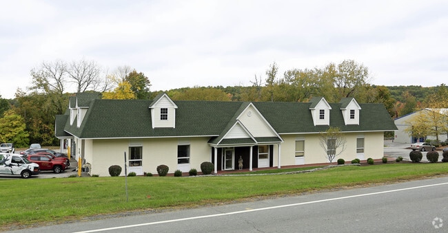
Property Record
1607 Route 300, Newburgh, NY 12550
NEARBY LISTINGS FOR SALE OR LEASE
Property Detail
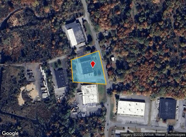
1607 Route 300
334600-034-000-0001-028.000-0000
Orange
Commercialnec
New York
X
28.00
36111C0900F
1.80 AC
2024
Newburgh
2024
Northern New Jersey
010300
New York-Jersey City-White Plains, NY-NJ
DEMOGRAPHICS near 1607 Route 300
1 Mile
3 Mile
5 Mile
2024 Total Population
2,358
27,181
78,557
2029 Population
2,427
27,759
79,805
Pop Growth 2024-2029
+ 2.93%
+ 2.13%
+ 1.59%
Average Age
41
41
39
2024 Total Households
827
9,828
28,491
HH Growth 2024-2029
+ 2.78%
+ 2.20%
+ 1.68%
Median Household Inc
$96,153
$99,605
$82,316
Avg Household Size
2.70
2.70
2.60
2024 Avg HH Vehicles
2.00
2.00
2.00
Median Home Value
$265,460
$292,779
$289,979
Median Year Built
1964
1973
1966
Nearby Places
Map Layers
Map Styles
 Street
 Aerial
- Restaurants
- Banks
- Shops
- Fitness
- Groceries
PUBLIC TRANSPORTATION
COMMUTER RAIL
Beacon Station (Hudson Line - Metro-North Commuter Railroad Company (Metro-North))
DRIVE
WALK
Distance
Beacon Station (Hudson Line - Metro-North Commuter Railroad Company (Metro-North))
15 min
7.5 mi
AIRPORT
New York Stewart International
DRIVE
WALK
Distance
New York Stewart International
15 min
7.0 mi
SALE & LEASE HISTORY
LISTING DATE
SALE/LEASE

Oct 25, 2016
For Lease
Nov 03, 2023
For Lease
May 14, 2025
For Lease
Mar 15, 2017
For Lease
Dec 12, 2024
For Lease
Apr 24, 2018
For Lease
Apr 22, 2020
For Lease
Nearby Properties
Address
Land Use
TOTAL SIZE
Lot Size
Zoning
Address
Land Use
TOTAL SIZE
Lot Size
Zoning
927,041 SF
104.37 AC
Address
Land Use
TOTAL SIZE
Lot Size
Zoning
130,037 SF
128.80 AC
Address
Land Use
TOTAL SIZE
Lot Size
Zoning
71.72 AC
Address
Land Use
TOTAL SIZE
Lot Size
Zoning
44.50 AC
Address
Land Use
TOTAL SIZE
Lot Size
Zoning
505,577 SF
50.50 AC
Address
Land Use
TOTAL SIZE
Lot Size
Zoning
265,660 SF
24.20 AC
Address
Land Use
TOTAL SIZE
Lot Size
Zoning
29,935 SF
31.60 AC
04
Address
Land Use
TOTAL SIZE
Lot Size
Zoning
67,448 SF
6.30 AC
RL
Address
Land Use
TOTAL SIZE
Lot Size
Zoning
71,379 SF
20.80 AC
Address
Land Use
TOTAL SIZE
Lot Size
Zoning
200,000 SF
13.80 AC
CD
Address
Land Use
TOTAL SIZE
Lot Size
Zoning
97,011 SF
19.70 AC
Address
Land Use
TOTAL SIZE
Lot Size
Zoning
115,361 SF
17.70 AC
IND
Address
Land Use
TOTAL SIZE
Lot Size
Zoning
73,585 SF
5.60 AC
04
Address
Land Use
TOTAL SIZE
Lot Size
Zoning
10.30 AC
Address
Land Use
TOTAL SIZE
Lot Size
Zoning
30,801 SF
2.40 AC
IND
Address
Land Use
TOTAL SIZE
Lot Size
Zoning
69,748 SF
13.85 AC
RH
Address
Land Use
TOTAL SIZE
Lot Size
Zoning
215,219 SF
14.57 AC
Address
Land Use
TOTAL SIZE
Lot Size
Zoning
Address
Land Use
TOTAL SIZE
Lot Size
Zoning
22,088 SF
5.02 AC
IND
Address
Land Use
TOTAL SIZE
Lot Size
Zoning
49.60 AC
IND
Address
Land Use
TOTAL SIZE
Lot Size
Zoning
921,380 SF
9.90 AC
Address
Land Use
TOTAL SIZE
Lot Size
Zoning
Address
Land Use
TOTAL SIZE
Lot Size
Zoning
137,765 SF
14 AC
Address
Land Use
TOTAL SIZE
Lot Size
Zoning
62,458 SF
7.20 AC
Address
Land Use
TOTAL SIZE
Lot Size
Zoning
99,030 SF
5.90 AC
Address
Land Use
TOTAL SIZE
Lot Size
Zoning
55,859 SF
15.30 AC
Address
Land Use
TOTAL SIZE
Lot Size
Zoning
125,946 SF
13.20 AC
Address
Land Use
TOTAL SIZE
Lot Size
Zoning
173,319 SF
28.30 AC
04
Address
Land Use
TOTAL SIZE
Lot Size
Zoning
75,620 SF
12.80 AC
Address
Land Use
TOTAL SIZE
Lot Size
Zoning
61,822 SF
7.30 AC
The World's #1 Commercial Real Estate Marketplace
Connect with us
© 2025 CoStar Group
The information above has been obtained from sources believed reliable. While we do not doubt its accuracy we have not verified it and make no guarantee, warranty or representation about it. It is your responsibility to independently confirm its accuracy and completeness. Any projections, opinions, assumptions, or estimates used are for example only and do not represent the current or future performance of the property. The value of this transaction to you depends on tax and other factors which should be evaluated by your tax, financial, and legal advisors. You and your advisors should conduct a careful, independent investigation of the property to determine to your satisfaction the suitability of the property for your needs.