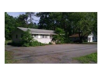
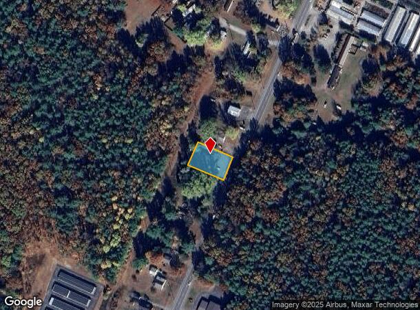
Property Record
1607 Route 9, Fort Edward, NY 12828
NEARBY LISTINGS FOR SALE OR LEASE
Property Detail
1607 Route 9
Albany-Schenectady-Troy, NY
Saratoga
414489-063-002-0001-003-000-0000
New York
Commercialofficeresidentialmixeduse
3.000
2025
0.35 AC
2024
Saratoga County
060102
Albany/Schenectady/Troy
2,184 SF
DEMOGRAPHICS near 1607 Route 9
1 Mile
3 Mile
5 Mile
2024 Total Population
2,876
21,037
58,197
2029 Population
2,983
21,398
58,086
Pop Growth 2024-2029
+ 3.72%
+ 1.72%
(0.19%)
Average Age
43
42
42
2024 Total Households
1,156
8,965
24,903
HH Growth 2024-2029
+ 3.72%
+ 1.60%
(0.29%)
Median Household Inc
$99,471
$77,614
$69,679
Avg Household Size
2.40
2.30
2.30
2024 Avg HH Vehicles
2.00
2.00
2.00
Median Home Value
$235,265
$201,793
$191,354
Median Year Built
1983
1973
1967
Nearby Places
- Restaurants
- Banks
- Shops
- Fitness
- Groceries
PUBLIC TRANSPORTATION
COMMUTER RAIL
Fort Edward Amtrak (Adirondack - Amtrak, Ethan Allen Express - Amtrak)
DRIVE
WALK
Distance
Fort Edward Amtrak (Adirondack - Amtrak, Ethan Allen Express - Amtrak)
10 min
5.6 mi
Freight Ports
Albany, NY Port
DRIVE
WALK
Distance
Albany, NY Port
67 min
51.0 mi
Nearby Properties
Address
Land Use
TOTAL SIZE
Lot Size
Zoning
Address
Land Use
TOTAL SIZE
Lot Size
Zoning
273,242 SF
11.07 AC
GC2
Address
Land Use
TOTAL SIZE
Lot Size
Zoning
115.90 AC
WR
Address
Land Use
TOTAL SIZE
Lot Size
Zoning
35.53 AC
HI
Address
Land Use
TOTAL SIZE
Lot Size
Zoning
161,338 SF
1.74 AC
GC2
Address
Land Use
TOTAL SIZE
Lot Size
Zoning
9,216 SF
32.20 AC
UR
Address
Land Use
TOTAL SIZE
Lot Size
Zoning
938 SF
80.03 AC
C1
Address
Land Use
TOTAL SIZE
Lot Size
Zoning
5,680 SF
39.79 AC
UR
Address
Land Use
TOTAL SIZE
Lot Size
Zoning
1.91 AC
HI
Address
Land Use
TOTAL SIZE
Lot Size
Zoning
183,950 SF
11.41 AC
C1
Address
Land Use
TOTAL SIZE
Lot Size
Zoning
144,029 SF
28.34 AC
R1
Address
Land Use
TOTAL SIZE
Lot Size
Zoning
91,000 SF
0.52 AC
GC2
Address
Land Use
TOTAL SIZE
Lot Size
Zoning
70,176 SF
3.50 AC
GC1
Address
Land Use
TOTAL SIZE
Lot Size
Zoning
22,317 SF
5.28 AC
C1
Address
Land Use
TOTAL SIZE
Lot Size
Zoning
16.20 AC
R1
Address
Land Use
TOTAL SIZE
Lot Size
Zoning
8,683 SF
8.27 AC
HI
Address
Land Use
TOTAL SIZE
Lot Size
Zoning
125,082 SF
17.54 AC
R2
Address
Land Use
TOTAL SIZE
Lot Size
Zoning
176,655 SF
1.91 AC
GC2
Address
Land Use
TOTAL SIZE
Lot Size
Zoning
76,451 SF
23.20 AC
R2
Address
Land Use
TOTAL SIZE
Lot Size
Zoning
64,654 SF
4.03 AC
GC1
Address
Land Use
TOTAL SIZE
Lot Size
Zoning
4,340 SF
0.40 AC
PUD
Address
Land Use
TOTAL SIZE
Lot Size
Zoning
55,069 SF
6.76 AC
CI-18
Address
Land Use
TOTAL SIZE
Lot Size
Zoning
1,216 SF
34.17 AC
R2
Address
Land Use
TOTAL SIZE
Lot Size
Zoning
11,068 SF
6.90 AC
CLI
Address
Land Use
TOTAL SIZE
Lot Size
Zoning
54,736 SF
1.58 AC
R-M
Address
Land Use
TOTAL SIZE
Lot Size
Zoning
1,400 SF
31.07 AC
R3
Address
Land Use
TOTAL SIZE
Lot Size
Zoning
56,884 SF
8.73 AC
R2
Address
Land Use
TOTAL SIZE
Lot Size
Zoning
48,840 SF
9.34 AC
R-M
Address
Land Use
TOTAL SIZE
Lot Size
Zoning
129,675 SF
11.69 AC
CLI
Address
Land Use
TOTAL SIZE
Lot Size
Zoning
62,278 SF
6.86 AC
C1
Address
Land Use
TOTAL SIZE
Lot Size
Zoning
36,657 SF
5.12 AC
C2
The World's #1 Commercial Real Estate Marketplace
Connect with us
© 2025 CoStar Group
The information above has been obtained from sources believed reliable. While we do not doubt its accuracy we have not verified it and make no guarantee, warranty or representation about it. It is your responsibility to independently confirm its accuracy and completeness. Any projections, opinions, assumptions, or estimates used are for example only and do not represent the current or future performance of the property. The value of this transaction to you depends on tax and other factors which should be evaluated by your tax, financial, and legal advisors. You and your advisors should conduct a careful, independent investigation of the property to determine to your satisfaction the suitability of the property for your needs.