Property Record
1608 Porter Rd, Union, NJ 07083
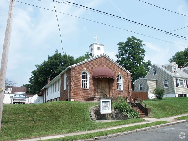

This Property Is For Sale
Property Detail
1608 Porter Rd
Newark, NJ
FACILITY NAME: CHURCH
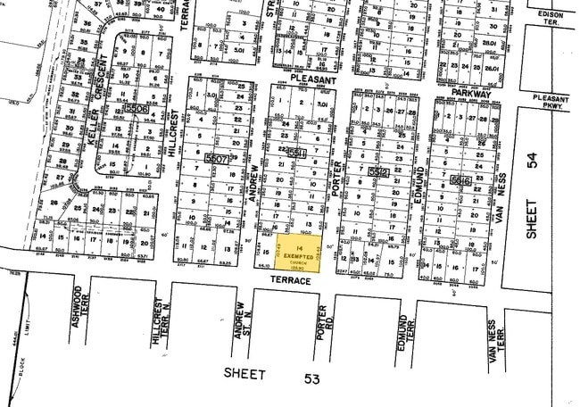
19-05511-0000-00014
Union
Religious
New Jersey
B and X Area of moderate flood hazard, usually the area between the limits of the 100-year and 500-year floods.
14
0
0.26 AC
2025
Route 22 East
032702
Northern New Jersey
NEARBY LISTINGS FOR SALE OR LEASE
DEMOGRAPHICS near 1608 Porter Rd
1 mile
3 mile
5 mile
2025 Total Population
34,871
267,024
715,178
2030 Population
36,212
277,127
744,510
Pop Growth 2025-2030
+ 3.85%
+ 3.78%
+ 4.10%
Average Age
40
39
39
2025 Total Households
12,100
93,864
256,392
HH Growth 2025-2030
+ 3.90%
+ 3.92%
+ 4.32%
Median Household Inc
$107,601
$92,144
$77,859
Avg Household Size
2.80
2.70
2.70
2025 Avg HH Vehicles
2.00
2.00
1.00
Median Home Value
$452,861
$456,368
$473,292
Median Year Built
1953
1952
1957
Nearby Places
Map Layers
Map Styles
 Street
 Aerial
Transit
 Traffic
 Biking
Places
Listings with unknown addresses are not visible on the map
- Restaurants
- Banks
- Shops
- Fitness
- Groceries
PUBLIC TRANSPORTATION
COMMUTER RAIL
Maplewood (Morris & Essex Gladstone Branch - NJ Transit Commuter Rail (NJ Transit), Morris & Essex Morristown Line - NJ Transit Commuter Rail (NJ Transit))
Drive
Walk
Distance
Maplewood (Morris & Essex Gladstone Branch - NJ Transit Commuter Rail (NJ Transit), Morris & Essex Morristown Line - NJ Transit Commuter Rail (NJ Transit))
8 min
2.0 mi
Union (Raritan Valley Line - NJ Transit Commuter Rail (NJ Transit))
Drive
Walk
Distance
Union (Raritan Valley Line - NJ Transit Commuter Rail (NJ Transit))
8 min
2.8 mi
AIRPORT
Newark Liberty International
Drive
Walk
Distance
Newark Liberty International
14 min
9.4 mi
LaGuardia
Drive
Walk
Distance
LaGuardia
51 min
28.8 mi
John F Kennedy International
Drive
Walk
Distance
John F Kennedy International
61 min
36.8 mi
Freight Ports
Maher Terminal
Drive
Walk
Distance
Maher Terminal
17 min
9.0 mi
Nearby Properties
Address
Land Use
TOTAL SIZE
Lot Size
Zoning
Address
Land Use
TOTAL SIZE
Lot Size
Zoning
57.23 AC
U
Address
Land Use
TOTAL SIZE
Lot Size
Zoning
0.61 AC
Address
Land Use
TOTAL SIZE
Lot Size
Zoning
231 AC
R1-7
Address
Land Use
TOTAL SIZE
Lot Size
Zoning
219 AC
R1-7
Address
Land Use
TOTAL SIZE
Lot Size
Zoning
1,136 SF
6.51 AC
Address
Land Use
TOTAL SIZE
Lot Size
Zoning
32.27 AC
CCRC
Address
Land Use
TOTAL SIZE
Lot Size
Zoning
107.41 AC
Address
Land Use
TOTAL SIZE
Lot Size
Zoning
Address
Land Use
TOTAL SIZE
Lot Size
Zoning
0.23 AC
REDV
Address
Land Use
TOTAL SIZE
Lot Size
Zoning
4.60 AC
PRD
Address
Land Use
TOTAL SIZE
Lot Size
Zoning
13.80 AC
R1-5
Address
Land Use
TOTAL SIZE
Lot Size
Zoning
310.45 AC
Address
Land Use
TOTAL SIZE
Lot Size
Zoning
1 SF
117.50 AC
Address
Land Use
TOTAL SIZE
Lot Size
Zoning
Address
Land Use
TOTAL SIZE
Lot Size
Zoning
Address
Land Use
TOTAL SIZE
Lot Size
Zoning
117,703 SF
8.29 AC
Address
Land Use
TOTAL SIZE
Lot Size
Zoning
19,498 SF
0.67 AC
FVRZ
Address
Land Use
TOTAL SIZE
Lot Size
Zoning
295,160 SF
3.72 AC
Address
Land Use
TOTAL SIZE
Lot Size
Zoning
6.05 AC
RO
Address
Land Use
TOTAL SIZE
Lot Size
Zoning
3.64 AC
Address
Land Use
TOTAL SIZE
Lot Size
Zoning
Address
Land Use
TOTAL SIZE
Lot Size
Zoning
5.65 AC
R100
Address
Land Use
TOTAL SIZE
Lot Size
Zoning
4.08 AC
Address
Land Use
TOTAL SIZE
Lot Size
Zoning
103,773 SF
35.47 AC
Address
Land Use
TOTAL SIZE
Lot Size
Zoning
16.10 AC
R1-5
Address
Land Use
TOTAL SIZE
Lot Size
Zoning
4 AC
R1-5
Address
Land Use
TOTAL SIZE
Lot Size
Zoning
1.25 AC
CBR1
Address
Land Use
TOTAL SIZE
Lot Size
Zoning
3.98 AC
Address
Land Use
TOTAL SIZE
Lot Size
Zoning
1.23 AC
R75
Address
Land Use
TOTAL SIZE
Lot Size
Zoning
The World's #1 Commercial Real Estate Marketplace
Connect with us
© 2026 CoStar Group
The information above has been obtained from sources believed reliable. While we do not doubt its accuracy we have not verified it and make no guarantee, warranty or representation about it. It is your responsibility to independently confirm its accuracy and completeness. Any projections, opinions, assumptions, or estimates used are for example only and do not represent the current or future performance of the property. The value of this transaction to you depends on tax and other factors which should be evaluated by your tax, financial, and legal advisors. You and your advisors should conduct a careful, independent investigation of the property to determine to your satisfaction the suitability of the property for your needs.