Property Record
16087 Sw Warfield Blvd, Indiantown, FL 34956

NEARBY LISTINGS FOR SALE OR LEASE
-
-
View all Indiantown listings for sale on LoopNet.com
Property Detail
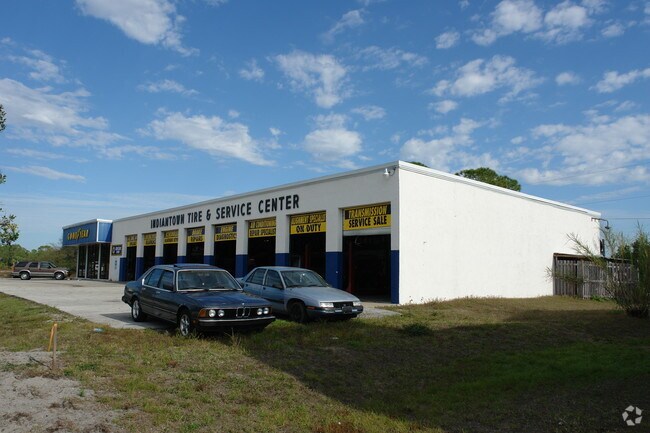
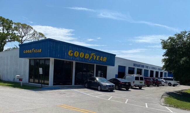
16087 Sw Warfield Blvd
Port St Lucie, FL
Indiantown Plat A
06-40-39-000-000-00013-6
PARCEL LYING IN N 1/2 SEC 6 T40S R39E: BEG AT WLY COR LOT 6 BLK 11 INDIANTOWN PLAT A NE 225 NW 200 SW 215 TO N R/W SR 710 AS IN OR 1060/2020 SE 36.21 SW 10 SE 163.79 TO POB INDIANTOWN GOODYEAR
Commercialnec
Martin
X
Florida
12085C0265G
6
2024
1.02 AC
2025
Martin Inland
001804
Port St Lucie/Fort Pierce
7,250 SF
DEMOGRAPHICS near 16087 Sw Warfield Blvd
1 Mile
3 Mile
5 Mile
2024 Total Population
4,886
6,343
7,152
2029 Population
5,043
6,549
7,395
Pop Growth 2024-2029
+ 3.21%
+ 3.25%
+ 3.40%
Average Age
36
35
35
2024 Total Households
1,369
1,729
1,947
HH Growth 2024-2029
+ 3.43%
+ 3.30%
+ 3.54%
Median Household Inc
$43,002
$42,577
$42,500
Avg Household Size
3.30
3.40
3.30
2024 Avg HH Vehicles
2.00
2.00
2.00
Median Home Value
$90,115
$102,362
$107,711
Median Year Built
1984
1983
1983
Nearby Places
- Restaurants
- Banks
- Shops
- Fitness
- Groceries
PUBLIC TRANSPORTATION
AIRPORT
Palm Beach International
DRIVE
WALK
Distance
Palm Beach International
56 min
38.5 mi
Freight Ports
Port of Palm Beach
DRIVE
WALK
Distance
Port of Palm Beach
49 min
32.2 mi
SALE & LEASE HISTORY
LISTING DATE
SALE/LEASE

Jun 19, 2023
For Sale
Nearby Properties
Address
Land Use
TOTAL SIZE
Lot Size
Zoning
Address
Land Use
TOTAL SIZE
Lot Size
Zoning
206,889 SF
76.77 AC
GI
Address
Land Use
TOTAL SIZE
Lot Size
Zoning
10.39 AC
Address
Land Use
TOTAL SIZE
Lot Size
Zoning
144.69 AC
M3
Address
Land Use
TOTAL SIZE
Lot Size
Zoning
105,069 SF
11.30 AC
PS
Address
Land Use
TOTAL SIZE
Lot Size
Zoning
19.39 AC
WGC
Address
Land Use
TOTAL SIZE
Lot Size
Zoning
149.83 AC
Address
Land Use
TOTAL SIZE
Lot Size
Zoning
29.42 AC
PUDC
Address
Land Use
TOTAL SIZE
Lot Size
Zoning
35,723 SF
20 AC
RS6
Address
Land Use
TOTAL SIZE
Lot Size
Zoning
1.60 AC
RM10
Address
Land Use
TOTAL SIZE
Lot Size
Zoning
36,305 SF
3.30 AC
B1
Address
Land Use
TOTAL SIZE
Lot Size
Zoning
80,279 SF
10.59 AC
M1
Address
Land Use
TOTAL SIZE
Lot Size
Zoning
Address
Land Use
TOTAL SIZE
Lot Size
Zoning
563.93 AC
AG20A
Address
Land Use
TOTAL SIZE
Lot Size
Zoning
22,014 SF
0.79 AC
Address
Land Use
TOTAL SIZE
Lot Size
Zoning
1,168 SF
28.75 AC
WGC
Address
Land Use
TOTAL SIZE
Lot Size
Zoning
Address
Land Use
TOTAL SIZE
Lot Size
Zoning
56,333 SF
18.86 AC
RM8
Address
Land Use
TOTAL SIZE
Lot Size
Zoning
83,829 SF
20 AC
PS
Address
Land Use
TOTAL SIZE
Lot Size
Zoning
13,380 SF
2.89 AC
B2
Address
Land Use
TOTAL SIZE
Lot Size
Zoning
Address
Land Use
TOTAL SIZE
Lot Size
Zoning
18,138 SF
213.55 AC
PUDI
Address
Land Use
TOTAL SIZE
Lot Size
Zoning
19,485 SF
10.28 AC
PS
Address
Land Use
TOTAL SIZE
Lot Size
Zoning
10,359 SF
2.79 AC
B1
Address
Land Use
TOTAL SIZE
Lot Size
Zoning
145.40 AC
Address
Land Use
TOTAL SIZE
Lot Size
Zoning
18.73 AC
WGC
Address
Land Use
TOTAL SIZE
Lot Size
Zoning
7,223 SF
37.49 AC
E1
Address
Land Use
TOTAL SIZE
Lot Size
Zoning
18,615 SF
1.41 AC
B1
Address
Land Use
TOTAL SIZE
Lot Size
Zoning
10,092 SF
1.47 AC
Address
Land Use
TOTAL SIZE
Lot Size
Zoning
Address
Land Use
TOTAL SIZE
Lot Size
Zoning
62.57 AC
The World's #1 Commercial Real Estate Marketplace
Connect with us
© 2025 CoStar Group
The information above has been obtained from sources believed reliable. While we do not doubt its accuracy we have not verified it and make no guarantee, warranty or representation about it. It is your responsibility to independently confirm its accuracy and completeness. Any projections, opinions, assumptions, or estimates used are for example only and do not represent the current or future performance of the property. The value of this transaction to you depends on tax and other factors which should be evaluated by your tax, financial, and legal advisors. You and your advisors should conduct a careful, independent investigation of the property to determine to your satisfaction the suitability of the property for your needs.