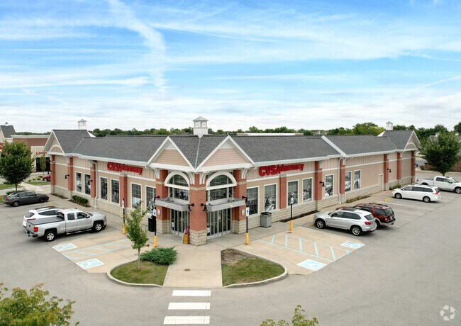
Property Record
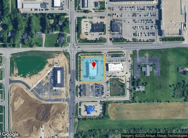
16088 Spring Mill Station Dr, Westfield, IN 46074
NEARBY LISTINGS FOR SALE OR LEASE
Property Detail
16088 Spring Mill Station Dr
Indianapolis-Carmel-Greenwood, IN
Springmill Station Se Corner
29-09-11-027-001.000-015
ACREAGE 1.32, SECTION 11, TOWNSHIP 18, RANGE 3, SPRINGMILL STATION SE CORNER, LOT 1, IRREGULAR SHAPE
Storebuilding
Hamilton
X
Indiana
18057C0120G
1
2023
1.32 AC
2024
Carmel
110406
Indianapolis
13,273 SF
DEMOGRAPHICS near 16088 Spring Mill Station Dr
1 Mile
3 Mile
5 Mile
2024 Total Population
9,376
55,873
128,754
2029 Population
10,421
63,518
146,373
Pop Growth 2024-2029
+ 11.15%
+ 13.68%
+ 13.68%
Average Age
36
38
38
2024 Total Households
3,118
19,875
47,948
HH Growth 2024-2029
+ 11.10%
+ 13.70%
+ 13.77%
Median Household Inc
$115,593
$109,736
$105,952
Avg Household Size
3.00
2.80
2.60
2024 Avg HH Vehicles
2.00
2.00
2.00
Median Home Value
$333,289
$363,505
$378,304
Median Year Built
2004
2004
2004
Nearby Places
Map Layers
Map Styles
 Street
 Aerial
- Restaurants
- Banks
- Shops
- Fitness
- Groceries
PUBLIC TRANSPORTATION
AIRPORT
Indianapolis International
DRIVE
WALK
Distance
Indianapolis International
55 min
33.3 mi
Freight Ports
Port of Toledo
DRIVE
WALK
Distance
Port of Toledo
265 min
218.3 mi
Nearby Properties
Address
Land Use
TOTAL SIZE
Lot Size
Zoning
Address
Land Use
TOTAL SIZE
Lot Size
Zoning
27,385 SF
77.27 AC
Address
Land Use
TOTAL SIZE
Lot Size
Zoning
504,699 SF
40 AC
Address
Land Use
TOTAL SIZE
Lot Size
Zoning
383,016 SF
16.62 AC
Address
Land Use
TOTAL SIZE
Lot Size
Zoning
328,692 SF
12 AC
Address
Land Use
TOTAL SIZE
Lot Size
Zoning
236,320 SF
20.74 AC
Address
Land Use
TOTAL SIZE
Lot Size
Zoning
280,428 SF
12.81 AC
Address
Land Use
TOTAL SIZE
Lot Size
Zoning
388,202 SF
23.97 AC
Address
Land Use
TOTAL SIZE
Lot Size
Zoning
245,922 SF
19.03 AC
Address
Land Use
TOTAL SIZE
Lot Size
Zoning
257,957 SF
9.06 AC
Address
Land Use
TOTAL SIZE
Lot Size
Zoning
6.46 AC
Address
Land Use
TOTAL SIZE
Lot Size
Zoning
318,922 SF
31.70 AC
Address
Land Use
TOTAL SIZE
Lot Size
Zoning
296,315 SF
17.65 AC
Address
Land Use
TOTAL SIZE
Lot Size
Zoning
97,726 SF
8.49 AC
Address
Land Use
TOTAL SIZE
Lot Size
Zoning
188,239 SF
11.15 AC
Address
Land Use
TOTAL SIZE
Lot Size
Zoning
228,713 SF
7.06 AC
Address
Land Use
TOTAL SIZE
Lot Size
Zoning
96,054 SF
9.88 AC
Address
Land Use
TOTAL SIZE
Lot Size
Zoning
145,444 SF
34.32 AC
Address
Land Use
TOTAL SIZE
Lot Size
Zoning
173,884 SF
14.07 AC
Address
Land Use
TOTAL SIZE
Lot Size
Zoning
281,397 SF
18.08 AC
Address
Land Use
TOTAL SIZE
Lot Size
Zoning
141,255 SF
21.61 AC
Address
Land Use
TOTAL SIZE
Lot Size
Zoning
231,080 SF
9.28 AC
Address
Land Use
TOTAL SIZE
Lot Size
Zoning
73,680 SF
19.08 AC
Address
Land Use
TOTAL SIZE
Lot Size
Zoning
87,040 SF
24.23 AC
Address
Land Use
TOTAL SIZE
Lot Size
Zoning
314,499 SF
12 AC
Address
Land Use
TOTAL SIZE
Lot Size
Zoning
147,081 SF
56.70 AC
Address
Land Use
TOTAL SIZE
Lot Size
Zoning
290,862 SF
2.54 AC
Address
Land Use
TOTAL SIZE
Lot Size
Zoning
130,356 SF
8.09 AC
Address
Land Use
TOTAL SIZE
Lot Size
Zoning
96,434 SF
6.05 AC
Address
Land Use
TOTAL SIZE
Lot Size
Zoning
129,005 SF
13.19 AC
Address
Land Use
TOTAL SIZE
Lot Size
Zoning
151,448 SF
10.58 AC
The World's #1 Commercial Real Estate Marketplace
Connect with us
© 2026 CoStar Group
The information above has been obtained from sources believed reliable. While we do not doubt its accuracy we have not verified it and make no guarantee, warranty or representation about it. It is your responsibility to independently confirm its accuracy and completeness. Any projections, opinions, assumptions, or estimates used are for example only and do not represent the current or future performance of the property. The value of this transaction to you depends on tax and other factors which should be evaluated by your tax, financial, and legal advisors. You and your advisors should conduct a careful, independent investigation of the property to determine to your satisfaction the suitability of the property for your needs.