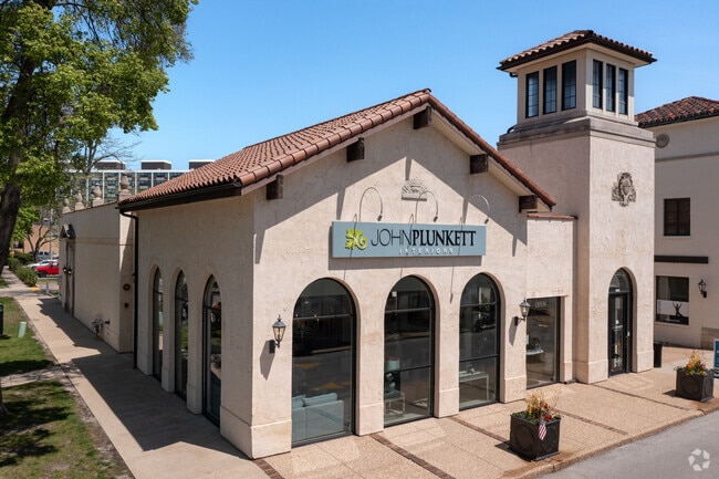
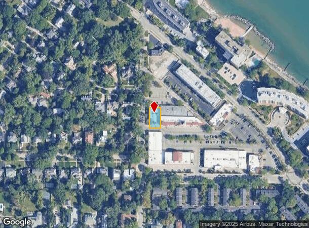
Property Record
1609 10Th St, Wilmette, IL 60091


NEARBY LISTINGS FOR SALE OR LEASE
Property Detail
1609 10Th St
Chicago-Naperville-Elgin, IL-IN-WI
Foufas - Stefan
05-27-201-029-0000
(FOUFAS)-(STEFAN) RESUB OF LTS 3,6-8,10-12 & PT LT9 I N SUB OF BLK1 &PT2 IN GAGES ADD WILMETTE SECS27&28 & LTS30-34 IN LAKOTA
Commercialbuilding
Cook
X
Illinois
17031C0254K
3,9-1
2023
0.17 AC
2024
Near North
801100
Chicago
DEMOGRAPHICS near 1609 10Th St
1 Mile
3 Mile
5 Mile
2024 Total Population
9,431
86,317
222,310
2029 Population
9,201
84,092
216,691
Pop Growth 2024-2029
(2.44%)
(2.58%)
(2.53%)
Average Age
42
40
41
2024 Total Households
3,293
30,405
82,231
HH Growth 2024-2029
(2.61%)
(2.75%)
(2.74%)
Median Household Inc
$212,151
$126,172
$100,003
Avg Household Size
2.80
2.60
2.50
2024 Avg HH Vehicles
2.00
2.00
2.00
Median Home Value
$992,452
$708,622
$486,618
Median Year Built
1948
1953
1955
Nearby Places
Map Layers
Map Styles
 Street
 Aerial
- Restaurants
- Banks
- Shops
- Fitness
- Groceries
PUBLIC TRANSPORTATION
COMMUTER RAIL
Wilmette Station (Union Pacific North Line - Northeast Illinois Regional Commuter Railroad (Metra))
DRIVE
WALK
Distance
Wilmette Station (Union Pacific North Line - Northeast Illinois Regional Commuter Railroad (Metra))
2 min
18 min
0.9 mi
Kenilworth Station (Union Pacific North Line - Northeast Illinois Regional Commuter Railroad (Metra))
DRIVE
WALK
Distance
Kenilworth Station (Union Pacific North Line - Northeast Illinois Regional Commuter Railroad (Metra))
2 min
18 min
1.0 mi
AIRPORT
Chicago O'Hare International
DRIVE
WALK
Distance
Chicago O'Hare International
30 min
15.4 mi
Chicago Midway International
DRIVE
WALK
Distance
Chicago Midway International
43 min
26.3 mi
Freight Ports
Port Milwaukee
DRIVE
WALK
Distance
Port Milwaukee
87 min
70.3 mi
Nearby Properties
Address
Land Use
TOTAL SIZE
Lot Size
Zoning
Address
Land Use
TOTAL SIZE
Lot Size
Zoning
180,397 SF
0.78 AC
Address
Land Use
TOTAL SIZE
Lot Size
Zoning
0.63 AC
Address
Land Use
TOTAL SIZE
Lot Size
Zoning
341,698 SF
0.64 AC
Address
Land Use
TOTAL SIZE
Lot Size
Zoning
2.10 AC
Address
Land Use
TOTAL SIZE
Lot Size
Zoning
218,982 SF
1.97 AC
Address
Land Use
TOTAL SIZE
Lot Size
Zoning
172,538 SF
5.60 AC
Address
Land Use
TOTAL SIZE
Lot Size
Zoning
176,115 SF
1.04 AC
Address
Land Use
TOTAL SIZE
Lot Size
Zoning
0.84 AC
Address
Land Use
TOTAL SIZE
Lot Size
Zoning
110,528 SF
3.05 AC
Address
Land Use
TOTAL SIZE
Lot Size
Zoning
163,981 SF
4 AC
Address
Land Use
TOTAL SIZE
Lot Size
Zoning
5.65 AC
Address
Land Use
TOTAL SIZE
Lot Size
Zoning
145,548 SF
0.80 AC
Address
Land Use
TOTAL SIZE
Lot Size
Zoning
6.90 AC
Address
Land Use
TOTAL SIZE
Lot Size
Zoning
243,781 SF
0.84 AC
Address
Land Use
TOTAL SIZE
Lot Size
Zoning
0.30 AC
Address
Land Use
TOTAL SIZE
Lot Size
Zoning
0.84 AC
Address
Land Use
TOTAL SIZE
Lot Size
Zoning
0.38 AC
Address
Land Use
TOTAL SIZE
Lot Size
Zoning
0.25 AC
Address
Land Use
TOTAL SIZE
Lot Size
Zoning
0.21 AC
Address
Land Use
TOTAL SIZE
Lot Size
Zoning
172,544 SF
7.22 AC
Address
Land Use
TOTAL SIZE
Lot Size
Zoning
71,059 SF
0.79 AC
Address
Land Use
TOTAL SIZE
Lot Size
Zoning
1.62 AC
Address
Land Use
TOTAL SIZE
Lot Size
Zoning
76,101 SF
0.97 AC
Address
Land Use
TOTAL SIZE
Lot Size
Zoning
299,000 SF
0.34 AC
Address
Land Use
TOTAL SIZE
Lot Size
Zoning
59,476 SF
Address
Land Use
TOTAL SIZE
Lot Size
Zoning
0.30 AC
Address
Land Use
TOTAL SIZE
Lot Size
Zoning
90,000 SF
0.41 AC
Address
Land Use
TOTAL SIZE
Lot Size
Zoning
223,203 SF
3.75 AC
Address
Land Use
TOTAL SIZE
Lot Size
Zoning
0.48 AC
Address
Land Use
TOTAL SIZE
Lot Size
Zoning
128,366 SF
1 AC
The World's #1 Commercial Real Estate Marketplace
Connect with us
© 2025 CoStar Group
The information above has been obtained from sources believed reliable. While we do not doubt its accuracy we have not verified it and make no guarantee, warranty or representation about it. It is your responsibility to independently confirm its accuracy and completeness. Any projections, opinions, assumptions, or estimates used are for example only and do not represent the current or future performance of the property. The value of this transaction to you depends on tax and other factors which should be evaluated by your tax, financial, and legal advisors. You and your advisors should conduct a careful, independent investigation of the property to determine to your satisfaction the suitability of the property for your needs.