Property Record
1609 E Main St, Griffith, IN 46319
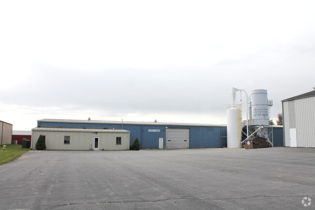

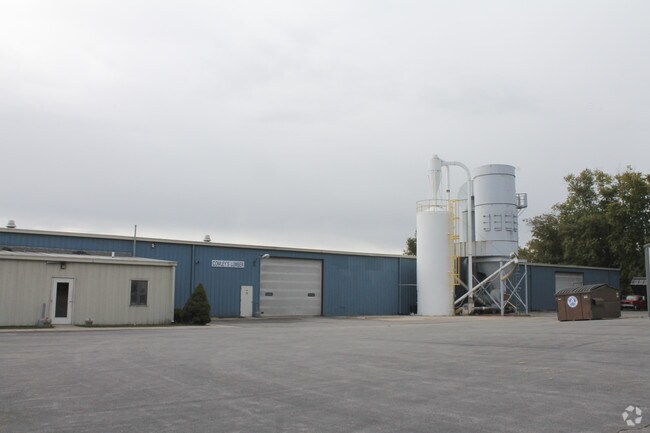
Property Detail
1609 E Main St
Chicago-Naperville-Elgin, IL-IN
COWLEYS ADDITION LOT 1
45-11-01-200-008.000-033
Lake
Industrialgeneral
Indiana
B and X Area of moderate flood hazard, usually the area between the limits of the 100-year and 500-year floods.
1
2024
2.81 AC
2025
Indiana
042602
Chicago
39,406 SF
NEARBY LISTINGS FOR SALE OR LEASE
DEMOGRAPHICS near 1609 E Main St
1 mile
3 mile
5 mile
2025 Total Population
1,854
48,679
164,808
2030 Population
1,884
48,813
166,797
Pop Growth 2025-2030
+ 1.62%
+ 0.28%
+ 1.21%
Average Age
43
40
41
2025 Total Households
757
19,322
66,546
HH Growth 2025-2030
+ 1.59%
+ 0.25%
+ 1.11%
Median Household Inc
$73,286
$72,910
$64,776
Avg Household Size
2.40
2.50
2.40
2025 Avg HH Vehicles
2.00
2.00
2.00
Median Home Value
$175,770
$217,251
$223,071
Median Year Built
1958
1968
1969
Nearby Places
Map Layers
Map Styles
 Street
 Aerial
Layers
 Traffic
 Biking
Places
Listings with unknown addresses are not visible on the map
- Restaurants
- Banks
- Shops
- Fitness
- Groceries
PUBLIC TRANSPORTATION
COMMUTER RAIL
Drive
Walk
Distance
17 min
6.6 mi
Clark Road (Gary) Station (South Shore Line - Northern Indiana Commuter Transportation District (South Shore Line))
Drive
Walk
Distance
Clark Road (Gary) Station (South Shore Line - Northern Indiana Commuter Transportation District (South Shore Line))
16 min
7.5 mi
AIRPORT
Chicago Midway International
Drive
Walk
Distance
Chicago Midway International
54 min
33.5 mi
Nearby Properties
Address
Land Use
TOTAL SIZE
Lot Size
Zoning
Address
Land Use
TOTAL SIZE
Lot Size
Zoning
132,147 SF
44.38 AC
R33
Address
Land Use
TOTAL SIZE
Lot Size
Zoning
105,000 SF
2.90 AC
Address
Land Use
TOTAL SIZE
Lot Size
Zoning
149,808 SF
15.07 AC
Address
Land Use
TOTAL SIZE
Lot Size
Zoning
34,116 SF
73.40 AC
Address
Land Use
TOTAL SIZE
Lot Size
Zoning
53,024 SF
43.30 AC
Address
Land Use
TOTAL SIZE
Lot Size
Zoning
159,134 SF
22 AC
Address
Land Use
TOTAL SIZE
Lot Size
Zoning
68.50 AC
Address
Land Use
TOTAL SIZE
Lot Size
Zoning
33,920 SF
83.34 AC
Address
Land Use
TOTAL SIZE
Lot Size
Zoning
44,960 SF
4.80 AC
Address
Land Use
TOTAL SIZE
Lot Size
Zoning
111,363 SF
9.60 AC
Address
Land Use
TOTAL SIZE
Lot Size
Zoning
14,501 SF
70.85 AC
Address
Land Use
TOTAL SIZE
Lot Size
Zoning
239,769 SF
20.94 AC
Address
Land Use
TOTAL SIZE
Lot Size
Zoning
24,964 SF
3.72 AC
Address
Land Use
TOTAL SIZE
Lot Size
Zoning
92,259 SF
6.41 AC
Address
Land Use
TOTAL SIZE
Lot Size
Zoning
88,434 SF
5 AC
Address
Land Use
TOTAL SIZE
Lot Size
Zoning
45,022 SF
6.02 AC
Address
Land Use
TOTAL SIZE
Lot Size
Zoning
28,674 SF
6.87 AC
Address
Land Use
TOTAL SIZE
Lot Size
Zoning
40,930 SF
4.82 AC
Address
Land Use
TOTAL SIZE
Lot Size
Zoning
86,292 SF
3.84 AC
Address
Land Use
TOTAL SIZE
Lot Size
Zoning
41,172 SF
1.56 AC
Address
Land Use
TOTAL SIZE
Lot Size
Zoning
5,287 SF
47.65 AC
Address
Land Use
TOTAL SIZE
Lot Size
Zoning
71,997 SF
2.69 AC
Address
Land Use
TOTAL SIZE
Lot Size
Zoning
73,800 SF
13.02 AC
Address
Land Use
TOTAL SIZE
Lot Size
Zoning
16,800 SF
6.07 AC
Address
Land Use
TOTAL SIZE
Lot Size
Zoning
8,250 SF
1.84 AC
Address
Land Use
TOTAL SIZE
Lot Size
Zoning
13,905 SF
1.76 AC
Address
Land Use
TOTAL SIZE
Lot Size
Zoning
16,229 SF
11.42 AC
Address
Land Use
TOTAL SIZE
Lot Size
Zoning
84,904 SF
3.64 AC
Address
Land Use
TOTAL SIZE
Lot Size
Zoning
39,892 SF
2.46 AC
Address
Land Use
TOTAL SIZE
Lot Size
Zoning
39,833 SF
6.28 AC
The World's #1 Commercial Real Estate Marketplace
Connect with us
© 2026 CoStar Group
The information above has been obtained from sources believed reliable. While we do not doubt its accuracy we have not verified it and make no guarantee, warranty or representation about it. It is your responsibility to independently confirm its accuracy and completeness. Any projections, opinions, assumptions, or estimates used are for example only and do not represent the current or future performance of the property. The value of this transaction to you depends on tax and other factors which should be evaluated by your tax, financial, and legal advisors. You and your advisors should conduct a careful, independent investigation of the property to determine to your satisfaction the suitability of the property for your needs.