Property Record
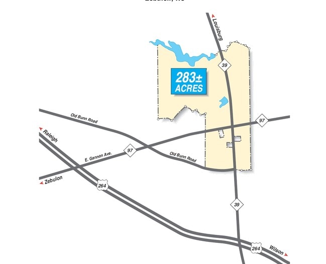
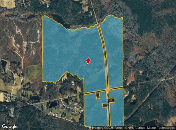
1609 Nc Highway 97 E, Zebulon, NC 27597
NEARBY LISTINGS FOR SALE OR LEASE
Property Detail
1609 Nc Highway 97 E
2715.02-58-9125-000
BUNN LAND
Timberlandforesttreesagricultural
Wake
AE
North Carolina
3720271600L
285.26 AC
2025
Northeast Wake County
2025
Raleigh/Durham
054304
Raleigh, NC
1,040 SF
DEMOGRAPHICS near 1609 Nc Highway 97 E
1 Mile
3 Mile
5 Mile
2024 Total Population
229
8,832
24,583
2029 Population
257
9,996
27,748
Pop Growth 2024-2029
+ 12.23%
+ 13.18%
+ 12.87%
Average Age
41
41
40
2024 Total Households
87
3,292
9,112
HH Growth 2024-2029
+ 12.64%
+ 13.18%
+ 12.88%
Median Household Inc
$75,781
$76,312
$70,185
Avg Household Size
2.60
2.70
2.70
2024 Avg HH Vehicles
2.00
2.00
2.00
Median Home Value
$388,888
$331,324
$251,337
Median Year Built
1988
1992
1995
Nearby Places
Map Layers
Map Styles
 Street
 Aerial
- Restaurants
- Banks
- Shops
- Fitness
- Groceries
PUBLIC TRANSPORTATION
AIRPORT
Raleigh-Durham International
DRIVE
WALK
Distance
Raleigh-Durham International
47 min
35.7 mi
Freight Ports
Port of Wilmington
DRIVE
WALK
Distance
Port of Wilmington
165 min
141.2 mi
Nearby Properties
Address
Land Use
TOTAL SIZE
Lot Size
Zoning
Address
Land Use
TOTAL SIZE
Lot Size
Zoning
684,322 SF
128.05 AC
LI
Address
Land Use
TOTAL SIZE
Lot Size
Zoning
403,424 SF
45.13 AC
LI
Address
Land Use
TOTAL SIZE
Lot Size
Zoning
169,147 SF
18.48 AC
OI
Address
Land Use
TOTAL SIZE
Lot Size
Zoning
102,726 SF
33.59 AC
OI
Address
Land Use
TOTAL SIZE
Lot Size
Zoning
193,130 SF
24.71 AC
HC
Address
Land Use
TOTAL SIZE
Lot Size
Zoning
267,518 SF
16.18 AC
HI
Address
Land Use
TOTAL SIZE
Lot Size
Zoning
83,419 SF
23.80 AC
R2
Address
Land Use
TOTAL SIZE
Lot Size
Zoning
151,485 SF
9.45 AC
HI
Address
Land Use
TOTAL SIZE
Lot Size
Zoning
33,656 SF
52.02 AC
CA-SU
Address
Land Use
TOTAL SIZE
Lot Size
Zoning
152,062 SF
8.80 AC
HI
Address
Land Use
TOTAL SIZE
Lot Size
Zoning
120,504 SF
13.76 AC
HC
Address
Land Use
TOTAL SIZE
Lot Size
Zoning
27,378 SF
12.71 AC
OI
Address
Land Use
TOTAL SIZE
Lot Size
Zoning
30,800 SF
3.79 AC
HC
Address
Land Use
TOTAL SIZE
Lot Size
Zoning
34,280 SF
5.41 AC
OI
Address
Land Use
TOTAL SIZE
Lot Size
Zoning
148,004 SF
8.80 AC
HI
Address
Land Use
TOTAL SIZE
Lot Size
Zoning
74,750 SF
5.69 AC
LI
Address
Land Use
TOTAL SIZE
Lot Size
Zoning
49,788 SF
2.61 AC
LI
Address
Land Use
TOTAL SIZE
Lot Size
Zoning
67,103 SF
8.38 AC
HI
Address
Land Use
TOTAL SIZE
Lot Size
Zoning
14,459 SF
1.31 AC
DTP
Address
Land Use
TOTAL SIZE
Lot Size
Zoning
4,733 SF
3.40 AC
HC
Address
Land Use
TOTAL SIZE
Lot Size
Zoning
21,868 SF
1.77 AC
DTP
Address
Land Use
TOTAL SIZE
Lot Size
Zoning
15,780 SF
1.01 AC
DTP
Address
Land Use
TOTAL SIZE
Lot Size
Zoning
21,820 SF
3.27 AC
HC
Address
Land Use
TOTAL SIZE
Lot Size
Zoning
44,265 SF
3.93 AC
RMF-S
Address
Land Use
TOTAL SIZE
Lot Size
Zoning
6,580 SF
2.41 AC
OI
Address
Land Use
TOTAL SIZE
Lot Size
Zoning
45,000 SF
6.99 AC
LI
Address
Land Use
TOTAL SIZE
Lot Size
Zoning
2,184 SF
45.36 AC
DTP
Address
Land Use
TOTAL SIZE
Lot Size
Zoning
15,575 SF
3.26 AC
R2
Address
Land Use
TOTAL SIZE
Lot Size
Zoning
118.30 AC
PD
The World's #1 Commercial Real Estate Marketplace
Connect with us
© 2026 CoStar Group
The information above has been obtained from sources believed reliable. While we do not doubt its accuracy we have not verified it and make no guarantee, warranty or representation about it. It is your responsibility to independently confirm its accuracy and completeness. Any projections, opinions, assumptions, or estimates used are for example only and do not represent the current or future performance of the property. The value of this transaction to you depends on tax and other factors which should be evaluated by your tax, financial, and legal advisors. You and your advisors should conduct a careful, independent investigation of the property to determine to your satisfaction the suitability of the property for your needs.