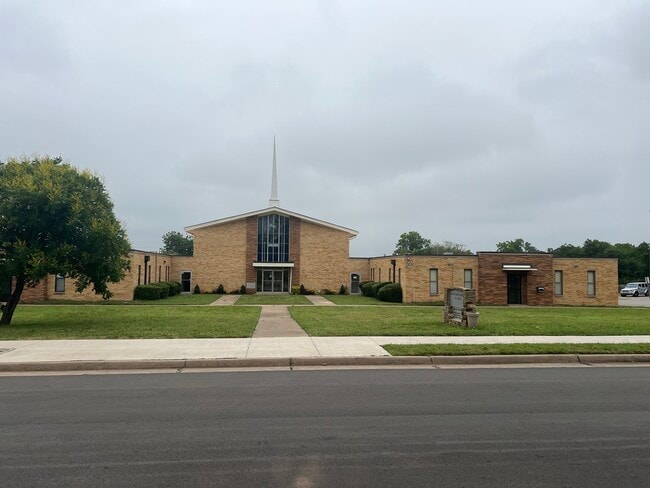
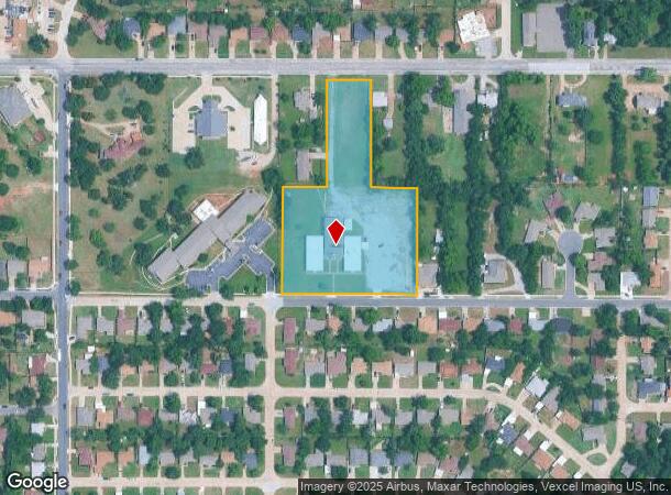
Property Record
1609 Ne 48Th St, Oklahoma City, OK 73111
Current Lease Availabilities
NEARBY LISTINGS FOR SALE OR LEASE
Property Detail
1609 Ne 48Th St
146398000
Lincoln View Second
Religious
LINCOLN VIEW SECOND 000 000 W65FT OF S/2 OF BLK 29 & N/2 OF E132FT OF W264FT IN BLK 30 & S/2 OF BLK 30
X
Oklahoma
40109C0190H
Oklahoma
0
7.54 AC
2024
North
105202
Oklahoma City
23,800 SF
Oklahoma City, OK
DEMOGRAPHICS near 1609 Ne 48Th St
1 Mile
3 Mile
5 Mile
2024 Total Population
4,412
37,364
118,264
2029 Population
4,520
38,769
122,409
Pop Growth 2024-2029
+ 2.45%
+ 3.76%
+ 3.50%
Average Age
43
40
38
2024 Total Households
1,875
17,350
53,767
HH Growth 2024-2029
+ 2.45%
+ 3.85%
+ 3.58%
Median Household Inc
$35,438
$40,703
$49,509
Avg Household Size
2.30
2.00
2.10
2024 Avg HH Vehicles
2.00
2.00
2.00
Median Home Value
$102,164
$171,351
$187,030
Median Year Built
1957
1953
1958
Nearby Places
Map Layers
Map Styles
 Street
 Aerial
- Restaurants
- Banks
- Shops
- Fitness
- Groceries
PUBLIC TRANSPORTATION
COMMUTER RAIL
DRIVE
WALK
Distance
12 min
5.4 mi
AIRPORT
Will Rogers World
DRIVE
WALK
Distance
Will Rogers World
30 min
16.0 mi
Nearby Properties
Address
Land Use
TOTAL SIZE
Lot Size
Zoning
Address
Land Use
TOTAL SIZE
Lot Size
Zoning
101,216 SF
1.23 AC
Address
Land Use
TOTAL SIZE
Lot Size
Zoning
442,553 SF
58.86 AC
PUD
Address
Land Use
TOTAL SIZE
Lot Size
Zoning
58,071 SF
4.15 AC
PUD
Address
Land Use
TOTAL SIZE
Lot Size
Zoning
327,248 SF
14.22 AC
R-4
Address
Land Use
TOTAL SIZE
Lot Size
Zoning
93,244 SF
7.54 AC
PUD
Address
Land Use
TOTAL SIZE
Lot Size
Zoning
377,880 SF
24.34 AC
PUD
Address
Land Use
TOTAL SIZE
Lot Size
Zoning
258,381 SF
2.54 AC
PUD
Address
Land Use
TOTAL SIZE
Lot Size
Zoning
254,126 SF
2.11 AC
SPUD
Address
Land Use
TOTAL SIZE
Lot Size
Zoning
21,000 SF
2.64 AC
I-1
Address
Land Use
TOTAL SIZE
Lot Size
Zoning
280,970 SF
24.32 AC
Address
Land Use
TOTAL SIZE
Lot Size
Zoning
189,504 SF
5.74 AC
Address
Land Use
TOTAL SIZE
Lot Size
Zoning
436,316 SF
5.23 AC
I-1
Address
Land Use
TOTAL SIZE
Lot Size
Zoning
39,800 SF
4.10 AC
PUD
Address
Land Use
TOTAL SIZE
Lot Size
Zoning
1 SF
3.72 AC
C-3
Address
Land Use
TOTAL SIZE
Lot Size
Zoning
198,422 SF
4.17 AC
O-2
Address
Land Use
TOTAL SIZE
Lot Size
Zoning
142,592 SF
6.60 AC
PUD
Address
Land Use
TOTAL SIZE
Lot Size
Zoning
39,883 SF
2.35 AC
PUD
Address
Land Use
TOTAL SIZE
Lot Size
Zoning
160,849 SF
11.65 AC
C-3
Address
Land Use
TOTAL SIZE
Lot Size
Zoning
181,760 SF
9.17 AC
I-2
Address
Land Use
TOTAL SIZE
Lot Size
Zoning
36,251 SF
6.21 AC
Address
Land Use
TOTAL SIZE
Lot Size
Zoning
66,965 SF
14.76 AC
SPUD
Address
Land Use
TOTAL SIZE
Lot Size
Zoning
14,431 SF
0.80 AC
PUD
Address
Land Use
TOTAL SIZE
Lot Size
Zoning
71,972 SF
9.73 AC
PUD
Address
Land Use
TOTAL SIZE
Lot Size
Zoning
375,793 SF
11.92 AC
I-2
Address
Land Use
TOTAL SIZE
Lot Size
Zoning
151,319 SF
3.43 AC
O-2
Address
Land Use
TOTAL SIZE
Lot Size
Zoning
171,139 SF
11.06 AC
I-2
Address
Land Use
TOTAL SIZE
Lot Size
Zoning
32,252 SF
3.33 AC
PUD
Address
Land Use
TOTAL SIZE
Lot Size
Zoning
129,935 SF
5.42 AC
PUD
Address
Land Use
TOTAL SIZE
Lot Size
Zoning
134,213 SF
5.81 AC
C-3
The World's #1 Commercial Real Estate Marketplace
Connect with us
© 2026 CoStar Group
The information above has been obtained from sources believed reliable. While we do not doubt its accuracy we have not verified it and make no guarantee, warranty or representation about it. It is your responsibility to independently confirm its accuracy and completeness. Any projections, opinions, assumptions, or estimates used are for example only and do not represent the current or future performance of the property. The value of this transaction to you depends on tax and other factors which should be evaluated by your tax, financial, and legal advisors. You and your advisors should conduct a careful, independent investigation of the property to determine to your satisfaction the suitability of the property for your needs.