Property Record
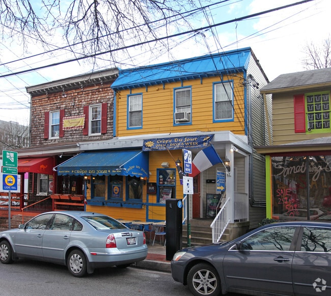
1609 Sulgrave Ave, Baltimore, MD 21209


This Property Is For Sale
NEARBY LISTINGS FOR SALE OR LEASE
Property Detail
1609 Sulgrave Ave
Baltimore-Columbia-Towson, MD
Mt Washington
4700A-015
25X150
Restaurantbuilding
Baltimore City
AE
Maryland
2400100385G
15
2024
0.09 AC
2025
Baltimore Northwest
271501
Baltimore
1,806 SF
DEMOGRAPHICS near 1609 Sulgrave Ave
1 Mile
3 Mile
5 Mile
2024 Total Population
6,820
140,621
416,597
2029 Population
6,476
135,446
405,445
Pop Growth 2024-2029
(5.04%)
(3.68%)
(2.68%)
Average Age
44
40
41
2024 Total Households
3,152
56,422
174,579
HH Growth 2024-2029
(5.17%)
(3.99%)
(2.88%)
Median Household Inc
$99,341
$73,056
$61,211
Avg Household Size
2.10
2.30
2.20
2024 Avg HH Vehicles
2.00
1.00
1.00
Median Home Value
$468,088
$324,696
$265,545
Median Year Built
1962
1955
1954
Nearby Places
Map Layers
Map Styles
 Street
 Aerial
- Restaurants
- Banks
- Shops
- Fitness
- Groceries
PUBLIC TRANSPORTATION
TRANSIT/SUBWAY
Mount Washington (Hunt Valley & BWI Marshall - Maryland Transit Administration Light Rail (Baltimore Light Rail), Timonium & Cromwell - Maryland Transit Administration Light Rail (Baltimore Light Rail))
DRIVE
WALK
Distance
Mount Washington (Hunt Valley & BWI Marshall - Maryland Transit Administration Light Rail (Baltimore Light Rail), Timonium & Cromwell - Maryland Transit Administration Light Rail (Baltimore Light Rail))
0 min
2 min
0.1 mi
Falls Road (Hunt Valley & BWI Marshall - Maryland Transit Administration Light Rail (Baltimore Light Rail), Timonium & Cromwell - Maryland Transit Administration Light Rail (Baltimore Light Rail))
DRIVE
WALK
Distance
Falls Road (Hunt Valley & BWI Marshall - Maryland Transit Administration Light Rail (Baltimore Light Rail), Timonium & Cromwell - Maryland Transit Administration Light Rail (Baltimore Light Rail))
4 min
18 min
0.9 mi
COMMUTER RAIL
Penn Station (PENN - WASHINGTON - Maryland Area Regional Commuter Trains (The MARC), Penn Line - Maryland Area Regional Commuter Trains (The MARC), Penn Station & Camden Yards - Maryland Area Regional Commuter Trains (The MARC))
DRIVE
WALK
Distance
Penn Station (PENN - WASHINGTON - Maryland Area Regional Commuter Trains (The MARC), Penn Line - Maryland Area Regional Commuter Trains (The MARC), Penn Station & Camden Yards - Maryland Area Regional Commuter Trains (The MARC))
12 min
6.0 mi
West Baltimore (PENN - WASHINGTON - Maryland Area Regional Commuter Trains (The MARC), Penn Line - Maryland Area Regional Commuter Trains (The MARC))
DRIVE
WALK
Distance
West Baltimore (PENN - WASHINGTON - Maryland Area Regional Commuter Trains (The MARC), Penn Line - Maryland Area Regional Commuter Trains (The MARC))
18 min
7.7 mi
AIRPORT
Baltimore/Washington International Thurgood Marshall
DRIVE
WALK
Distance
Baltimore/Washington International Thurgood Marshall
32 min
17.7 mi
Freight Ports
Port of Baltimore
DRIVE
WALK
Distance
Port of Baltimore
22 min
9.9 mi
Nearby Properties
Address
Land Use
TOTAL SIZE
Lot Size
Zoning
Address
Land Use
TOTAL SIZE
Lot Size
Zoning
363,750 SF
87 SF
Address
Land Use
TOTAL SIZE
Lot Size
Zoning
1,165,880 SF
55.70 AC
DR2
Address
Land Use
TOTAL SIZE
Lot Size
Zoning
810,716 SF
28.88 AC
H
Address
Land Use
TOTAL SIZE
Lot Size
Zoning
1,228,117 SF
9.43 AC
C-2
Address
Land Use
TOTAL SIZE
Lot Size
Zoning
599,187 SF
30.14 AC
EC-2
Address
Land Use
TOTAL SIZE
Lot Size
Zoning
723,067 SF
80.37 AC
OR2
Address
Land Use
TOTAL SIZE
Lot Size
Zoning
23.09 AC
DR16
Address
Land Use
TOTAL SIZE
Lot Size
Zoning
34.99 AC
R-5
Address
Land Use
TOTAL SIZE
Lot Size
Zoning
567,521 SF
8.12 AC
R-9
Address
Land Use
TOTAL SIZE
Lot Size
Zoning
230,316 SF
9.93 AC
DR2
Address
Land Use
TOTAL SIZE
Lot Size
Zoning
543,281 SF
7.28 AC
C-2
Address
Land Use
TOTAL SIZE
Lot Size
Zoning
117,000 SF
71.11 AC
EC-2
Address
Land Use
TOTAL SIZE
Lot Size
Zoning
12.75 AC
DR16
Address
Land Use
TOTAL SIZE
Lot Size
Zoning
430,271 SF
56.35 AC
EC-2
Address
Land Use
TOTAL SIZE
Lot Size
Zoning
507,813 SF
4.94 AC
TOD-2
Address
Land Use
TOTAL SIZE
Lot Size
Zoning
211,229 SF
7.46 AC
R-9
Address
Land Use
TOTAL SIZE
Lot Size
Zoning
33.46 AC
DR16
Address
Land Use
TOTAL SIZE
Lot Size
Zoning
578,808 SF
30.10 AC
Address
Land Use
TOTAL SIZE
Lot Size
Zoning
27.30 AC
DR16
Address
Land Use
TOTAL SIZE
Lot Size
Zoning
367,920 SF
2.87 AC
R-9
Address
Land Use
TOTAL SIZE
Lot Size
Zoning
54.25 AC
EC-1
Address
Land Use
TOTAL SIZE
Lot Size
Zoning
15.49 AC
DR16
Address
Land Use
TOTAL SIZE
Lot Size
Zoning
245,951 SF
58.90 AC
EC-1
Address
Land Use
TOTAL SIZE
Lot Size
Zoning
1.15 AC
R-10
Address
Land Use
TOTAL SIZE
Lot Size
Zoning
814,033 SF
23.60 AC
OR-2
Address
Land Use
TOTAL SIZE
Lot Size
Zoning
117,680 SF
23.12 AC
H
Address
Land Use
TOTAL SIZE
Lot Size
Zoning
334,557 SF
52 AC
R-6
Address
Land Use
TOTAL SIZE
Lot Size
Zoning
24 AC
02
Address
Land Use
TOTAL SIZE
Lot Size
Zoning
289,194 SF
19.57 AC
H
Address
Land Use
TOTAL SIZE
Lot Size
Zoning
293,603 SF
13.54 AC
R-1-C
The World's #1 Commercial Real Estate Marketplace
Connect with us
© 2026 CoStar Group
The information above has been obtained from sources believed reliable. While we do not doubt its accuracy we have not verified it and make no guarantee, warranty or representation about it. It is your responsibility to independently confirm its accuracy and completeness. Any projections, opinions, assumptions, or estimates used are for example only and do not represent the current or future performance of the property. The value of this transaction to you depends on tax and other factors which should be evaluated by your tax, financial, and legal advisors. You and your advisors should conduct a careful, independent investigation of the property to determine to your satisfaction the suitability of the property for your needs.