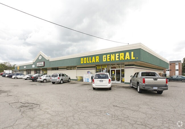
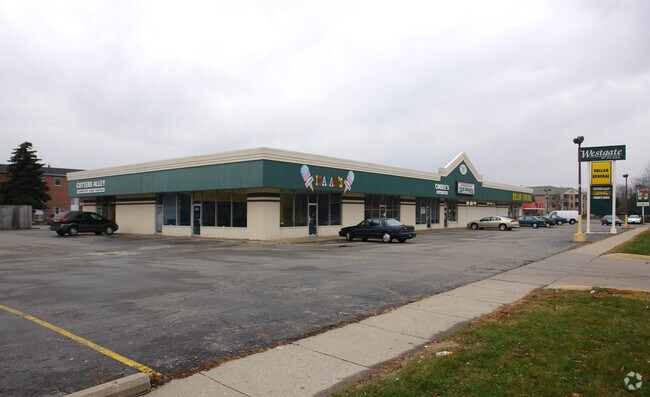
Property Record
1609 W Atherton Rd, Flint, MI 48507


Property Detail
1609 W Atherton Rd
40-25-201-056
GREENBROOK NLY 140 FT OF LOT 37 EXC ELY 288 FT; ALSO EXC NLY 130 FT OF WLY 130 FT, BLK 1 SPLIT ON 09/30/2020 FROM
Commercialnec
GENESEE
NC
Michigan
B and X Area of moderate flood hazard, usually the area between the limits of the 100-year and 500-year floods.
37
2025
0.92 AC
2025
Flint
011010
Detroit
14,040 SF
Flint, MI
NEARBY LISTINGS FOR SALE OR LEASE
DEMOGRAPHICS near 1609 W Atherton Rd
1 mile
3 mile
5 mile
2025 Total Population
10,296
66,886
137,618
2030 Population
10,320
67,220
138,423
Pop Growth 2025-2030
+ 0.23%
+ 0.50%
+ 0.58%
Average Age
38
39
40
2025 Total Households
4,335
28,124
58,271
HH Growth 2025-2030
+ 0.30%
+ 0.50%
+ 0.52%
Median Household Inc
$38,961
$46,217
$46,206
Avg Household Size
2.30
2.20
2.20
2025 Avg HH Vehicles
1.00
1.00
1.00
Median Home Value
$67,111
$89,022
$96,178
Median Year Built
1957
1958
1960
Nearby Places
Map Layers
Map Styles
 Street
 Aerial
Layers
 Traffic
 Biking
Places
Listings with unknown addresses are not visible on the map
- Restaurants
- Banks
- Shops
- Fitness
- Groceries
PUBLIC TRANSPORTATION
COMMUTER RAIL
Flint Amtrak Station (Blue Water - Amtrak)
Drive
Walk
Distance
Flint Amtrak Station (Blue Water - Amtrak)
9 min
4.4 mi
AIRPORT
Bishop International
Drive
Walk
Distance
Bishop International
21 min
7.9 mi
Freight Ports
Port of Toledo
Drive
Walk
Distance
Port of Toledo
134 min
112.2 mi
SALE & LEASE HISTORY
LISTING DATE
SALE/LEASE

Mar 23, 2017
For Lease
Nearby Properties
Address
Land Use
TOTAL SIZE
Lot Size
Zoning
Address
Land Use
TOTAL SIZE
Lot Size
Zoning
381,509 SF
371.45 AC
PC
Address
Land Use
TOTAL SIZE
Lot Size
Zoning
Address
Land Use
TOTAL SIZE
Lot Size
Zoning
911,140 SF
Address
Land Use
TOTAL SIZE
Lot Size
Zoning
120,487 SF
5.81 AC
PRC
Address
Land Use
TOTAL SIZE
Lot Size
Zoning
54,651 SF
3.06 AC
Address
Land Use
TOTAL SIZE
Lot Size
Zoning
130,291 SF
Address
Land Use
TOTAL SIZE
Lot Size
Zoning
112,232 SF
196 AC
Address
Land Use
TOTAL SIZE
Lot Size
Zoning
144,896 SF
0.23 AC
DC
Address
Land Use
TOTAL SIZE
Lot Size
Zoning
115,556 SF
2.50 AC
DE
Address
Land Use
TOTAL SIZE
Lot Size
Zoning
59,232 SF
3.65 AC
Address
Land Use
TOTAL SIZE
Lot Size
Zoning
100,000 SF
Address
Land Use
TOTAL SIZE
Lot Size
Zoning
100,750 SF
Address
Land Use
TOTAL SIZE
Lot Size
Zoning
247,555 SF
198 AC
Address
Land Use
TOTAL SIZE
Lot Size
Zoning
68,571 SF
0.81 AC
DC
Address
Land Use
TOTAL SIZE
Lot Size
Zoning
118,750 SF
21.26 AC
C-3A
Address
Land Use
TOTAL SIZE
Lot Size
Zoning
246,759 SF
19.03 AC
CC
Address
Land Use
TOTAL SIZE
Lot Size
Zoning
48,557 SF
2.99 AC
Address
Land Use
TOTAL SIZE
Lot Size
Zoning
236,340 SF
25.17 AC
CE
Address
Land Use
TOTAL SIZE
Lot Size
Zoning
11.22 AC
RM
Address
Land Use
TOTAL SIZE
Lot Size
Zoning
10,212 SF
2.60 AC
UC
Address
Land Use
TOTAL SIZE
Lot Size
Zoning
94,280 SF
48.79 AC
Address
Land Use
TOTAL SIZE
Lot Size
Zoning
2,321 SF
18.59 AC
M-1
Address
Land Use
TOTAL SIZE
Lot Size
Zoning
6,051 SF
3.82 AC
Address
Land Use
TOTAL SIZE
Lot Size
Zoning
85,697 SF
0.30 AC
DC
Address
Land Use
TOTAL SIZE
Lot Size
Zoning
209,058 SF
9.02 AC
Address
Land Use
TOTAL SIZE
Lot Size
Zoning
25,496 SF
5.33 AC
Address
Land Use
TOTAL SIZE
Lot Size
Zoning
131,641 SF
136 AC
Address
Land Use
TOTAL SIZE
Lot Size
Zoning
403,803 SF
252 AC
Address
Land Use
TOTAL SIZE
Lot Size
Zoning
46,308 SF
4.24 AC
Address
Land Use
TOTAL SIZE
Lot Size
Zoning
79,828 SF
6.48 AC
The World's #1 Commercial Real Estate Marketplace
Connect with us
© 2026 CoStar Group
The information above has been obtained from sources believed reliable. While we do not doubt its accuracy we have not verified it and make no guarantee, warranty or representation about it. It is your responsibility to independently confirm its accuracy and completeness. Any projections, opinions, assumptions, or estimates used are for example only and do not represent the current or future performance of the property. The value of this transaction to you depends on tax and other factors which should be evaluated by your tax, financial, and legal advisors. You and your advisors should conduct a careful, independent investigation of the property to determine to your satisfaction the suitability of the property for your needs.