Property Record
16090 Red Arrow Hwy, Union Pier, MI 49129

NEARBY LISTINGS FOR SALE OR LEASE
-
-
View all Union Pier listings for sale on LoopNet.com
Property Detail
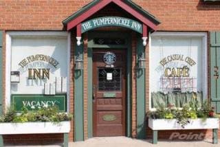
16090 Red Arrow Hwy
11-07-0125-0024-03-1
COM 1331.2'E OF S1/4 PST FRL SEC 25 T7S R21W TH N 148.75'TH E 17.1' TH S 7.65'TH S52DEG32'E 48.68'TH S 37DEG 04'W 64'TH S 60.4'TH W 17.06 FT TO POB
Storebuilding
Berrien
X
Michigan
26021C0330D
0.09 AC
2024
Michigan Southwest Area
2025
Other Market Areas
011201
Niles, MI
3,976 SF
DEMOGRAPHICS near 16090 Red Arrow Hwy
1 Mile
3 Mile
5 Mile
2024 Total Population
1,043
3,074
8,837
2029 Population
1,113
3,259
9,247
Pop Growth 2024-2029
+ 6.71%
+ 6.02%
+ 4.64%
Average Age
52
52
50
2024 Total Households
521
1,529
4,221
HH Growth 2024-2029
+ 6.53%
+ 5.95%
+ 4.71%
Median Household Inc
$74,999
$74,216
$68,942
Avg Household Size
2.00
2.00
2.10
2024 Avg HH Vehicles
2.00
2.00
2.00
Median Home Value
$433,945
$400,562
$316,527
Median Year Built
1976
1973
1969
Nearby Places
Map Layers
Map Styles
 Street
 Aerial
- Restaurants
- Banks
- Shops
- Fitness
- Groceries
PUBLIC TRANSPORTATION
COMMUTER RAIL
DRIVE
WALK
Distance
7 min
4.0 mi
AIRPORT
South Bend International
DRIVE
WALK
Distance
South Bend International
57 min
31.8 mi
SALE & LEASE HISTORY
LISTING DATE
SALE/LEASE

Oct 17, 2016
For Sale
Jun 04, 2018
For Sale
Nearby Properties
Address
Land Use
TOTAL SIZE
Lot Size
Zoning
Address
Land Use
TOTAL SIZE
Lot Size
Zoning
Address
Land Use
TOTAL SIZE
Lot Size
Zoning
14,542 SF
4.10 AC
R-1
Address
Land Use
TOTAL SIZE
Lot Size
Zoning
1.56 AC
Address
Land Use
TOTAL SIZE
Lot Size
Zoning
162 SF
161.16 AC
Address
Land Use
TOTAL SIZE
Lot Size
Zoning
0.63 AC
Address
Land Use
TOTAL SIZE
Lot Size
Zoning
4,660 SF
49.10 AC
Address
Land Use
TOTAL SIZE
Lot Size
Zoning
2,600 SF
34.89 AC
Address
Land Use
TOTAL SIZE
Lot Size
Zoning
7,632 SF
1.07 AC
R-1
Address
Land Use
TOTAL SIZE
Lot Size
Zoning
86.91 AC
Address
Land Use
TOTAL SIZE
Lot Size
Zoning
0.74 AC
R-1
Address
Land Use
TOTAL SIZE
Lot Size
Zoning
0.57 AC
R-1
Address
Land Use
TOTAL SIZE
Lot Size
Zoning
0.57 AC
R-1
Address
Land Use
TOTAL SIZE
Lot Size
Zoning
0.57 AC
R-1
Address
Land Use
TOTAL SIZE
Lot Size
Zoning
0.84 AC
Address
Land Use
TOTAL SIZE
Lot Size
Zoning
1.27 AC
Address
Land Use
TOTAL SIZE
Lot Size
Zoning
5.78 AC
Address
Land Use
TOTAL SIZE
Lot Size
Zoning
0.72 AC
Address
Land Use
TOTAL SIZE
Lot Size
Zoning
2,791 SF
62.43 AC
Address
Land Use
TOTAL SIZE
Lot Size
Zoning
60,475 SF
Address
Land Use
TOTAL SIZE
Lot Size
Zoning
2.76 AC
R-1
Address
Land Use
TOTAL SIZE
Lot Size
Zoning
3,721 SF
2.50 AC
GCD
Address
Land Use
TOTAL SIZE
Lot Size
Zoning
0.74 AC
R-1
Address
Land Use
TOTAL SIZE
Lot Size
Zoning
1.70 AC
R-1
Address
Land Use
TOTAL SIZE
Lot Size
Zoning
3.95 AC
Address
Land Use
TOTAL SIZE
Lot Size
Zoning
0.67 AC
SELECTZONI
Address
Land Use
TOTAL SIZE
Lot Size
Zoning
0.56 AC
SELECTZONI
Address
Land Use
TOTAL SIZE
Lot Size
Zoning
0.49 AC
R-1
Address
Land Use
TOTAL SIZE
Lot Size
Zoning
0.41 AC
R-1
Address
Land Use
TOTAL SIZE
Lot Size
Zoning
0.40 AC
R-1
Address
Land Use
TOTAL SIZE
Lot Size
Zoning
0.45 AC
R-1
The World's #1 Commercial Real Estate Marketplace
Connect with us
© 2026 CoStar Group
The information above has been obtained from sources believed reliable. While we do not doubt its accuracy we have not verified it and make no guarantee, warranty or representation about it. It is your responsibility to independently confirm its accuracy and completeness. Any projections, opinions, assumptions, or estimates used are for example only and do not represent the current or future performance of the property. The value of this transaction to you depends on tax and other factors which should be evaluated by your tax, financial, and legal advisors. You and your advisors should conduct a careful, independent investigation of the property to determine to your satisfaction the suitability of the property for your needs.