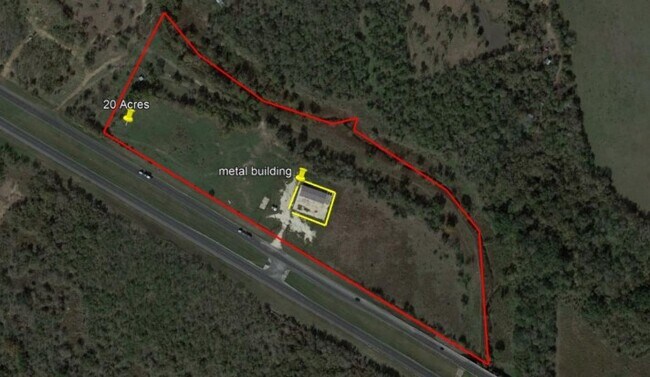
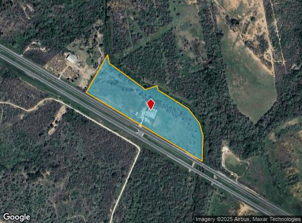
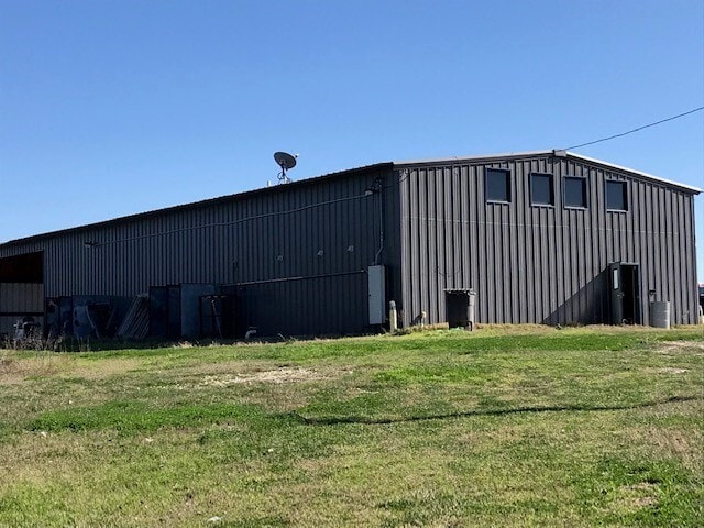
Property Record
16090 S Us Highway 181, San Antonio, TX 78223
NEARBY LISTINGS FOR SALE OR LEASE
Property Detail
16090 S Us Highway 181
San Antonio-New Braunfels, TX
Cb 4008A (Tcdp - Hwy 181)
04008-003-0665
CB 4008A (TCDP - HWY 181), BLOCK 13 LOT 1 REFER MH 82000-113-0010 2025 NEW ACCT PER PLAT 20003/1961
Gasolinefuelbulkstorage
Bexar
A
Texas
48029C0620G
1
2024
19.98 AC
2025
South
141900
San Antonio
12,022 SF
DEMOGRAPHICS near 16090 S Us Highway 181
1 Mile
3 Mile
5 Mile
2024 Total Population
430
5,742
13,048
2029 Population
457
6,373
14,621
Pop Growth 2024-2029
+ 6.28%
+ 10.99%
+ 12.06%
Average Age
42
41
42
2024 Total Households
156
2,030
4,583
HH Growth 2024-2029
+ 5.77%
+ 11.03%
+ 12.00%
Median Household Inc
$62,916
$59,938
$68,078
Avg Household Size
2.70
2.80
2.80
2024 Avg HH Vehicles
2.00
2.00
2.00
Median Home Value
$257,812
$208,639
$228,723
Median Year Built
1993
1995
1996
Nearby Places
Map Layers
Map Styles
 Street
 Aerial
- Restaurants
- Banks
- Shops
- Fitness
- Groceries
PUBLIC TRANSPORTATION
AIRPORT
San Antonio International
DRIVE
WALK
Distance
San Antonio International
30 min
24.7 mi
Freight Ports
Calhoun Port
DRIVE
WALK
Distance
Calhoun Port
166 min
136.3 mi
SALE & LEASE HISTORY
LISTING DATE
SALE/LEASE

Mar 16, 2021
For Sale
Nearby Properties
Address
Land Use
TOTAL SIZE
Lot Size
Zoning
Address
Land Use
TOTAL SIZE
Lot Size
Zoning
558.11 AC
Address
Land Use
TOTAL SIZE
Lot Size
Zoning
Address
Land Use
TOTAL SIZE
Lot Size
Zoning
Address
Land Use
TOTAL SIZE
Lot Size
Zoning
87,360 SF
9 AC
Address
Land Use
TOTAL SIZE
Lot Size
Zoning
208,764 SF
11.50 AC
Address
Land Use
TOTAL SIZE
Lot Size
Zoning
56,225 SF
13.57 AC
Address
Land Use
TOTAL SIZE
Lot Size
Zoning
99.35 AC
Address
Land Use
TOTAL SIZE
Lot Size
Zoning
Address
Land Use
TOTAL SIZE
Lot Size
Zoning
27,470 SF
5.20 AC
Address
Land Use
TOTAL SIZE
Lot Size
Zoning
1,383 SF
71.40 AC
Address
Land Use
TOTAL SIZE
Lot Size
Zoning
Address
Land Use
TOTAL SIZE
Lot Size
Zoning
Address
Land Use
TOTAL SIZE
Lot Size
Zoning
15,916 SF
3.19 AC
Address
Land Use
TOTAL SIZE
Lot Size
Zoning
1,890 SF
63.67 AC
Address
Land Use
TOTAL SIZE
Lot Size
Zoning
85.36 AC
Address
Land Use
TOTAL SIZE
Lot Size
Zoning
28,500 SF
7.65 AC
Address
Land Use
TOTAL SIZE
Lot Size
Zoning
13,411 SF
5.15 AC
Address
Land Use
TOTAL SIZE
Lot Size
Zoning
1,140 SF
10.06 AC
Address
Land Use
TOTAL SIZE
Lot Size
Zoning
9,020 SF
1.88 AC
Address
Land Use
TOTAL SIZE
Lot Size
Zoning
7,063 SF
3.35 AC
Address
Land Use
TOTAL SIZE
Lot Size
Zoning
95.50 AC
Address
Land Use
TOTAL SIZE
Lot Size
Zoning
952 SF
86.94 AC
Address
Land Use
TOTAL SIZE
Lot Size
Zoning
Address
Land Use
TOTAL SIZE
Lot Size
Zoning
1,782 SF
29.09 AC
Address
Land Use
TOTAL SIZE
Lot Size
Zoning
102.70 AC
Address
Land Use
TOTAL SIZE
Lot Size
Zoning
4,900 SF
3.75 AC
Address
Land Use
TOTAL SIZE
Lot Size
Zoning
60.68 AC
Address
Land Use
TOTAL SIZE
Lot Size
Zoning
208,051 SF
281.21 AC
Address
Land Use
TOTAL SIZE
Lot Size
Zoning
4,720 SF
10.72 AC
The World's #1 Commercial Real Estate Marketplace
Connect with us
© 2025 CoStar Group
The information above has been obtained from sources believed reliable. While we do not doubt its accuracy we have not verified it and make no guarantee, warranty or representation about it. It is your responsibility to independently confirm its accuracy and completeness. Any projections, opinions, assumptions, or estimates used are for example only and do not represent the current or future performance of the property. The value of this transaction to you depends on tax and other factors which should be evaluated by your tax, financial, and legal advisors. You and your advisors should conduct a careful, independent investigation of the property to determine to your satisfaction the suitability of the property for your needs.