Property Record
17129 Unassigned Location Re Blvd, Alachua, FL 32615
NEARBY LISTINGS FOR SALE OR LEASE
Property Detail
17129 Unassigned Location Re Blvd
Gainesville, FL
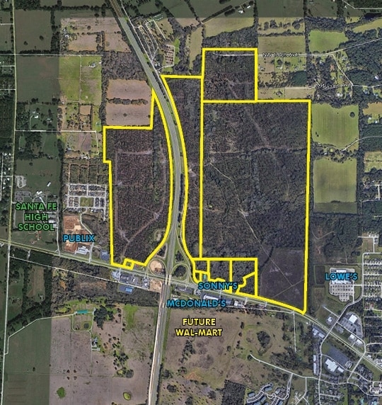
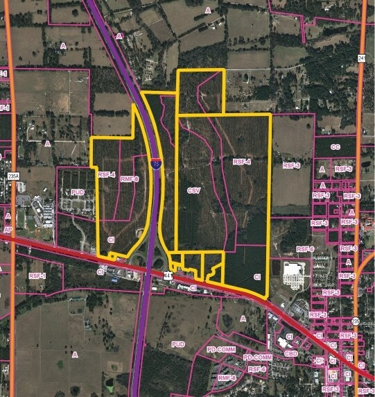
S1/2 OF E1/2 OF LOT 7 LESS R/W FOR SR-93 (LESS THAT PART LYING W OF I-75 ALSO IN SEC 09-08-18 THAT PART LYING E OF I-75 & ADJ TO & W OF SEC LINE & N OF PARCEL 3066-4) DEED APPEARS IN ERROR OR 4738/0321
03020-000-000
Alachua
Timberlandforesttreesagricultural
Florida
A
7
12001C0120D
65.12 AC
2025
Gainesville
2025
Other Market Areas
001816
DEMOGRAPHICS near 17129 Unassigned Location Re Blvd
1 Mile
3 Mile
5 Mile
2024 Total Population
1,274
9,701
14,661
2029 Population
1,352
10,278
15,532
Pop Growth 2024-2029
+ 6.12%
+ 5.95%
+ 5.94%
Average Age
41
41
42
2024 Total Households
486
3,888
5,804
HH Growth 2024-2029
+ 5.97%
+ 6.07%
+ 6.06%
Median Household Inc
$78,788
$76,807
$75,524
Avg Household Size
2.60
2.50
2.50
2024 Avg HH Vehicles
2.00
2.00
2.00
Median Home Value
$309,375
$265,232
$262,358
Median Year Built
2000
1994
1995
Nearby Places
Map Layers
Map Styles
 Street
 Aerial
- Restaurants
- Banks
- Shops
- Fitness
- Groceries
PUBLIC TRANSPORTATION
AIRPORT
Gainesville Regional
DRIVE
WALK
Distance
Gainesville Regional
33 min
18.7 mi
Freight Ports
Jacksonville Port
DRIVE
WALK
Distance
Jacksonville Port
116 min
81.5 mi
SALE & LEASE HISTORY
LISTING DATE
SALE/LEASE

Mar 30, 2017
For Sale
Nearby Properties
Address
Land Use
TOTAL SIZE
Lot Size
Zoning
Address
Land Use
TOTAL SIZE
Lot Size
Zoning
204,258 SF
23.24 AC
ILW
Address
Land Use
TOTAL SIZE
Lot Size
Zoning
1,296,224 SF
67.06 AC
A
Address
Land Use
TOTAL SIZE
Lot Size
Zoning
318,416 SF
22.90 AC
RMF-15
Address
Land Use
TOTAL SIZE
Lot Size
Zoning
99,873 SF
34 AC
A
Address
Land Use
TOTAL SIZE
Lot Size
Zoning
200,050 SF
18.60 AC
RSF-3
Address
Land Use
TOTAL SIZE
Lot Size
Zoning
76,504 SF
20 AC
RSF-3
Address
Land Use
TOTAL SIZE
Lot Size
Zoning
56,468 SF
4.25 AC
Address
Land Use
TOTAL SIZE
Lot Size
Zoning
43,646 SF
4.90 AC
ILW
Address
Land Use
TOTAL SIZE
Lot Size
Zoning
64,076 SF
2.73 AC
CI
Address
Land Use
TOTAL SIZE
Lot Size
Zoning
40,804 SF
3.94 AC
ILW
Address
Land Use
TOTAL SIZE
Lot Size
Zoning
42,695 SF
10.66 AC
CI
Address
Land Use
TOTAL SIZE
Lot Size
Zoning
125,982 SF
23.50 AC
CI
Address
Land Use
TOTAL SIZE
Lot Size
Zoning
23,683 SF
6.02 AC
ILW
Address
Land Use
TOTAL SIZE
Lot Size
Zoning
37,274 SF
6.14 AC
PUD
Address
Land Use
TOTAL SIZE
Lot Size
Zoning
132,880 SF
20 AC
IG
Address
Land Use
TOTAL SIZE
Lot Size
Zoning
38,024 SF
3.17 AC
CI
Address
Land Use
TOTAL SIZE
Lot Size
Zoning
9,113 SF
36.19 AC
A
Address
Land Use
TOTAL SIZE
Lot Size
Zoning
25,077 SF
20.38 AC
C-3
Address
Land Use
TOTAL SIZE
Lot Size
Zoning
35,745 SF
9.73 AC
GF
Address
Land Use
TOTAL SIZE
Lot Size
Zoning
47,612 SF
7.33 AC
CI
Address
Land Use
TOTAL SIZE
Lot Size
Zoning
40,173 SF
105.68 AC
GF
Address
Land Use
TOTAL SIZE
Lot Size
Zoning
25,876 SF
4.13 AC
RSF-3
Address
Land Use
TOTAL SIZE
Lot Size
Zoning
55,136 SF
11.08 AC
RSF-3
Address
Land Use
TOTAL SIZE
Lot Size
Zoning
49,655 SF
7.44 AC
CI
Address
Land Use
TOTAL SIZE
Lot Size
Zoning
47,220 SF
6.64 AC
RSF-3
Address
Land Use
TOTAL SIZE
Lot Size
Zoning
22,342 SF
4.45 AC
PUD
Address
Land Use
TOTAL SIZE
Lot Size
Zoning
3.19 AC
CI
Address
Land Use
TOTAL SIZE
Lot Size
Zoning
1,848 SF
3.69 AC
CI
Address
Land Use
TOTAL SIZE
Lot Size
Zoning
15,268 SF
2.92 AC
CI
Address
Land Use
TOTAL SIZE
Lot Size
Zoning
25,566 SF
17.76 AC
A
The World's #1 Commercial Real Estate Marketplace
Connect with us
© 2026 CoStar Group
The information above has been obtained from sources believed reliable. While we do not doubt its accuracy we have not verified it and make no guarantee, warranty or representation about it. It is your responsibility to independently confirm its accuracy and completeness. Any projections, opinions, assumptions, or estimates used are for example only and do not represent the current or future performance of the property. The value of this transaction to you depends on tax and other factors which should be evaluated by your tax, financial, and legal advisors. You and your advisors should conduct a careful, independent investigation of the property to determine to your satisfaction the suitability of the property for your needs.