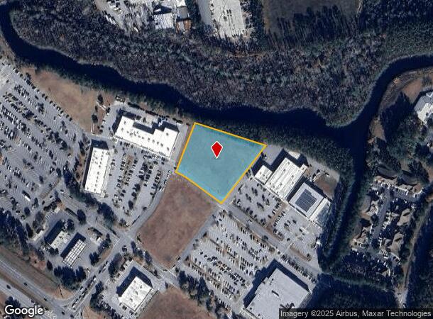
Property Record
120 Cooper Plate Rd, Hardeeville, SC 29927
NEARBY LISTINGS FOR SALE OR LEASE
Property Detail
120 Cooper Plate Rd
Hilton Head Island-Bluffton-Beaufort, SC
New River Crossing Nickel Plate Road
067-01-00-056
COUNTY (DISTRICT 06)
Commercialacreage
Jasper
A
South Carolina
45053C0415D
1.99 AC
2025
I-95 Walterboro/Hardeeville
2025
Other Market Areas
950301
DEMOGRAPHICS near 120 Cooper Plate Rd
1 Mile
3 Mile
5 Mile
2024 Total Population
3,645
20,899
43,528
2029 Population
4,385
24,786
50,488
Pop Growth 2024-2029
+ 20.30%
+ 18.60%
+ 15.99%
Average Age
51
58
50
2024 Total Households
1,644
10,253
18,635
HH Growth 2024-2029
+ 21.11%
+ 17.66%
+ 15.81%
Median Household Inc
$69,031
$71,037
$79,990
Avg Household Size
1.90
1.90
2.20
2024 Avg HH Vehicles
2.00
2.00
2.00
Median Home Value
$343,957
$342,651
$362,412
Median Year Built
2006
2005
2007
Nearby Places
- Restaurants
- Banks
- Shops
- Fitness
- Groceries
PUBLIC TRANSPORTATION
AIRPORT
Hilton Head
DRIVE
WALK
Distance
Hilton Head
29 min
19.7 mi
Savannah/Hilton Head International
DRIVE
WALK
Distance
Savannah/Hilton Head International
36 min
25.9 mi
Freight Ports
Georgia Ports - Savannah
DRIVE
WALK
Distance
Georgia Ports - Savannah
32 min
24.3 mi
SALE & LEASE HISTORY
LISTING DATE
SALE/LEASE

Jun 25, 2020
For Lease
Nearby Properties
Address
Land Use
TOTAL SIZE
Lot Size
Zoning
Address
Land Use
TOTAL SIZE
Lot Size
Zoning
2.61 AC
RC
Address
Land Use
TOTAL SIZE
Lot Size
Zoning
1,248 SF
39.20 AC
PDD
Address
Land Use
TOTAL SIZE
Lot Size
Zoning
1,632 SF
18.20 AC
PDD
Address
Land Use
TOTAL SIZE
Lot Size
Zoning
1,632 SF
2.85 AC
PDD
Address
Land Use
TOTAL SIZE
Lot Size
Zoning
1,632 SF
5.42 AC
RA
Address
Land Use
TOTAL SIZE
Lot Size
Zoning
924 SF
17.76 AC
H2
Address
Land Use
TOTAL SIZE
Lot Size
Zoning
188,132 SF
10.59 AC
Address
Land Use
TOTAL SIZE
Lot Size
Zoning
1,064 SF
29.45 AC
PDD
Address
Land Use
TOTAL SIZE
Lot Size
Zoning
26,844 SF
18.35 AC
6106
Address
Land Use
TOTAL SIZE
Lot Size
Zoning
67,941 SF
15.45 AC
Address
Land Use
TOTAL SIZE
Lot Size
Zoning
56,327 SF
50.02 AC
6616
Address
Land Use
TOTAL SIZE
Lot Size
Zoning
7,700 SF
167.61 AC
FR
Address
Land Use
TOTAL SIZE
Lot Size
Zoning
Address
Land Use
TOTAL SIZE
Lot Size
Zoning
7.22 AC
Address
Land Use
TOTAL SIZE
Lot Size
Zoning
81,625 SF
5.43 AC
Address
Land Use
TOTAL SIZE
Lot Size
Zoning
1,632 SF
172.10 AC
RA
Address
Land Use
TOTAL SIZE
Lot Size
Zoning
89,537 SF
12.29 AC
Address
Land Use
TOTAL SIZE
Lot Size
Zoning
76,410 SF
27.89 AC
6616
Address
Land Use
TOTAL SIZE
Lot Size
Zoning
65,592 SF
3.33 AC
6606
Address
Land Use
TOTAL SIZE
Lot Size
Zoning
65,544 SF
3.43 AC
Address
Land Use
TOTAL SIZE
Lot Size
Zoning
Address
Land Use
TOTAL SIZE
Lot Size
Zoning
3,296 SF
4.56 AC
PDD
Address
Land Use
TOTAL SIZE
Lot Size
Zoning
43,031 SF
5.92 AC
6606
Address
Land Use
TOTAL SIZE
Lot Size
Zoning
53,860 SF
3.49 AC
Address
Land Use
TOTAL SIZE
Lot Size
Zoning
1,680 SF
6.68 AC
PDD
Address
Land Use
TOTAL SIZE
Lot Size
Zoning
1,632 SF
18.77 AC
PDD
Address
Land Use
TOTAL SIZE
Lot Size
Zoning
17,304 SF
28.46 AC
6816
The World's #1 Commercial Real Estate Marketplace
Connect with us
© 2025 CoStar Group
The information above has been obtained from sources believed reliable. While we do not doubt its accuracy we have not verified it and make no guarantee, warranty or representation about it. It is your responsibility to independently confirm its accuracy and completeness. Any projections, opinions, assumptions, or estimates used are for example only and do not represent the current or future performance of the property. The value of this transaction to you depends on tax and other factors which should be evaluated by your tax, financial, and legal advisors. You and your advisors should conduct a careful, independent investigation of the property to determine to your satisfaction the suitability of the property for your needs.