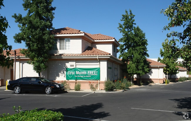
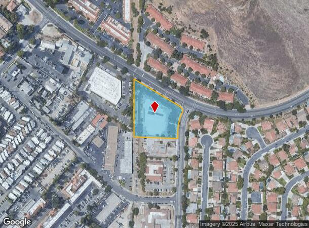
Property Record
161 Duesenberg Dr, Westlake Village, CA 91362

NEARBY LISTINGS FOR SALE OR LEASE
-
-
View all Westlake Village listings for sale on LoopNet.com
Property Detail
161 Duesenberg Dr
680-0-161-035
LOT: 1 REF: 014PM 047
Publicstorage
Ventura
X
California
06111C0987F
1
2024
1.92 AC
2025
Thousand Oaks/SE County
007100
Los Angeles
66,432 SF
Oxnard-Thousand Oaks-Ventura, CA
DEMOGRAPHICS near 161 Duesenberg Dr
1 Mile
3 Mile
5 Mile
2024 Total Population
8,983
61,894
140,847
2029 Population
8,894
61,078
138,558
Pop Growth 2024-2029
(0.99%)
(1.32%)
(1.63%)
Average Age
42
44
44
2024 Total Households
3,633
24,314
52,290
HH Growth 2024-2029
(1.07%)
(1.44%)
(1.73%)
Median Household Inc
$96,483
$119,425
$126,817
Avg Household Size
2.40
2.50
2.60
2024 Avg HH Vehicles
2.00
2.00
2.00
Median Home Value
$768,732
$936,714
$875,298
Median Year Built
1976
1977
1978
Nearby Places
Map Layers
Map Styles
 Street
 Aerial
- Restaurants
- Banks
- Shops
- Fitness
- Groceries
PUBLIC TRANSPORTATION
AIRPORT
Bob Hope
DRIVE
WALK
Distance
Bob Hope
43 min
33.0 mi
Los Angeles International
DRIVE
WALK
Distance
Los Angeles International
53 min
41.1 mi
Freight Ports
The Port of Hueneme
DRIVE
WALK
Distance
The Port of Hueneme
36 min
25.2 mi
Nearby Properties
Address
Land Use
TOTAL SIZE
Lot Size
Zoning
Address
Land Use
TOTAL SIZE
Lot Size
Zoning
38,851 SF
40.49 AC
M-1
Address
Land Use
TOTAL SIZE
Lot Size
Zoning
676,545 SF
19.76 AC
WVM1*
Address
Land Use
TOTAL SIZE
Lot Size
Zoning
239,224 SF
11.65 AC
Address
Land Use
TOTAL SIZE
Lot Size
Zoning
253,686 SF
13.69 AC
RPD2
Address
Land Use
TOTAL SIZE
Lot Size
Zoning
142,150 SF
15.35 AC
AH SP*
Address
Land Use
TOTAL SIZE
Lot Size
Zoning
233,391 SF
11.71 AC
RPD2
Address
Land Use
TOTAL SIZE
Lot Size
Zoning
384,742 SF
19.93 AC
RPD2
Address
Land Use
TOTAL SIZE
Lot Size
Zoning
736,464 SF
19.64 AC
WVM1*
Address
Land Use
TOTAL SIZE
Lot Size
Zoning
15,596 SF
3.17 AC
C2
Address
Land Use
TOTAL SIZE
Lot Size
Zoning
17,278 SF
15.46 AC
Address
Land Use
TOTAL SIZE
Lot Size
Zoning
182,756 SF
8.88 AC
RPD1
Address
Land Use
TOTAL SIZE
Lot Size
Zoning
162,078 SF
9.05 AC
R3
Address
Land Use
TOTAL SIZE
Lot Size
Zoning
10.63 AC
C4
Address
Land Use
TOTAL SIZE
Lot Size
Zoning
168,729 SF
10.21 AC
WVM1*
Address
Land Use
TOTAL SIZE
Lot Size
Zoning
2,398 SF
11.59 AC
C2
Address
Land Use
TOTAL SIZE
Lot Size
Zoning
117,172 SF
14.47 AC
C1
Address
Land Use
TOTAL SIZE
Lot Size
Zoning
177,503 SF
5.36 AC
Address
Land Use
TOTAL SIZE
Lot Size
Zoning
26,654 SF
17.84 AC
C3
Address
Land Use
TOTAL SIZE
Lot Size
Zoning
127,196 SF
10.18 AC
MULT
Address
Land Use
TOTAL SIZE
Lot Size
Zoning
116,906 SF
6.35 AC
LCA21*
Address
Land Use
TOTAL SIZE
Lot Size
Zoning
206,886 SF
12.11 AC
Address
Land Use
TOTAL SIZE
Lot Size
Zoning
201,223 SF
6.94 AC
LCA21*
Address
Land Use
TOTAL SIZE
Lot Size
Zoning
6,606 SF
5.42 AC
M1
Address
Land Use
TOTAL SIZE
Lot Size
Zoning
90,194 SF
4.12 AC
Address
Land Use
TOTAL SIZE
Lot Size
Zoning
365,098 SF
18.18 AC
WVM1*
Address
Land Use
TOTAL SIZE
Lot Size
Zoning
73,421 SF
2.66 AC
C2
Address
Land Use
TOTAL SIZE
Lot Size
Zoning
42,203 SF
16.37 AC
CHEVRON TE
Address
Land Use
TOTAL SIZE
Lot Size
Zoning
94,268 SF
0.81 AC
Address
Land Use
TOTAL SIZE
Lot Size
Zoning
138,762 SF
8.69 AC
LCA21*
Address
Land Use
TOTAL SIZE
Lot Size
Zoning
89,664 SF
5.03 AC
R-3
The World's #1 Commercial Real Estate Marketplace
Connect with us
© 2025 CoStar Group
The information above has been obtained from sources believed reliable. While we do not doubt its accuracy we have not verified it and make no guarantee, warranty or representation about it. It is your responsibility to independently confirm its accuracy and completeness. Any projections, opinions, assumptions, or estimates used are for example only and do not represent the current or future performance of the property. The value of this transaction to you depends on tax and other factors which should be evaluated by your tax, financial, and legal advisors. You and your advisors should conduct a careful, independent investigation of the property to determine to your satisfaction the suitability of the property for your needs.