Property Record
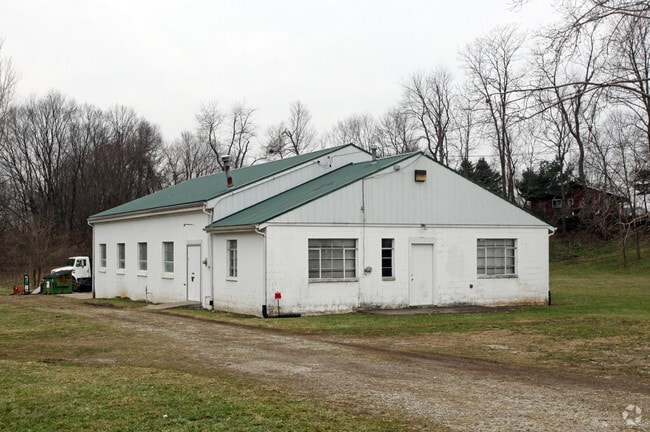
161 Forry St, Newark, OH 43055


NEARBY LISTINGS FOR SALE OR LEASE
Property Detail
161 Forry St
Columbus, OH
S 21St St
054-216900-00.000
8.064 AC R12 T2 Q4
Restaurantbuilding
Licking
X
Ohio
39089C0341H
6
2024
8.06 AC
2024
Licking County
750700
Columbus
4,824 SF
DEMOGRAPHICS near 161 Forry St
1 Mile
3 Mile
5 Mile
2024 Total Population
8,804
52,425
73,278
2029 Population
9,215
54,862
76,732
Pop Growth 2024-2029
+ 4.67%
+ 4.65%
+ 4.71%
Average Age
40
40
41
2024 Total Households
3,715
21,884
29,992
HH Growth 2024-2029
+ 4.63%
+ 4.65%
+ 4.74%
Median Household Inc
$46,114
$54,029
$58,846
Avg Household Size
2.30
2.30
2.30
2024 Avg HH Vehicles
2.00
2.00
2.00
Median Home Value
$97,125
$143,935
$160,047
Median Year Built
1952
1962
1967
Nearby Places
Map Layers
Map Styles
 Street
 Aerial
- Restaurants
- Banks
- Shops
- Fitness
- Groceries
PUBLIC TRANSPORTATION
AIRPORT
John Glenn Columbus International
DRIVE
WALK
Distance
John Glenn Columbus International
45 min
30.9 mi
Rickenbacker International
DRIVE
WALK
Distance
Rickenbacker International
53 min
39.6 mi
Nearby Properties
Address
Land Use
TOTAL SIZE
Lot Size
Zoning
Address
Land Use
TOTAL SIZE
Lot Size
Zoning
212,744 SF
19.16 AC
Address
Land Use
TOTAL SIZE
Lot Size
Zoning
54,600 SF
101.38 AC
Address
Land Use
TOTAL SIZE
Lot Size
Zoning
87,785 SF
37.26 AC
Address
Land Use
TOTAL SIZE
Lot Size
Zoning
68,326 SF
28.51 AC
Address
Land Use
TOTAL SIZE
Lot Size
Zoning
69,244 SF
38 AC
Address
Land Use
TOTAL SIZE
Lot Size
Zoning
67,824 SF
16.26 AC
Address
Land Use
TOTAL SIZE
Lot Size
Zoning
143,636 SF
7.25 AC
Address
Land Use
TOTAL SIZE
Lot Size
Zoning
3,108 SF
19.22 AC
Address
Land Use
TOTAL SIZE
Lot Size
Zoning
69,782 SF
2.41 AC
Address
Land Use
TOTAL SIZE
Lot Size
Zoning
206,532 SF
21.65 AC
Address
Land Use
TOTAL SIZE
Lot Size
Zoning
223,436 SF
19.22 AC
Address
Land Use
TOTAL SIZE
Lot Size
Zoning
118,791 SF
16.01 AC
Address
Land Use
TOTAL SIZE
Lot Size
Zoning
4,018,110 SF
19.93 AC
Address
Land Use
TOTAL SIZE
Lot Size
Zoning
19,200 SF
14.56 AC
Address
Land Use
TOTAL SIZE
Lot Size
Zoning
73,269 SF
15.64 AC
Address
Land Use
TOTAL SIZE
Lot Size
Zoning
3,552 SF
5.23 AC
Address
Land Use
TOTAL SIZE
Lot Size
Zoning
31,271 SF
20.10 AC
Address
Land Use
TOTAL SIZE
Lot Size
Zoning
94,672 SF
13.37 AC
Address
Land Use
TOTAL SIZE
Lot Size
Zoning
4,080 SF
12.84 AC
Address
Land Use
TOTAL SIZE
Lot Size
Zoning
57,280 SF
4.04 AC
Address
Land Use
TOTAL SIZE
Lot Size
Zoning
50,482 SF
13.91 AC
Address
Land Use
TOTAL SIZE
Lot Size
Zoning
33,492 SF
1.07 AC
Address
Land Use
TOTAL SIZE
Lot Size
Zoning
22,974 SF
1.64 AC
Address
Land Use
TOTAL SIZE
Lot Size
Zoning
79,454 SF
19.13 AC
Address
Land Use
TOTAL SIZE
Lot Size
Zoning
78,000 SF
25 AC
Address
Land Use
TOTAL SIZE
Lot Size
Zoning
63,635 SF
7.91 AC
Address
Land Use
TOTAL SIZE
Lot Size
Zoning
135,148 SF
14.94 AC
Address
Land Use
TOTAL SIZE
Lot Size
Zoning
65,860 SF
3.35 AC
Address
Land Use
TOTAL SIZE
Lot Size
Zoning
316,800 SF
10.74 AC
Address
Land Use
TOTAL SIZE
Lot Size
Zoning
12,434 SF
103.18 AC
The World's #1 Commercial Real Estate Marketplace
Connect with us
© 2026 CoStar Group
The information above has been obtained from sources believed reliable. While we do not doubt its accuracy we have not verified it and make no guarantee, warranty or representation about it. It is your responsibility to independently confirm its accuracy and completeness. Any projections, opinions, assumptions, or estimates used are for example only and do not represent the current or future performance of the property. The value of this transaction to you depends on tax and other factors which should be evaluated by your tax, financial, and legal advisors. You and your advisors should conduct a careful, independent investigation of the property to determine to your satisfaction the suitability of the property for your needs.