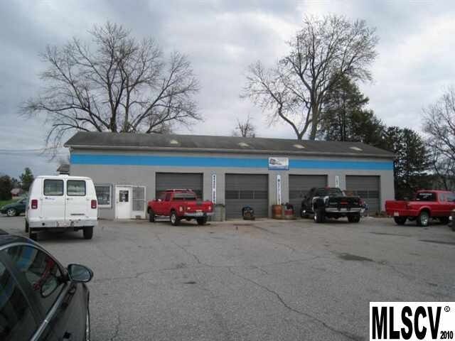
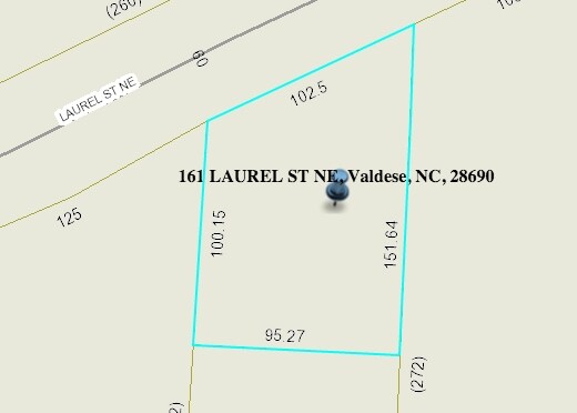
Property Record
161 Laurel St Ne, Valdese, NC 28690


Property Detail
161 Laurel St Ne
40907
161 LAUREL ST NE VALDESE, NC 28690
Realpropertynec
Burke
CENTRAL BU
North Carolina
B and X Area of moderate flood hazard, usually the area between the limits of the 100-year and 500-year floods.
0.29 AC
2025
Burke County
2025
Charlotte
020902
Hickory-Lenoir-Morganton, NC
2,400 SF
NEARBY LISTINGS FOR SALE OR LEASE
-
-
View all Valdese listings for sale on LoopNet.com
DEMOGRAPHICS near 161 Laurel St Ne
1 mile
3 mile
5 mile
2025 Total Population
3,212
10,861
22,722
2030 Population
3,258
10,918
22,859
Pop Growth 2025-2030
+ 1.43%
+ 0.52%
+ 0.60%
Average Age
45
46
45
2025 Total Households
1,373
4,547
9,452
HH Growth 2025-2030
+ 1.60%
+ 0.64%
+ 0.67%
Median Household Inc
$62,808
$61,518
$61,349
Avg Household Size
2.30
2.30
2.40
2025 Avg HH Vehicles
2.00
2.00
2.00
Median Home Value
$216,579
$223,783
$215,543
Median Year Built
1969
1972
1978
Nearby Places
Map Layers
Map Styles
 Street
 Aerial
Transit
 Traffic
 Biking
Places
Listings with unknown addresses are not visible on the map
- Restaurants
- Banks
- Shops
- Fitness
- Groceries
SALE & LEASE HISTORY
LISTING DATE
SALE/LEASE

Sep 24, 2016
For Sale
Oct 17, 2016
For Sale
May 15, 2017
For Sale
Nearby Properties
Address
Land Use
TOTAL SIZE
Lot Size
Zoning
Address
Land Use
TOTAL SIZE
Lot Size
Zoning
GENERAL BU
Address
Land Use
TOTAL SIZE
Lot Size
Zoning
GENERAL MA
Address
Land Use
TOTAL SIZE
Lot Size
Zoning
R-12 RESID
Address
Land Use
TOTAL SIZE
Lot Size
Zoning
5,868 SF
15.83 AC
GENERAL MA
Address
Land Use
TOTAL SIZE
Lot Size
Zoning
128 SF
R-12 RESID
Address
Land Use
TOTAL SIZE
Lot Size
Zoning
42,565 SF
5.10 AC
GENERAL BU
Address
Land Use
TOTAL SIZE
Lot Size
Zoning
51,742 SF
R-8 RESIDE
Address
Land Use
TOTAL SIZE
Lot Size
Zoning
14,742 SF
9.60 AC
R-8 RESIDE
Address
Land Use
TOTAL SIZE
Lot Size
Zoning
1,668 SF
R-8 RESIDE
Address
Land Use
TOTAL SIZE
Lot Size
Zoning
194,159 SF
41.19 AC
GENERAL MA
Address
Land Use
TOTAL SIZE
Lot Size
Zoning
205,525 SF
11.79 AC
GENERAL MA
Address
Land Use
TOTAL SIZE
Lot Size
Zoning
25,402 SF
R-8 RESIDE
Address
Land Use
TOTAL SIZE
Lot Size
Zoning
7,200 SF
OFFICE-INS
Address
Land Use
TOTAL SIZE
Lot Size
Zoning
14,550 SF
1.56 AC
HIGHWAY BU
Address
Land Use
TOTAL SIZE
Lot Size
Zoning
76.07 AC
GENERAL MA
Address
Land Use
TOTAL SIZE
Lot Size
Zoning
163,919 SF
16.96 AC
GENERAL MA
Address
Land Use
TOTAL SIZE
Lot Size
Zoning
10,125 SF
1.38 AC
HIGHWAY BU
Address
Land Use
TOTAL SIZE
Lot Size
Zoning
6,576 SF
6.06 AC
R-8 RESIDE
Address
Land Use
TOTAL SIZE
Lot Size
Zoning
3,071 SF
4.82 AC
R-12A RESI
Address
Land Use
TOTAL SIZE
Lot Size
Zoning
2,218 SF
6.10 AC
R-8 RESIDE
Address
Land Use
TOTAL SIZE
Lot Size
Zoning
37,974 SF
7.27 AC
GENERAL BU
Address
Land Use
TOTAL SIZE
Lot Size
Zoning
119,915 SF
26.49 AC
GENERAL MA
Address
Land Use
TOTAL SIZE
Lot Size
Zoning
56,633 SF
17.91 AC
GENERAL MA
Address
Land Use
TOTAL SIZE
Lot Size
Zoning
R-12 RESID
Address
Land Use
TOTAL SIZE
Lot Size
Zoning
13,437 SF
OFFICE-INS
Address
Land Use
TOTAL SIZE
Lot Size
Zoning
24,760 SF
R-8 RESIDE
Address
Land Use
TOTAL SIZE
Lot Size
Zoning
11,654 SF
OFFICE-INS
Address
Land Use
TOTAL SIZE
Lot Size
Zoning
87,061 SF
25.12 AC
GENERAL MA
Address
Land Use
TOTAL SIZE
Lot Size
Zoning
29,812 SF
R-12 RESID
Address
Land Use
TOTAL SIZE
Lot Size
Zoning
5,256 SF
4.13 AC
R-8 RESIDE
The World's #1 Commercial Real Estate Marketplace
Connect with us
© 2026 CoStar Group
The information above has been obtained from sources believed reliable. While we do not doubt its accuracy we have not verified it and make no guarantee, warranty or representation about it. It is your responsibility to independently confirm its accuracy and completeness. Any projections, opinions, assumptions, or estimates used are for example only and do not represent the current or future performance of the property. The value of this transaction to you depends on tax and other factors which should be evaluated by your tax, financial, and legal advisors. You and your advisors should conduct a careful, independent investigation of the property to determine to your satisfaction the suitability of the property for your needs.