Property Record
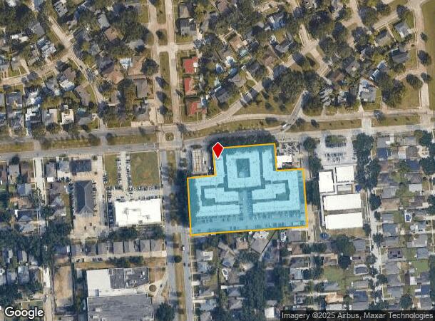
1610 Allen Toussaint Blvd, New Orleans, LA 70122

NEARBY LISTINGS FOR SALE OR LEASE
-
-
View all New Orleans listings for sale on LoopNet.com
Property Detail
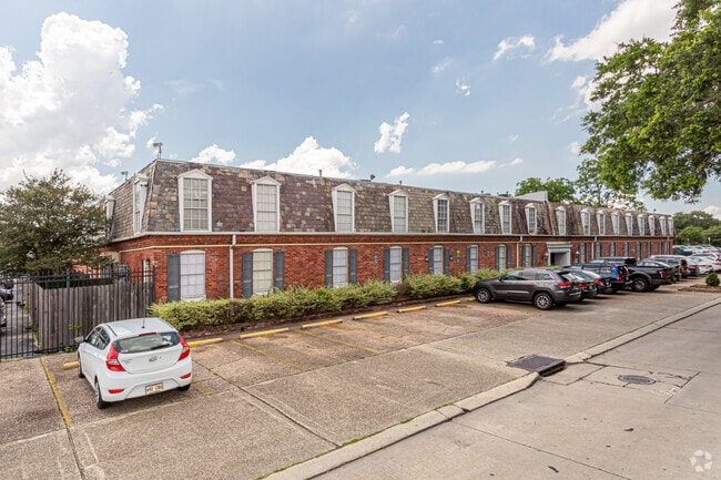
1610 Allen Toussaint Blvd
New Orleans-Metairie, LA
Vista Pk
3-7W-5-277-33
VISTA PARK SQ 17 LOT 31 H, ALLEN TOUSSAINT BL THRU PARIS AVE 67/275 X 275/VAR B. LAKE TERRACE GARDEN APTS
Apartment
Orleans
AE
Louisiana
22051C0140F
31
2025
4.33 AC
2025
Fillmore
003301
New Orleans/Metairie/Kenner
177,832 SF
DEMOGRAPHICS near 1610 Allen Toussaint Blvd
1 Mile
3 Mile
5 Mile
2024 Total Population
10,395
68,815
206,342
2029 Population
9,779
65,312
198,762
Pop Growth 2024-2029
(5.93%)
(5.09%)
(3.67%)
Average Age
39
41
41
2024 Total Households
3,744
28,574
92,741
HH Growth 2024-2029
(6.65%)
(5.37%)
(3.61%)
Median Household Inc
$60,445
$50,660
$47,287
Avg Household Size
2.40
2.30
2.10
2024 Avg HH Vehicles
1.00
1.00
1.00
Median Home Value
$331,857
$295,882
$309,026
Median Year Built
1962
1958
1957
Nearby Places
Map Layers
Map Styles
 Street
 Aerial
- Restaurants
- Banks
- Shops
- Fitness
- Groceries
PUBLIC TRANSPORTATION
COMMUTER RAIL
New Orleans Union Passenger Terminal (City of New Orleans - Amtrak, Crescent - Amtrak, Sunset Limited - Amtrak)
DRIVE
WALK
Distance
New Orleans Union Passenger Terminal (City of New Orleans - Amtrak, Crescent - Amtrak, Sunset Limited - Amtrak)
14 min
5.9 mi
AIRPORT
Louis Armstrong New Orleans International
DRIVE
WALK
Distance
Louis Armstrong New Orleans International
23 min
15.1 mi
Freight Ports
Port of New Orleans
DRIVE
WALK
Distance
Port of New Orleans
21 min
9.5 mi
Nearby Properties
Address
Land Use
TOTAL SIZE
Lot Size
Zoning
Address
Land Use
TOTAL SIZE
Lot Size
Zoning
150.60 AC
EC
Address
Land Use
TOTAL SIZE
Lot Size
Zoning
725,677 SF
54.19 AC
EC
Address
Land Use
TOTAL SIZE
Lot Size
Zoning
33.64 AC
EC
Address
Land Use
TOTAL SIZE
Lot Size
Zoning
225,284 SF
16.83 AC
S-RD
Address
Land Use
TOTAL SIZE
Lot Size
Zoning
224,374 SF
92.67 AC
HU-RD1
Address
Land Use
TOTAL SIZE
Lot Size
Zoning
7.56 AC
S-LRS1
Address
Land Use
TOTAL SIZE
Lot Size
Zoning
189,613 SF
71.45 AC
S-RD
Address
Land Use
TOTAL SIZE
Lot Size
Zoning
8,300 SF
30.83 AC
EC
Address
Land Use
TOTAL SIZE
Lot Size
Zoning
14.83 AC
EC
Address
Land Use
TOTAL SIZE
Lot Size
Zoning
484,670 SF
18.69 AC
EC
Address
Land Use
TOTAL SIZE
Lot Size
Zoning
173,008 SF
4.03 AC
S-RS
Address
Land Use
TOTAL SIZE
Lot Size
Zoning
20.49 AC
S-RS
Address
Land Use
TOTAL SIZE
Lot Size
Zoning
183.59 AC
OS-R
Address
Land Use
TOTAL SIZE
Lot Size
Zoning
Address
Land Use
TOTAL SIZE
Lot Size
Zoning
98,642 SF
7.30 AC
HU-RS
Address
Land Use
TOTAL SIZE
Lot Size
Zoning
1.14 AC
S-B2
Address
Land Use
TOTAL SIZE
Lot Size
Zoning
104,900 SF
7.37 AC
S-RS
Address
Land Use
TOTAL SIZE
Lot Size
Zoning
108,104 SF
8.98 AC
S-LRS1
Address
Land Use
TOTAL SIZE
Lot Size
Zoning
435,732 SF
29.06 AC
LI
Address
Land Use
TOTAL SIZE
Lot Size
Zoning
13,496 SF
3.01 AC
HU-RD2
Address
Land Use
TOTAL SIZE
Lot Size
Zoning
210,959 SF
6.61 AC
EC
Address
Land Use
TOTAL SIZE
Lot Size
Zoning
7.32 AC
S-RS
Address
Land Use
TOTAL SIZE
Lot Size
Zoning
3.06 AC
HU-RD1
Address
Land Use
TOTAL SIZE
Lot Size
Zoning
95,728 SF
5.01 AC
S-RS
Address
Land Use
TOTAL SIZE
Lot Size
Zoning
98,500 SF
5.54 AC
S-RS
Address
Land Use
TOTAL SIZE
Lot Size
Zoning
6.62 AC
MU-1
Address
Land Use
TOTAL SIZE
Lot Size
Zoning
24.20 AC
EC
Address
Land Use
TOTAL SIZE
Lot Size
Zoning
4.39 AC
S-RS
The World's #1 Commercial Real Estate Marketplace
Connect with us
© 2025 CoStar Group
The information above has been obtained from sources believed reliable. While we do not doubt its accuracy we have not verified it and make no guarantee, warranty or representation about it. It is your responsibility to independently confirm its accuracy and completeness. Any projections, opinions, assumptions, or estimates used are for example only and do not represent the current or future performance of the property. The value of this transaction to you depends on tax and other factors which should be evaluated by your tax, financial, and legal advisors. You and your advisors should conduct a careful, independent investigation of the property to determine to your satisfaction the suitability of the property for your needs.