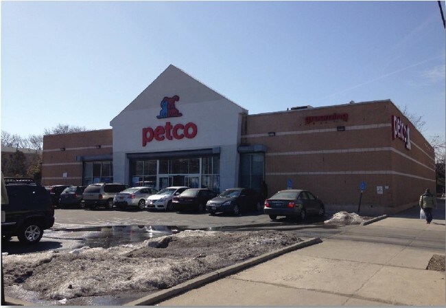
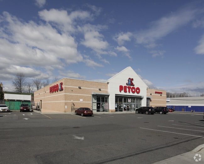
Property Record
1610 Avenue Y, Brooklyn, NY 11235
NEARBY LISTINGS FOR SALE OR LEASE
Property Detail
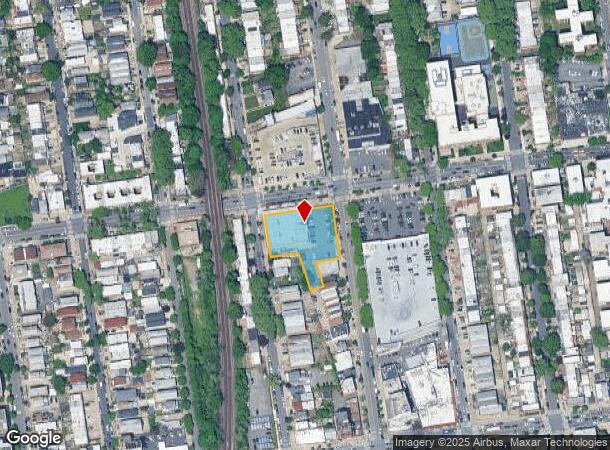
1610 Avenue Y
07437-0001
Kings
Storebuilding
New York
X
1
3604970354F
0.73 AC
2024
South Brooklyn
2025
Long Island (New York)
059000
New York-Jersey City-White Plains, NY-NJ
13,530 SF
DEMOGRAPHICS near 1610 Avenue Y
1 Mile
3 Mile
5 Mile
2024 Total Population
121,670
586,321
1,278,829
2029 Population
113,463
547,085
1,186,086
Pop Growth 2024-2029
(6.75%)
(6.69%)
(7.25%)
Average Age
43
42
40
2024 Total Households
46,109
208,430
442,609
HH Growth 2024-2029
(7.01%)
(7.03%)
(7.55%)
Median Household Inc
$61,850
$62,258
$65,113
Avg Household Size
2.50
2.70
2.80
2024 Avg HH Vehicles
1.00
1.00
1.00
Median Home Value
$736,869
$755,902
$775,181
Median Year Built
1951
1949
1948
Nearby Places
- Restaurants
- Banks
- Shops
- Fitness
- Groceries
PUBLIC TRANSPORTATION
TRANSIT/SUBWAY
Sheepshead Bay (B - New York MTA Subway (The Subway), Q - New York MTA Subway (The Subway))
DRIVE
WALK
Distance
Sheepshead Bay (B - New York MTA Subway (The Subway), Q - New York MTA Subway (The Subway))
2 min
7 min
0.4 mi
Neck Road (Q - New York MTA Subway (The Subway))
DRIVE
WALK
Distance
Neck Road (Q - New York MTA Subway (The Subway))
2 min
8 min
0.4 mi
Avenue U (Q Line) (Q - New York MTA Subway (The Subway))
DRIVE
WALK
Distance
Avenue U (Q Line) (Q - New York MTA Subway (The Subway))
2 min
13 min
0.7 mi
COMMUTER RAIL
East New York Station (Far Rockaway Branch - Long Island Rail Road, Long Beach Branch - Long Island Rail Road, West Hempstead Branch - Long Island Rail Road)
DRIVE
WALK
Distance
East New York Station (Far Rockaway Branch - Long Island Rail Road, Long Beach Branch - Long Island Rail Road, West Hempstead Branch - Long Island Rail Road)
14 min
7.4 mi
Nostrand Avenue Station (Far Rockaway Branch - Long Island Rail Road, Hempstead Branch - Long Island Rail Road, Long Beach Branch - Long Island Rail Road, West Hempstead Branch - Long Island Rail Road)
DRIVE
WALK
Distance
Nostrand Avenue Station (Far Rockaway Branch - Long Island Rail Road, Hempstead Branch - Long Island Rail Road, Long Beach Branch - Long Island Rail Road, West Hempstead Branch - Long Island Rail Road)
19 min
7.7 mi
AIRPORT
John F Kennedy International
DRIVE
WALK
Distance
John F Kennedy International
22 min
14.7 mi
LaGuardia
DRIVE
WALK
Distance
LaGuardia
33 min
21.4 mi
Newark Liberty International
DRIVE
WALK
Distance
Newark Liberty International
39 min
24.5 mi
Freight Ports
NY - Red Hook Container Terminal
DRIVE
WALK
Distance
NY - Red Hook Container Terminal
16 min
8.0 mi
Nearby Properties
Address
Land Use
TOTAL SIZE
Lot Size
Zoning
Address
Land Use
TOTAL SIZE
Lot Size
Zoning
100 SF
1,207.35 AC
M1-1
Address
Land Use
TOTAL SIZE
Lot Size
Zoning
1,281,577 SF
20.78 AC
M3-1
Address
Land Use
TOTAL SIZE
Lot Size
Zoning
1,078,317 SF
10.45 AC
R4
Address
Land Use
TOTAL SIZE
Lot Size
Zoning
10,250 SF
773.50 AC
PARK
Address
Land Use
TOTAL SIZE
Lot Size
Zoning
965,600 SF
6.65 AC
R5
Address
Land Use
TOTAL SIZE
Lot Size
Zoning
1,073,920 SF
16.53 AC
R6
Address
Land Use
TOTAL SIZE
Lot Size
Zoning
54.78 AC
PARK
Address
Land Use
TOTAL SIZE
Lot Size
Zoning
785,450 SF
14.22 AC
R6
Address
Land Use
TOTAL SIZE
Lot Size
Zoning
353,600 SF
55.79 AC
R3-1
Address
Land Use
TOTAL SIZE
Lot Size
Zoning
12,252,000 SF
190 AC
PARK
Address
Land Use
TOTAL SIZE
Lot Size
Zoning
241,735 SF
1.99 AC
C8-4
Address
Land Use
TOTAL SIZE
Lot Size
Zoning
301,400 SF
22.27 AC
M3-1
Address
Land Use
TOTAL SIZE
Lot Size
Zoning
139,557 SF
11.47 AC
M1-1
Address
Land Use
TOTAL SIZE
Lot Size
Zoning
275,163 SF
9.69 AC
R3-1
Address
Land Use
TOTAL SIZE
Lot Size
Zoning
846,056 SF
20.71 AC
R5
Address
Land Use
TOTAL SIZE
Lot Size
Zoning
59,063 SF
21.56 AC
PARK
Address
Land Use
TOTAL SIZE
Lot Size
Zoning
209,346 SF
18.29 AC
PARK
Address
Land Use
TOTAL SIZE
Lot Size
Zoning
702,770 SF
4.47 AC
R6
Address
Land Use
TOTAL SIZE
Lot Size
Zoning
292,528 SF
1.05 AC
R6
Address
Land Use
TOTAL SIZE
Lot Size
Zoning
356,000 SF
8.19 AC
R5
Address
Land Use
TOTAL SIZE
Lot Size
Zoning
351,762 SF
1.65 AC
R7A
Address
Land Use
TOTAL SIZE
Lot Size
Zoning
208,015 SF
1.52 AC
R7X
Address
Land Use
TOTAL SIZE
Lot Size
Zoning
221,704 SF
0.83 AC
R5B
Address
Land Use
TOTAL SIZE
Lot Size
Zoning
128,170 SF
0.87 AC
R7A
Address
Land Use
TOTAL SIZE
Lot Size
Zoning
470,000 SF
3.40 AC
R6
Address
Land Use
TOTAL SIZE
Lot Size
Zoning
105,328 SF
0.11 AC
M1-6
Address
Land Use
TOTAL SIZE
Lot Size
Zoning
521,976 SF
13.59 AC
R5
Address
Land Use
TOTAL SIZE
Lot Size
Zoning
2,000 SF
73.29 AC
PARK
Address
Land Use
TOTAL SIZE
Lot Size
Zoning
60,288 SF
0.76 AC
R5
Address
Land Use
TOTAL SIZE
Lot Size
Zoning
305,046 SF
8.76 AC
R6
The World's #1 Commercial Real Estate Marketplace
Connect with us
© 2025 CoStar Group
The information above has been obtained from sources believed reliable. While we do not doubt its accuracy we have not verified it and make no guarantee, warranty or representation about it. It is your responsibility to independently confirm its accuracy and completeness. Any projections, opinions, assumptions, or estimates used are for example only and do not represent the current or future performance of the property. The value of this transaction to you depends on tax and other factors which should be evaluated by your tax, financial, and legal advisors. You and your advisors should conduct a careful, independent investigation of the property to determine to your satisfaction the suitability of the property for your needs.