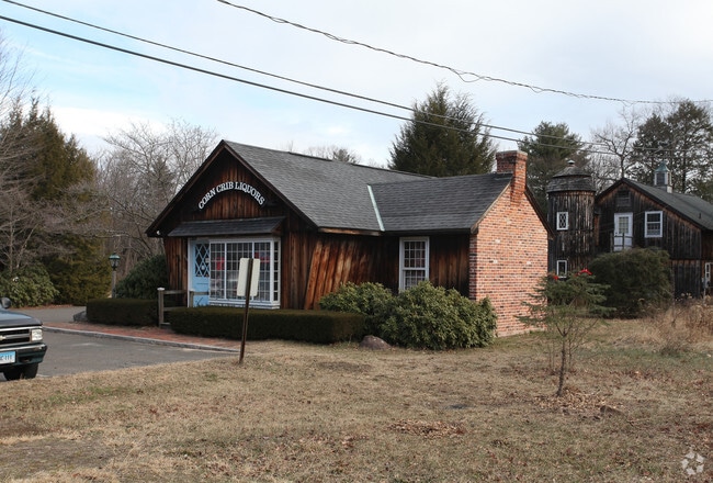
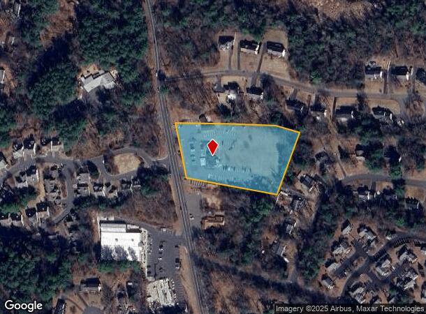
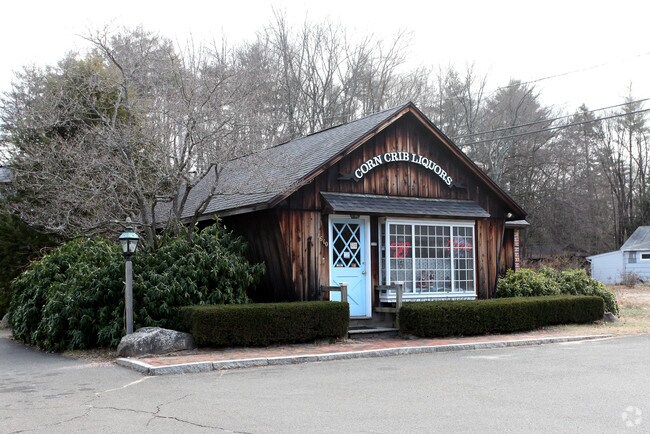
Property Record
1610 Hopmeadow St, Simsbury, CT 06070
NEARBY LISTINGS FOR SALE OR LEASE
Property Detail
1610 Hopmeadow St
SIMS-000002H-000402-000007
Hartford
Commercialnec
Connecticut
X
7
09003C0191F
2.63 AC
2025
Simsbury
2025
Hartford
466201
Hartford-West Hartford-East Hartford, CT
DEMOGRAPHICS near 1610 Hopmeadow St
1 Mile
3 Mile
5 Mile
2024 Total Population
2,455
16,712
31,937
2029 Population
2,430
16,646
31,803
Pop Growth 2024-2029
(1.02%)
(0.39%)
(0.42%)
Average Age
43
42
43
2024 Total Households
1,062
6,697
12,723
HH Growth 2024-2029
(1.04%)
(0.45%)
(0.49%)
Median Household Inc
$106,250
$119,894
$122,021
Avg Household Size
2.30
2.40
2.50
2024 Avg HH Vehicles
2.00
2.00
2.00
Median Home Value
$336,188
$337,724
$341,414
Median Year Built
1975
1971
1973
Nearby Places
Map Layers
Map Styles
 Street
 Aerial
- Restaurants
- Banks
- Shops
- Fitness
- Groceries
PUBLIC TRANSPORTATION
AIRPORT
Bradley International
DRIVE
WALK
Distance
Bradley International
25 min
8.8 mi
Freight Ports
Port of New Haven
DRIVE
WALK
Distance
Port of New Haven
67 min
48.1 mi
Nearby Properties
Address
Land Use
TOTAL SIZE
Lot Size
Zoning
Address
Land Use
TOTAL SIZE
Lot Size
Zoning
9,882 SF
181.60 AC
R-40
Address
Land Use
TOTAL SIZE
Lot Size
Zoning
139,125 SF
35 AC
R-15
Address
Land Use
TOTAL SIZE
Lot Size
Zoning
10.26 AC
PAD
Address
Land Use
TOTAL SIZE
Lot Size
Zoning
1,517 SF
45.69 AC
CC
Address
Land Use
TOTAL SIZE
Lot Size
Zoning
27.95 AC
CC
Address
Land Use
TOTAL SIZE
Lot Size
Zoning
89,800 SF
20.20 AC
R-40
Address
Land Use
TOTAL SIZE
Lot Size
Zoning
34.66 AC
T1
Address
Land Use
TOTAL SIZE
Lot Size
Zoning
1,576 SF
9.52 AC
T1
Address
Land Use
TOTAL SIZE
Lot Size
Zoning
26,941 SF
3.58 AC
SCZ
Address
Land Use
TOTAL SIZE
Lot Size
Zoning
49,484 SF
14 AC
R-15
Address
Land Use
TOTAL SIZE
Lot Size
Zoning
37,178 SF
4.40 AC
R-25
Address
Land Use
TOTAL SIZE
Lot Size
Zoning
70,317 SF
17.08 AC
I-1
Address
Land Use
TOTAL SIZE
Lot Size
Zoning
49,808 SF
7.19 AC
B-2
Address
Land Use
TOTAL SIZE
Lot Size
Zoning
1,225 SF
0.92 AC
R-40
Address
Land Use
TOTAL SIZE
Lot Size
Zoning
16 AC
RD
Address
Land Use
TOTAL SIZE
Lot Size
Zoning
235.81 AC
I-1
Address
Land Use
TOTAL SIZE
Lot Size
Zoning
13.65 AC
R-40
Address
Land Use
TOTAL SIZE
Lot Size
Zoning
49.92 AC
Address
Land Use
TOTAL SIZE
Lot Size
Zoning
49.92 AC
Address
Land Use
TOTAL SIZE
Lot Size
Zoning
13,380 SF
4.04 AC
SCZ
Address
Land Use
TOTAL SIZE
Lot Size
Zoning
13,275 SF
5.92 AC
I-2
Address
Land Use
TOTAL SIZE
Lot Size
Zoning
13.05 AC
C2
Address
Land Use
TOTAL SIZE
Lot Size
Zoning
5.32 AC
ED
Address
Land Use
TOTAL SIZE
Lot Size
Zoning
14.38 AC
CC
Address
Land Use
TOTAL SIZE
Lot Size
Zoning
43,832 SF
3.50 AC
SCZ
Address
Land Use
TOTAL SIZE
Lot Size
Zoning
52,458 SF
2.15 AC
PAD
Address
Land Use
TOTAL SIZE
Lot Size
Zoning
5.96 AC
CO
Address
Land Use
TOTAL SIZE
Lot Size
Zoning
71,092 SF
6.23 AC
T1
Address
Land Use
TOTAL SIZE
Lot Size
Zoning
7.40 AC
CE
Address
Land Use
TOTAL SIZE
Lot Size
Zoning
2.17 AC
SCZ
The World's #1 Commercial Real Estate Marketplace
Connect with us
© 2025 CoStar Group
The information above has been obtained from sources believed reliable. While we do not doubt its accuracy we have not verified it and make no guarantee, warranty or representation about it. It is your responsibility to independently confirm its accuracy and completeness. Any projections, opinions, assumptions, or estimates used are for example only and do not represent the current or future performance of the property. The value of this transaction to you depends on tax and other factors which should be evaluated by your tax, financial, and legal advisors. You and your advisors should conduct a careful, independent investigation of the property to determine to your satisfaction the suitability of the property for your needs.