Property Record
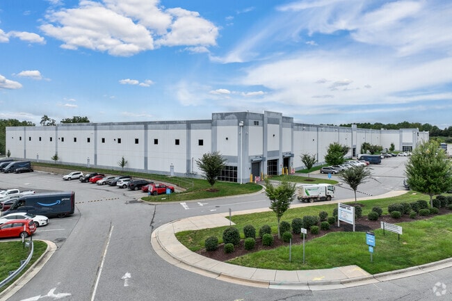
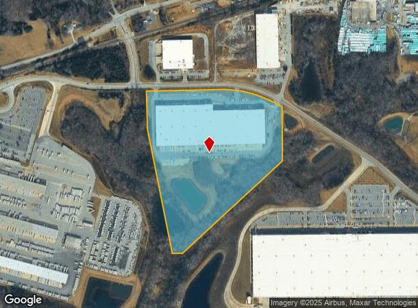
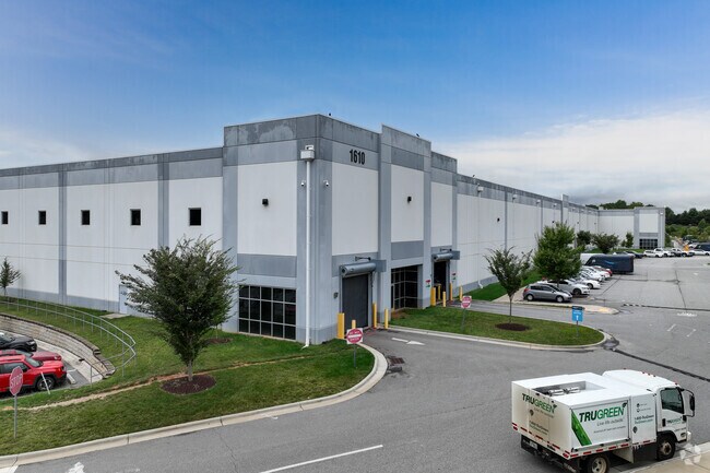
1610 Old Greensboro Rd, Kernersville, NC 27284

NEARBY LISTINGS FOR SALE OR LEASE
Property Detail
1610 Old Greensboro Rd
Greensboro-High Point, NC
Triad Bus Park Ph 1
0168911
TRIAD BUSNIESS PARK LO:3 PH:2
Industrialgeneral
Guilford
X
North Carolina
3710689500K
3
2024
30.53 AC
2025
Airport/W Guilford County
016201
Greensboro/Winston-Salem
350,268 SF
DEMOGRAPHICS near 1610 Old Greensboro Rd
1 Mile
3 Mile
5 Mile
2024 Total Population
728
17,121
57,193
2029 Population
755
17,627
59,015
Pop Growth 2024-2029
+ 3.71%
+ 2.96%
+ 3.19%
Average Age
40
42
42
2024 Total Households
294
7,580
23,331
HH Growth 2024-2029
+ 3.74%
+ 3.10%
+ 3.30%
Median Household Inc
$78,009
$59,307
$78,294
Avg Household Size
2.50
2.20
2.40
2024 Avg HH Vehicles
2.00
2.00
2.00
Median Home Value
$267,708
$228,826
$261,422
Median Year Built
2008
1991
1994
Nearby Places
Map Layers
Map Styles
 Street
 Aerial
- Restaurants
- Banks
- Shops
- Fitness
- Groceries
PUBLIC TRANSPORTATION
AIRPORT
Piedmont Triad International
DRIVE
WALK
Distance
Piedmont Triad International
21 min
10.2 mi
Freight Ports
Virginia Port Authority - Richmond
DRIVE
WALK
Distance
Virginia Port Authority - Richmond
247 min
213.9 mi
SALE & LEASE HISTORY
LISTING DATE
SALE/LEASE

Sep 25, 2016
For Lease
Nearby Properties
Address
Land Use
TOTAL SIZE
Lot Size
Zoning
Address
Land Use
TOTAL SIZE
Lot Size
Zoning
179,681 SF
38.53 AC
MBP
Address
Land Use
TOTAL SIZE
Lot Size
Zoning
274,486 SF
30.31 AC
MBP
Address
Land Use
TOTAL SIZE
Lot Size
Zoning
1,001,670 SF
94.34 AC
BI
Address
Land Use
TOTAL SIZE
Lot Size
Zoning
1,057,283 SF
104.31 AC
PDP
Address
Land Use
TOTAL SIZE
Lot Size
Zoning
667,440 SF
53.44 AC
BI
Address
Land Use
TOTAL SIZE
Lot Size
Zoning
122,848 SF
22.70 AC
RM18-S
Address
Land Use
TOTAL SIZE
Lot Size
Zoning
777,963 SF
133.64 AC
BI
Address
Land Use
TOTAL SIZE
Lot Size
Zoning
342,765 SF
20.98 AC
PUD
Address
Land Use
TOTAL SIZE
Lot Size
Zoning
428,867 SF
76.65 AC
LI
Address
Land Use
TOTAL SIZE
Lot Size
Zoning
254,290 SF
21.12 AC
RM-12
Address
Land Use
TOTAL SIZE
Lot Size
Zoning
341,000 SF
29.55 AC
LI
Address
Land Use
TOTAL SIZE
Lot Size
Zoning
129,895 SF
30.33 AC
RM18
Address
Land Use
TOTAL SIZE
Lot Size
Zoning
275,040 SF
28 AC
BI
Address
Land Use
TOTAL SIZE
Lot Size
Zoning
87,741 SF
15.44 AC
RM18
Address
Land Use
TOTAL SIZE
Lot Size
Zoning
39,959 SF
11.29 AC
GB-S
Address
Land Use
TOTAL SIZE
Lot Size
Zoning
258,154 SF
39.55 AC
GI
Address
Land Use
TOTAL SIZE
Lot Size
Zoning
244,562 SF
29.92 AC
BI
Address
Land Use
TOTAL SIZE
Lot Size
Zoning
277,250 SF
30.15 AC
GI
Address
Land Use
TOTAL SIZE
Lot Size
Zoning
109,169 SF
40.18 AC
RS30
Address
Land Use
TOTAL SIZE
Lot Size
Zoning
292,513 SF
23.84 AC
HI
Address
Land Use
TOTAL SIZE
Lot Size
Zoning
74,608 SF
8.68 AC
MBP
Address
Land Use
TOTAL SIZE
Lot Size
Zoning
160,179 SF
23.75 AC
LI-C,RS20
Address
Land Use
TOTAL SIZE
Lot Size
Zoning
603,494 SF
48.87 AC
LI
Address
Land Use
TOTAL SIZE
Lot Size
Zoning
62,688 SF
69.72 AC
HB
Address
Land Use
TOTAL SIZE
Lot Size
Zoning
43,286 SF
3.77 AC
RMU-S
Address
Land Use
TOTAL SIZE
Lot Size
Zoning
203,069 SF
71.34 AC
GI
Address
Land Use
TOTAL SIZE
Lot Size
Zoning
195,056 SF
9.64 AC
LI
Address
Land Use
TOTAL SIZE
Lot Size
Zoning
290,328 SF
24.55 AC
LI
Address
Land Use
TOTAL SIZE
Lot Size
Zoning
28,272 SF
2.26 AC
HB-S
The World's #1 Commercial Real Estate Marketplace
Connect with us
© 2026 CoStar Group
The information above has been obtained from sources believed reliable. While we do not doubt its accuracy we have not verified it and make no guarantee, warranty or representation about it. It is your responsibility to independently confirm its accuracy and completeness. Any projections, opinions, assumptions, or estimates used are for example only and do not represent the current or future performance of the property. The value of this transaction to you depends on tax and other factors which should be evaluated by your tax, financial, and legal advisors. You and your advisors should conduct a careful, independent investigation of the property to determine to your satisfaction the suitability of the property for your needs.