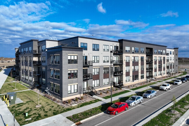
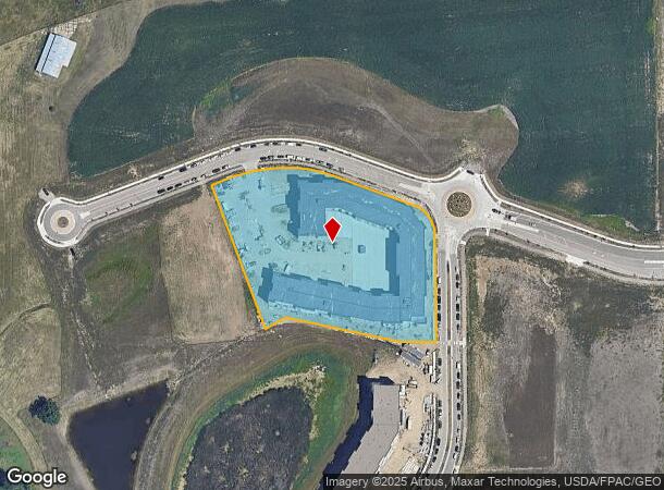
Property Record
16101 99Th Pl N, Maple Grove, MN 55369

NEARBY LISTINGS FOR SALE OR LEASE
-
-
View all Maple Grove listings for sale on LoopNet.com
Property Detail
16101 99Th Pl N
Minneapolis/St Paul
Minnesota Health Village 2Nd Addn
Minneapolis-St. Paul-Bloomington, MN-WI
LOT 001 BLOCK 001 A MINNESOTA HEALTH VILLAGE 2ND ADDN IRREGULAR
08-119-22-11-0003
Hennepin
Apartment
Minnesota
2024
1
2024
4.33 AC
026708
Maple Grove
DEMOGRAPHICS near 16101 99Th Pl N
1 Mile
3 Mile
5 Mile
2024 Total Population
3,095
33,954
85,591
2029 Population
3,114
33,479
84,559
Pop Growth 2024-2029
+ 0.61%
(1.40%)
(1.21%)
Average Age
41
40
40
2024 Total Households
1,214
12,471
31,985
HH Growth 2024-2029
+ 0.49%
(1.60%)
(1.39%)
Median Household Inc
$80,033
$124,429
$123,752
Avg Household Size
2.40
2.70
2.60
2024 Avg HH Vehicles
2.00
2.00
2.00
Median Home Value
$339,169
$379,157
$384,300
Median Year Built
1996
1993
1993
Nearby Places
Map Layers
Map Styles
 Street
 Aerial
- Restaurants
- Banks
- Shops
- Fitness
- Groceries
PUBLIC TRANSPORTATION
AIRPORT
Minneapolis-St Paul International/Wold-Chamberlain
DRIVE
WALK
Distance
Minneapolis-St Paul International/Wold-Chamberlain
44 min
32.0 mi
Freight Ports
Port Milwaukee
DRIVE
WALK
Distance
Port Milwaukee
396 min
357.1 mi
Nearby Properties
Address
Land Use
TOTAL SIZE
Lot Size
Zoning
Address
Land Use
TOTAL SIZE
Lot Size
Zoning
68.12 AC
Address
Land Use
TOTAL SIZE
Lot Size
Zoning
42.21 AC
Address
Land Use
TOTAL SIZE
Lot Size
Zoning
297,060 SF
19.17 AC
Address
Land Use
TOTAL SIZE
Lot Size
Zoning
25.06 AC
Address
Land Use
TOTAL SIZE
Lot Size
Zoning
Address
Land Use
TOTAL SIZE
Lot Size
Zoning
Address
Land Use
TOTAL SIZE
Lot Size
Zoning
Address
Land Use
TOTAL SIZE
Lot Size
Zoning
228,208 SF
24.92 AC
Address
Land Use
TOTAL SIZE
Lot Size
Zoning
10.44 AC
Address
Land Use
TOTAL SIZE
Lot Size
Zoning
132,200 SF
28.23 AC
Address
Land Use
TOTAL SIZE
Lot Size
Zoning
17.09 AC
Address
Land Use
TOTAL SIZE
Lot Size
Zoning
Address
Land Use
TOTAL SIZE
Lot Size
Zoning
Address
Land Use
TOTAL SIZE
Lot Size
Zoning
20.09 AC
Address
Land Use
TOTAL SIZE
Lot Size
Zoning
Address
Land Use
TOTAL SIZE
Lot Size
Zoning
218,144 SF
3.71 AC
Address
Land Use
TOTAL SIZE
Lot Size
Zoning
11.61 AC
Address
Land Use
TOTAL SIZE
Lot Size
Zoning
10.26 AC
Address
Land Use
TOTAL SIZE
Lot Size
Zoning
219,980 SF
18.09 AC
Address
Land Use
TOTAL SIZE
Lot Size
Zoning
Address
Land Use
TOTAL SIZE
Lot Size
Zoning
168,961 SF
15.61 AC
Address
Land Use
TOTAL SIZE
Lot Size
Zoning
178,023 SF
14.24 AC
Address
Land Use
TOTAL SIZE
Lot Size
Zoning
144,927 SF
28.23 AC
Address
Land Use
TOTAL SIZE
Lot Size
Zoning
Address
Land Use
TOTAL SIZE
Lot Size
Zoning
160,680 SF
14.17 AC
Address
Land Use
TOTAL SIZE
Lot Size
Zoning
Address
Land Use
TOTAL SIZE
Lot Size
Zoning
42,498 SF
2.94 AC
Address
Land Use
TOTAL SIZE
Lot Size
Zoning
2,170 SF
14.43 AC
Address
Land Use
TOTAL SIZE
Lot Size
Zoning
1,848 SF
13.94 AC
The World's #1 Commercial Real Estate Marketplace
Connect with us
© 2025 CoStar Group
The information above has been obtained from sources believed reliable. While we do not doubt its accuracy we have not verified it and make no guarantee, warranty or representation about it. It is your responsibility to independently confirm its accuracy and completeness. Any projections, opinions, assumptions, or estimates used are for example only and do not represent the current or future performance of the property. The value of this transaction to you depends on tax and other factors which should be evaluated by your tax, financial, and legal advisors. You and your advisors should conduct a careful, independent investigation of the property to determine to your satisfaction the suitability of the property for your needs.