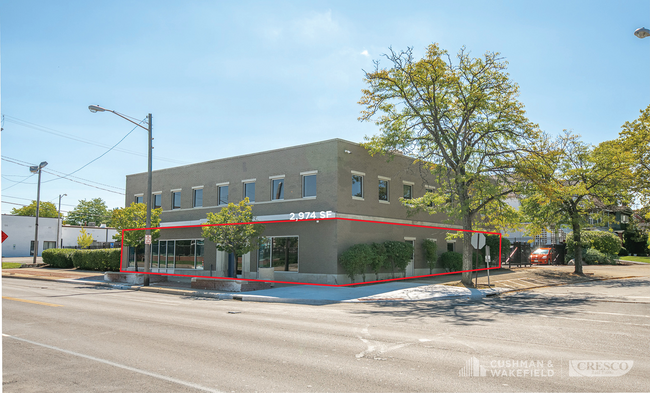
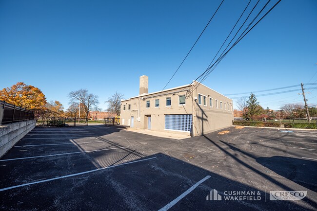
Property Record
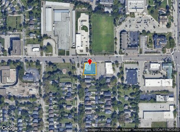
16104 Chagrin Blvd, Cleveland, OH 44120
Current Lease Availabilities
NEARBY LISTINGS FOR SALE OR LEASE
Property Detail
16104 Chagrin Blvd
735-25-073
City Of Shaker Heights
Officebuilding
2017 S/R VOL 384 PG 27 OL 52 S/L PCL A FF 110.28 D 120.96 AC 0.331
X
Cuyahoga
39035C0204E
Ohio
2024
0.33 AC
2024
East
183402
Cleveland
8,652 SF
Cleveland-Elyria, OH
DEMOGRAPHICS near 16104 Chagrin Blvd
1 Mile
3 Mile
5 Mile
2024 Total Population
20,851
129,875
321,795
2029 Population
20,241
126,800
315,600
Pop Growth 2024-2029
(2.93%)
(2.37%)
(1.93%)
Average Age
40
41
40
2024 Total Households
8,880
57,103
139,330
HH Growth 2024-2029
(3.10%)
(2.58%)
(2.03%)
Median Household Inc
$51,890
$49,403
$44,795
Avg Household Size
2.30
2.20
2.20
2024 Avg HH Vehicles
1.00
1.00
1.00
Median Home Value
$134,881
$127,815
$113,345
Median Year Built
1947
1948
1950
Nearby Places
Map Layers
Map Styles
 Street
 Aerial
- Restaurants
- Banks
- Shops
- Fitness
- Groceries
PUBLIC TRANSPORTATION
TRANSIT/SUBWAY
Lee (Blue Line) (Blue Line - Greater Cleveland Regional Transit Authority Rapid Transit (The Rapid))
DRIVE
WALK
Distance
Lee (Blue Line) (Blue Line - Greater Cleveland Regional Transit Authority Rapid Transit (The Rapid))
2 min
7 min
0.4 mi
Ashby (Blue Line - Greater Cleveland Regional Transit Authority Rapid Transit (The Rapid))
DRIVE
WALK
Distance
Ashby (Blue Line - Greater Cleveland Regional Transit Authority Rapid Transit (The Rapid))
2 min
10 min
0.5 mi
Avalon (Blue Line - Greater Cleveland Regional Transit Authority Rapid Transit (The Rapid))
DRIVE
WALK
Distance
Avalon (Blue Line - Greater Cleveland Regional Transit Authority Rapid Transit (The Rapid))
2 min
13 min
0.6 mi
Onaway (Blue Line - Greater Cleveland Regional Transit Authority Rapid Transit (The Rapid))
DRIVE
WALK
Distance
Onaway (Blue Line - Greater Cleveland Regional Transit Authority Rapid Transit (The Rapid))
3 min
16 min
0.8 mi
Kenmore (Blue Line - Greater Cleveland Regional Transit Authority Rapid Transit (The Rapid))
DRIVE
WALK
Distance
Kenmore (Blue Line - Greater Cleveland Regional Transit Authority Rapid Transit (The Rapid))
3 min
18 min
0.9 mi
COMMUTER RAIL
DRIVE
WALK
Distance
21 min
8.6 mi
DRIVE
WALK
Distance
19 min
8.7 mi
AIRPORT
Cleveland-Hopkins International
DRIVE
WALK
Distance
Cleveland-Hopkins International
32 min
18.4 mi
Nearby Properties
Address
Land Use
TOTAL SIZE
Lot Size
Zoning
Address
Land Use
TOTAL SIZE
Lot Size
Zoning
53.85 AC
2F
Address
Land Use
TOTAL SIZE
Lot Size
Zoning
1,066,853 SF
42.18 AC
U-5
Address
Land Use
TOTAL SIZE
Lot Size
Zoning
230,820 SF
41.47 AC
UI
Address
Land Use
TOTAL SIZE
Lot Size
Zoning
475,904 SF
8.04 AC
U-7A
Address
Land Use
TOTAL SIZE
Lot Size
Zoning
68.97 AC
C-1
Address
Land Use
TOTAL SIZE
Lot Size
Zoning
682,144 SF
99.58 AC
C-2
Address
Land Use
TOTAL SIZE
Lot Size
Zoning
233,767 SF
36.30 AC
U-1A1
Address
Land Use
TOTAL SIZE
Lot Size
Zoning
440,004 SF
4.25 AC
S2
Address
Land Use
TOTAL SIZE
Lot Size
Zoning
333,582 SF
3.67 AC
U-1A1
Address
Land Use
TOTAL SIZE
Lot Size
Zoning
413,626 SF
21.95 AC
S2
Address
Land Use
TOTAL SIZE
Lot Size
Zoning
143,512 SF
16 AC
Address
Land Use
TOTAL SIZE
Lot Size
Zoning
4,414 SF
112.92 AC
U-10
Address
Land Use
TOTAL SIZE
Lot Size
Zoning
18,898 SF
3.57 AC
U-3
Address
Land Use
TOTAL SIZE
Lot Size
Zoning
221,406 SF
12.05 AC
2F
Address
Land Use
TOTAL SIZE
Lot Size
Zoning
131,846 SF
5.94 AC
U-9
Address
Land Use
TOTAL SIZE
Lot Size
Zoning
249,712 SF
22.69 AC
I
Address
Land Use
TOTAL SIZE
Lot Size
Zoning
65,783 SF
2.43 AC
MF3+
Address
Land Use
TOTAL SIZE
Lot Size
Zoning
105,215 SF
5.42 AC
PF
Address
Land Use
TOTAL SIZE
Lot Size
Zoning
110,000 SF
0.85 AC
Address
Land Use
TOTAL SIZE
Lot Size
Zoning
178,654 SF
2.69 AC
Address
Land Use
TOTAL SIZE
Lot Size
Zoning
256,546 SF
25.35 AC
U-1
Address
Land Use
TOTAL SIZE
Lot Size
Zoning
153,560 SF
32.47 AC
I
Address
Land Use
TOTAL SIZE
Lot Size
Zoning
155,896 SF
16.38 AC
Address
Land Use
TOTAL SIZE
Lot Size
Zoning
24,400 SF
3.87 AC
CM
Address
Land Use
TOTAL SIZE
Lot Size
Zoning
87,403 SF
8.33 AC
2F
Address
Land Use
TOTAL SIZE
Lot Size
Zoning
164,109 SF
8.89 AC
U-1A1
Address
Land Use
TOTAL SIZE
Lot Size
Zoning
106,341 SF
30.48 AC
MF-1
Address
Land Use
TOTAL SIZE
Lot Size
Zoning
191,322 SF
23.60 AC
1F
Address
Land Use
TOTAL SIZE
Lot Size
Zoning
15,154 SF
9.24 AC
SI
Address
Land Use
TOTAL SIZE
Lot Size
Zoning
134,230 SF
7.84 AC
MF3+
The World's #1 Commercial Real Estate Marketplace
Connect with us
© 2025 CoStar Group
The information above has been obtained from sources believed reliable. While we do not doubt its accuracy we have not verified it and make no guarantee, warranty or representation about it. It is your responsibility to independently confirm its accuracy and completeness. Any projections, opinions, assumptions, or estimates used are for example only and do not represent the current or future performance of the property. The value of this transaction to you depends on tax and other factors which should be evaluated by your tax, financial, and legal advisors. You and your advisors should conduct a careful, independent investigation of the property to determine to your satisfaction the suitability of the property for your needs.