Property Record
16102 State Highway 36, Bennington, NE 68007
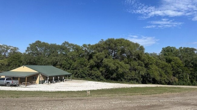
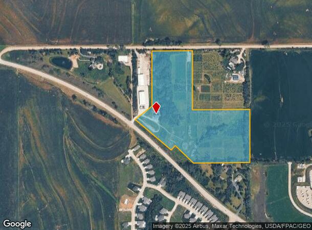
This Property Is For Sale
NEARBY LISTINGS FOR SALE OR LEASE
Property Detail
16102 State Highway 36
Omaha/Council Bluffs
Bennington Farms
Omaha-Council Bluffs, NE-IA
BENNINGTON FARMS LOT 1 BLOCK 0 LOT 1 APPROX 22.63 AC
0943-9000-06
Douglas
Agriculturalland
Nebraska
2024
1
2025
22.63 AC
007318
Northwest Omaha
DEMOGRAPHICS near 16102 State Highway 36
1 Mile
3 Mile
5 Mile
2024 Total Population
1,387
8,714
32,178
2029 Population
1,408
9,008
33,502
Pop Growth 2024-2029
+ 1.51%
+ 3.37%
+ 4.11%
Average Age
39
36
37
2024 Total Households
484
2,813
10,964
HH Growth 2024-2029
+ 1.65%
+ 3.16%
+ 3.99%
Median Household Inc
$116,197
$119,880
$122,832
Avg Household Size
2.90
3.00
2.90
2024 Avg HH Vehicles
2.00
2.00
2.00
Median Home Value
$339,204
$359,482
$338,129
Median Year Built
2003
2008
2010
Nearby Places
Map Layers
Map Styles
 Street
 Aerial
- Restaurants
- Banks
- Shops
- Fitness
- Groceries
PUBLIC TRANSPORTATION
AIRPORT
Eppley Airfield
DRIVE
WALK
Distance
Eppley Airfield
31 min
17.8 mi
Freight Ports
Tulsa Port Of Catoosa
DRIVE
WALK
Distance
Tulsa Port Of Catoosa
486 min
437.4 mi
Nearby Properties
Address
Land Use
TOTAL SIZE
Lot Size
Zoning
Address
Land Use
TOTAL SIZE
Lot Size
Zoning
228,963 SF
7.36 AC
Address
Land Use
TOTAL SIZE
Lot Size
Zoning
149,081 SF
9.01 AC
Address
Land Use
TOTAL SIZE
Lot Size
Zoning
106,465 SF
11.11 AC
Address
Land Use
TOTAL SIZE
Lot Size
Zoning
17,940 SF
3.47 AC
Address
Land Use
TOTAL SIZE
Lot Size
Zoning
27,500 SF
1.80 AC
Address
Land Use
TOTAL SIZE
Lot Size
Zoning
11,379 SF
2.16 AC
Address
Land Use
TOTAL SIZE
Lot Size
Zoning
12,556 SF
1.84 AC
MU
Address
Land Use
TOTAL SIZE
Lot Size
Zoning
10,980 SF
1.30 AC
Address
Land Use
TOTAL SIZE
Lot Size
Zoning
32,360 SF
2.89 AC
Address
Land Use
TOTAL SIZE
Lot Size
Zoning
19,848 SF
1.17 AC
Address
Land Use
TOTAL SIZE
Lot Size
Zoning
25,200 SF
2.70 AC
Address
Land Use
TOTAL SIZE
Lot Size
Zoning
18,000 SF
1.38 AC
Address
Land Use
TOTAL SIZE
Lot Size
Zoning
10,080 SF
1.39 AC
Address
Land Use
TOTAL SIZE
Lot Size
Zoning
200.44 AC
Address
Land Use
TOTAL SIZE
Lot Size
Zoning
30,000 SF
2.58 AC
Address
Land Use
TOTAL SIZE
Lot Size
Zoning
18,000 SF
1.33 AC
Address
Land Use
TOTAL SIZE
Lot Size
Zoning
26,880 SF
3.33 AC
Address
Land Use
TOTAL SIZE
Lot Size
Zoning
11,075 SF
3.66 AC
LC
Address
Land Use
TOTAL SIZE
Lot Size
Zoning
2,356 SF
150.55 AC
AG
Address
Land Use
TOTAL SIZE
Lot Size
Zoning
2,060 SF
34.25 AC
AG
Address
Land Use
TOTAL SIZE
Lot Size
Zoning
19,996 SF
0.66 AC
Address
Land Use
TOTAL SIZE
Lot Size
Zoning
15,176 SF
0.87 AC
BENNINGTON
Address
Land Use
TOTAL SIZE
Lot Size
Zoning
7,500 SF
0.55 AC
BENNINGTON
Address
Land Use
TOTAL SIZE
Lot Size
Zoning
13,288 SF
1.06 AC
Address
Land Use
TOTAL SIZE
Lot Size
Zoning
6,250 SF
1.01 AC
Address
Land Use
TOTAL SIZE
Lot Size
Zoning
12,000 SF
4.11 AC
Address
Land Use
TOTAL SIZE
Lot Size
Zoning
10,560 SF
0.22 AC
Address
Land Use
TOTAL SIZE
Lot Size
Zoning
2,481 SF
10.01 AC
05-AGRICUL
Address
Land Use
TOTAL SIZE
Lot Size
Zoning
9,775 SF
0.22 AC
The World's #1 Commercial Real Estate Marketplace
Connect with us
© 2025 CoStar Group
The information above has been obtained from sources believed reliable. While we do not doubt its accuracy we have not verified it and make no guarantee, warranty or representation about it. It is your responsibility to independently confirm its accuracy and completeness. Any projections, opinions, assumptions, or estimates used are for example only and do not represent the current or future performance of the property. The value of this transaction to you depends on tax and other factors which should be evaluated by your tax, financial, and legal advisors. You and your advisors should conduct a careful, independent investigation of the property to determine to your satisfaction the suitability of the property for your needs.