No Photo
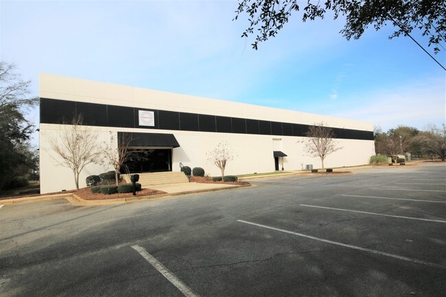
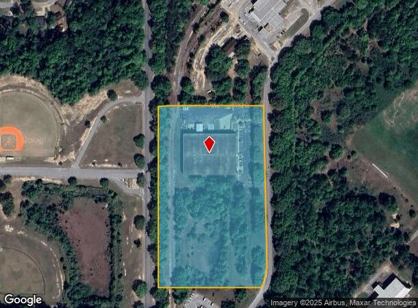
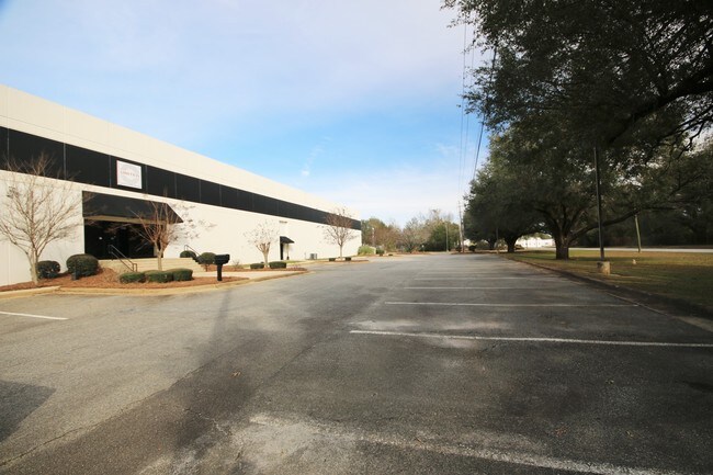
Property Record
1611 Krug St, Albany, GA 31705
NEARBY LISTINGS FOR SALE OR LEASE
Property Detail
1611 Krug St
Albany, GA
Turner Field Rd
0000T-00001-002
PLAT 5-53 LL 193 1ST DIST.
Publicstorage
Dougherty
D
Georgia
13321C0175D
193
2025
10.41 AC
2024
Albany/Southwest
011200
Other Market Areas
52,176 SF
DEMOGRAPHICS near 1611 Krug St
1 Mile
3 Mile
5 Mile
2024 Total Population
2,773
20,142
50,231
2029 Population
2,732
19,727
49,238
Pop Growth 2024-2029
(1.48%)
(2.06%)
(1.98%)
Average Age
36
36
38
2024 Total Households
1,034
7,778
20,184
HH Growth 2024-2029
(1.55%)
(2.11%)
(2.11%)
Median Household Inc
$14,193
$31,300
$36,330
Avg Household Size
2.60
2.40
2.30
2024 Avg HH Vehicles
1.00
1.00
1.00
Median Home Value
$63,901
$80,571
$98,618
Median Year Built
1962
1976
1972
Nearby Places
Map Layers
Map Styles
 Street
 Aerial
- Restaurants
- Banks
- Shops
- Fitness
- Groceries
PUBLIC TRANSPORTATION
AIRPORT
Southwest Georgia Regional
DRIVE
WALK
Distance
Southwest Georgia Regional
19 min
9.6 mi
Freight Ports
Port of Panama City
DRIVE
WALK
Distance
Port of Panama City
238 min
163.8 mi
SALE & LEASE HISTORY
LISTING DATE
SALE/LEASE

Apr 28, 2017
For Sale
Nearby Properties
Address
Land Use
TOTAL SIZE
Lot Size
Zoning
Address
Land Use
TOTAL SIZE
Lot Size
Zoning
34,888 SF
164.47 AC
M2
Address
Land Use
TOTAL SIZE
Lot Size
Zoning
243,722 SF
226.11 AC
M2
Address
Land Use
TOTAL SIZE
Lot Size
Zoning
58.86 AC
C3
Address
Land Use
TOTAL SIZE
Lot Size
Zoning
3,664 SF
1,672.02 AC
C1
Address
Land Use
TOTAL SIZE
Lot Size
Zoning
1.77 AC
C2
Address
Land Use
TOTAL SIZE
Lot Size
Zoning
15.20 AC
C2
Address
Land Use
TOTAL SIZE
Lot Size
Zoning
250.69 AC
C5
Address
Land Use
TOTAL SIZE
Lot Size
Zoning
1.75 AC
C2
Address
Land Use
TOTAL SIZE
Lot Size
Zoning
50,000 SF
50.37 AC
C3
Address
Land Use
TOTAL SIZE
Lot Size
Zoning
141,600 SF
45.43 AC
C1
Address
Land Use
TOTAL SIZE
Lot Size
Zoning
77,688 SF
2.93 AC
C3
Address
Land Use
TOTAL SIZE
Lot Size
Zoning
70,596 SF
2.38 AC
C2
Address
Land Use
TOTAL SIZE
Lot Size
Zoning
382,331 SF
30.50 AC
M1
Address
Land Use
TOTAL SIZE
Lot Size
Zoning
155,970 SF
20.89 AC
C3
Address
Land Use
TOTAL SIZE
Lot Size
Zoning
475,976 SF
51.30 AC
M1
Address
Land Use
TOTAL SIZE
Lot Size
Zoning
23,040 SF
10.59 AC
R6
Address
Land Use
TOTAL SIZE
Lot Size
Zoning
98,560 SF
19.64 AC
R6
Address
Land Use
TOTAL SIZE
Lot Size
Zoning
13,958 SF
15 AC
M1
Address
Land Use
TOTAL SIZE
Lot Size
Zoning
28,713 SF
9.96 AC
C3
Address
Land Use
TOTAL SIZE
Lot Size
Zoning
30,336 SF
19.19 AC
R6
Address
Land Use
TOTAL SIZE
Lot Size
Zoning
5,560 SF
12.88 AC
R6
Address
Land Use
TOTAL SIZE
Lot Size
Zoning
10,608 SF
45.66 AC
M1
Address
Land Use
TOTAL SIZE
Lot Size
Zoning
52,844 SF
18.09 AC
R6
Address
Land Use
TOTAL SIZE
Lot Size
Zoning
34,560 SF
7.46 AC
R6
Address
Land Use
TOTAL SIZE
Lot Size
Zoning
6,952 SF
0.83 AC
R6
Address
Land Use
TOTAL SIZE
Lot Size
Zoning
3,397 SF
7.93 AC
R6
Address
Land Use
TOTAL SIZE
Lot Size
Zoning
34,746 SF
3.14 AC
C3
Address
Land Use
TOTAL SIZE
Lot Size
Zoning
12,544 SF
10.72 AC
R6
Address
Land Use
TOTAL SIZE
Lot Size
Zoning
2,726 SF
6.29 AC
R6
Address
Land Use
TOTAL SIZE
Lot Size
Zoning
384 SF
547.90 AC
COMMERCIAL
The World's #1 Commercial Real Estate Marketplace
Connect with us
© 2026 CoStar Group
The information above has been obtained from sources believed reliable. While we do not doubt its accuracy we have not verified it and make no guarantee, warranty or representation about it. It is your responsibility to independently confirm its accuracy and completeness. Any projections, opinions, assumptions, or estimates used are for example only and do not represent the current or future performance of the property. The value of this transaction to you depends on tax and other factors which should be evaluated by your tax, financial, and legal advisors. You and your advisors should conduct a careful, independent investigation of the property to determine to your satisfaction the suitability of the property for your needs.